It is easily seem that there has been no large catastropic flood in this area for at least 13,250 years !!
PREVIEW: Geologists see indications that the total accumulated displacement from
earthquakes and creep along the San Andres fault is at least 350 miles along the fault since it came into existence. Wallace Creek is an ephemeral stream in
central California, the present channel of
which displays an offset of 128 m along the
San Andreas fault which is easily seen from the air and also further down the fault is also easily seen an ancestral stream bed.
1b
Geological investigations
have elucidated the relatively simple evolution of this channel and related landforms and
deposits. This history requires that the average rate of slip along the San Andreas fault
has been 33.9 ± 2.9 mm/yr for the past 3,700
yr and 35.8 + 5.4/-4.1 mm/yr for the past
13,250 yr. Thus it is easily seem that there has been no large catastropic flood in this area for at least 13,250 years !!
The San Andreas Fault Shows the Age of the Earth !!
The infamous San Andreas fault has left its impression on the earth in California in a
number of ways! Geologists see indications that the total accumulated displacement from
earthquakes and creep is at least 350 miles along the fault since it came into existence.
Studies of a segment of the fault between Tejon Pass and the Salton Sea revealed geologically
similar terranes on opposite sides of the fault now separated by 150 miles, and some crustal blocks
may have moved through more than 20 degrees of latitude.
Its feature are readily seen from the air as shown below.
One of its many features is the offsetting of streams that cross it. This offsetting feature
can be used to demonstrate and calculate the rate of comparative movement along the fault and
the age at which these changes occurred !!
Contents
a) Holocene activity of the San Andreas fault at Wallace Creek, California
b) An Independent confirmation of the slip rates of Sieh and Jahns
c) Appendix A: Wikipedia article on the San Andreas
d) Appendix B: Calibrating Radiocarbon Dating
e) Appendix C: The Bible Affirms Radiocarbon Dating
Holocene activity of the San Andreas fault
at Wallace Creek, California
KERRY E. SIEH Division of Geological and Planetary Sciences, 170-25 California Institute of Technology, Pasadena, California 91125
RICHARD H. JAHNS* School of Earth Sciences, Stanford University, Stanford, California 94305
ABSTRACT
Wallace Creek is an ephemeral stream in
central California, the present channel of
which displays an offset of 128 m along the
San Andreas fault . Geological investigations
have elucidated the relatively simple evolution of this channel and related landforms and
deposits. This history requires that the average rate of slip along the San Andreas fault
has been 33.9 ± 2.9 mm/yr for the past 3,700
yr and 35.8 + 5.4/-4.1 mm/yr for the past
13,250 yr. Small gullies near Wallace Creek
record evidence for the amount of dextral slip
during the past three great earthquakes. Slip
during these great earthquakes ranged from
~9.5 to 12.3 m. Using these values and the
average rate of slip during the late Holocene ,
we estimate that the period of dormancy
preceding each of the past 3 great earthquakes was between 240 and 450 yr. This is
in marked contrast to the shorter intervals
(-150 yr) documented at sites 100 to 300 km
to the southeast. These lengthy intervals suggest that a major portion of the San Andreas
fault represented by the Wallace Creek site
will not generate a great earthquake for at
least another 100 yr. The slip rate determined
at Wallace Creek enables us to argue, however, that rupture of a 90-km-long segment
northwest of Wallace Creek, which sustained
as much as 3.5 m of slip in 1857, is likely to
generate a major earthquake by the turn of
the century.
In addition, we note that the long-term
rates of slip at Wallace Creek are indistinguishable from maximum fault -slip rates
estimated from geodetic data along the creeping segment of the fault farther north. These
historical rates of slip along the creeping
reach thus do represent the long-term—that
is, millennial—average, and no appreciable
elastic strain is accumulating there.
Finally, we note that the Wallace Creek
slip rate is appreciably lower than the average
rate of slip (56 mm/yr) between the Pacific
and North American plates determined for
the interval of the past 3 m.y. The discrepancy is due principally to slippage along
faults other than the San Andreas , but a
slightly lower rate of plate motion during the
Holocene epoch cannot be ruled out.
1a
Figure 1. a. Wallace Creek (WC) is along the San Andreas fault
(SAF) between Los Angeles (LA) and San Francisco (SF), in the
Carrizo Plain of Central California. b. This oblique aerial
photograph shows the modern channel which has been offset -130m, and
an abandoned channel that has been offset -380 m. An older abandoned
channel, indicated by white arrow at left, has been offset -475 m.
Photograph by R.E. Wallace, 17 Sep. 1974. View is northeastward.
INTRODUCTION
California has experienced many episodes of
tectonic activity during the past 200 m.y. During
the past 15 m.y. horizontal deformations due to
the relative motion of the Pacific and North
American plates have been dominant. On land,
the major actor in this most recent plate-tectonic
drama has been the San Andreas fault , across
which -300 km of right-lateral dislocation has
accumulated since the middle Miocene (Hill and
Dibblee, 1953; Crowell, 1962, 1981; Nilsen and
Link, 1975).
The San Andreas fault traverses most of
coastal California, running close to the populous
Los Angeles and San Francisco Bay regions
(Fig. la). Its historical record of occasional great
earthquakes (Lawson and others, 1908; Agnew
and Sieh, 1978) amply demonstrates that it
poses a major natural hazard to inhabitants of
these regions. The future behavior of the San
Andreas fault thus has long been a topic of great
interest to Californians. Interpretations of historical, geodetic, and geologic data have yielded
estimates of one century to several centuries for
the time between great earthquakes along the
fault in the San Francisco Bay region (Reid,
1910; Thatcher, 1975). Geologic data indicate
that similar recurrence intervals apply in southern California (Sieh, 1978b, and in press).
The behavior of the San Andreas fault during
the past few thousands of years is one of the best
clues to its future behavior. Useful forecasts concerning the likelihood or imminence of a great
earthquake along the fault will be much more
difficult without greater understanding of its behavior during the past several millennia.
In this paper, we present and discuss the geologic history of Wallace Creek, a locality about
halfway between San Francisco and Los Angeles that contains much information about the
Holocene behavior of the San Andreas fault
(Fig. la). For the purpose of determining rates
of slip in Holocene time, the channel of Wallace
Creek offers excellent possibilities. The channel
crosses and is offset along a well-defined, linear
trace of the San Andreas fault in the Carrizo
Plain of central California (Fig. lb). It is relatively isolated from other large drainages, and,
therefore, its history is not complicated by involvement with remnants of other drainages that
have been brought into juxtaposition.
The simple geometry of Wallace Creek suggests a simple history of development. Arnold
and Johnson (1909) inferred 120 m of offset on
the San Andreas fault , because the modern
channel of the creek runs along the fault for
about that distance. Wallace (1968) also inferred a simple history of offset involving incision of a channel into an alluvial plain, offset of
-250 m, then channel filling and new incision
across the fault . The latest dextral offset of 128
m then accumulated. These interpretations are
verified and quantified by us in this paper.
1b
STRATIGRAPHY AND
GEOMORPHOLOGY
Figure 2 is a geologic map of the Wallace
Creek area that is based upon surficial mapping
and study of sediments encountered in numerous excavations. The map shows four main geologic units: older fan alluvium (uncolored),
younger fan alluvium (green), high-channel alluvium (dark orange), and low-channel alluvium (light orange). A mantle of slope wash and
local alluvium, which is extensively burrowed
by rodents, overlies most of the deposits. This
unit has been mapped (brown) only where it is
thicker than ~ 1 m and does not cover units and
relationships that need to be shown on the map.
Geological Society of America Bulletin, v. 95, p. 883-896, 11 figs., 3 tables, August 1984.
Older Fan Alluvium
Underlying all other units exposed at the site, there is a late Pleistocene
alluvial fan deposit derived from the Temblor Range to the north east.
This deposit here termed the "older fan alluvium,"
consists of thin sheets, lenses, and stringers of indurate silty clay, pebbly
sandy clay, and sandy gravel. Most of the trenches (Fig. 2 and 3)
esposed this unit. Southwest of the fault, the older fan alluvium is covered
by various deposits, but northeast of the fault, the deformed
fan surface is incised.
Charcoal disseminated within the older fan alluvium 4 m below the surface of the fan
in trench 5 (Fig. 3), yielded an age of 19,340 ± 1,000 yr B.P. (Table 1). The
lack of major unconformities and paleosols in the older fan
alluvium below or above this dated horizon implies that all
of the exposed 13 m of the unit formed during the late Pleistocene epoch.
Evidence discussed below supports a conclusion that the fan surface on the
northeast side of the fault had become inactive by about 13,000 yr B.P.
Younger Fan Alluvium
Southwest of the fault (Fig. 2), there is a lobate deposit that we have termed the "younger
fan alluvium." This deposit overlies and is less
indurated than the older fan alluvium. It is a
well-sorted gravelly sand with a distinctive imbrication of pebbles that indicates southwestward current flow. The unit is thickest near
trenches 2, 9, and 10 and thins to the northwest,
southeast, and southwest. The boundary of this
composite alluvial fan is inferred from the
topography and the trench exposures. A radiocarbon date from charcoal in the upper centimetre of the older fan alluvium (trench 2)
indicates that the younger fan alluvium began to
accumulate 13,250 ± 1,650 yr B.P. (Table 1).
Figure 4. Trenches 9 and 10 reveal the various deposits of the abandoned channel
B1 and B2 are scarp-derived breccias. C1, C2 and C3 are fluvial sands and gravels.
Solid triangles indicate locations of charcoal that yielded date for
channel deposits.
High-Channel Alluvium
Nestled within the channel of Wallace Creek
above the modern stream bed, there are numerous remnants of an ancient terrace (Fig. 2). This
surface is referred to as the "high terrace," and it
is underlain by sand and gravel beds characterized by scour-and-fill structures, which we refer
to as the "high-channel alluvium" (trench 5 in
Fig. 3). The massive and poorly sorted nature of
some of these "high-channel" beds indicates that
they are debris-flow deposits. Other beds that
are well sorted and laminated must have been
transported as bedload in the waters of Wallace
Creek.
Radiocarbon analyses (3) of charcoal from
within the high-channel deposits in trench 5
demonstrate that these beds were accumulating
through a period from 5845 ± 225 yr B.P. to
3680 ± 155 yr B.P. (samples WC-3, WC-6, and
WC-7 in Table 1).
Southwest of the San Andreas fault , the highchannel deposits occur in the abandoned channel of Wallace Creek (Figs. 1 and 2). Trenches
2, 7, and 8 (Fig. 3) and 9 and 10 (Fig. 4) show
these sands and gravels residing in a 3- to 4-m deep channel cut into colluvium. Like their correlatives northeast of the fault , these beds exhibit
major episodes of scour and fill. A radiocarbon
analysis of organic matter from trench 10
yielded an age of 3,780 ± 155 yr B.P. This sample was collected from a colluvial wedge in the
middle of the deposits in the abandoned channel,
and its age indicates that the abandoned-channel
deposits are contemporaneous with the highchannel deposits across the fault and upstream.
Figure 5 includes a profile of the high terrace.
The height of the high terrace above the modern
channel is greatest at the fault ; the terrace merges
with a low terrace ~1 km upstream from the
fault . Judging from the elevation difference of
the high terrace across the fault , vertical slip during the past 3,800 yr is 3 m, which is a mere
2.3% of the horizontal slip during that time
period. It is worth noting that within 1 km to the
northwest and to the southeast, this vertical slip
diminishes to zero and reverses sense.
Modern-Channel Alluvium
Younger sand and gravel beds very similar to
the high-channel alluvium have been deposited
in the modern channel of Wallace Creek (Fig. 2,
and trench 5 in Fig. 3). Like the high-channel
alluvium, this "modern-channel alluvium" also
exhibits scour-and-fill structures and interfingers
with debris derived from the channel walls.
In trench 5, the base of the modern-channel
alluvium is —2.5 m beneath the creek bed, and
along the entire channel, there is a low terrace
that occurs 1.5 m above the modern creek bed
(Fig. 5). This terrace represents the highest level
reached by the modern-channel deposits; it
formed and was incised within the past 1,000 yr,
as indicated by the radiocarbon date of 1035 ±
235 yr B.P. on charcoal 2.5 m below the terrace
surface in trench 11 (Fig. 6). An early photograph of the channel shows that the low terrace
was incised by the creek prior to A.D. 1908
(Sieh, 1977, p. 61).
GEOLOGIC HISTORY
The evolution of Wallace Creek has been
rather simple. It is divisible into four periods,
each of which ends in a sudden change of channel configuration.
Accumulation of Older Fan Alluvium and
Initial Entrenchment of a Channel
Prior to initial incision of Wallace Creek, during the late Pleistocene epoch, the older fan alluvium gradually accumulated as broad, thin bed on an alluvial fan or apron that extended
southwestward from the Temblor Range across
the San Andreas fault (Fig. 7a). The lack of
small channels within the older fan alluvium indicates either that any scarps that formed along
the fault during this interval were buried before
they accumulated even 1 m of height, or that
they faced mountainward and served to pond
the older fan alluvium on the upstream side of
the fault . About 13,000 yr B.P., the first major
entrenchment of the older fan alluvium occurred
(Fig. 7b). Several small gullies were eroded into
the fault scarp, and their debris, the younger fan
alluvium shown in Figure 2, was deposited at
the foot of the scarp. At about the same time, the
initial entrenchment of Wallace Creek occurred.
The downstream segment of this initial channel
now lies outside the mapped area, -475 m
northwest of Wallace Creek (beneath the white
arrow at left margin of Fig. lb).
Initial Offset of Wallace Creek
and Re-entrenchment
After -100 m of right-lateral slip had been
registered by the features formed -13,000 yr
B.P., the initial downstream segment of Wallace
Creek was abandoned, and a new segment was
cut, so that a straight-channel configuration was
restored across the fault (Fig. 7c). This new
segment is the one labeled "abandoned channel"
in Figure 1.
More Offset and Re-entrenchment
of the Channel
For several millennia the newly re-entrenched
Wallace Creek served as a narrow conduit for
materials being transported fluvially out of the
nearby Temblor Range. The depth of initial incision of this channel is poorly constrained, but
it cannot have been more than 12 m, which is
the depth of the base of the high-channel deposits below the surface of the old alluvium in
trench 5. As slip accumulated along the San
Andreas fault early during the Holocene epoch,
Wallace Creek developed a bend along the fault
that reflected the offset accumulated since entrenchment (Fig. 7d). Water and debris flowing
within the channel were diverted to the right at
the fault , flowed along the fault for a distance
equal to the accumulated offset, and then were
diverted left and away from the fault . These two
bends in the channel will be referred to here in after as the right bend and the left bend.
Trench 5 indicates that by -6000 yr B.P., 3.0
to 3.3 m of sediment had been deposited within
the channel at the right bend. Trench 5 also
shows that, locally, at least 1.5 and perhaps 3.3
m of these high-channel deposits subsequently
was eroded away. About 3800 yr B.P., after the
channel had been offset -240 m, critical
changes began to occur within the channel. For
reasons that we do not understand, debris began
to accumulate in the channel to greater thicknesses than ever before (Fig. 7e). Trench 5 reveals that at the right bend, the accumulation
was at least 5.5 m deep. Trenches 2, 9, and 10
show that this accumulation all but filled the
channel at the right bend. This filling set the
stage for abandonment of the channel downstream from the right bend and re-entrenchment
of Wallace Creek straight across the fault
(Fig. 7e). The new channel was cut no more
than 8.5 m below the level of the old channel, as
the maximum depth of the new channel is only
8.5 m below the top of the high terrace in
trench 5.
Offset and Future Re-entrenchment
of the New Channel
The new channel has been offset —130 m
subsequent to its creation about 3800 yr B.P.
(Fig. 7f). The modern-channel deposits lave accumulated in the new channel during this period
of time. They are now —2.5 m thick at :he right
bend and more than 2.5 m thick at the left bend.
Although the active channel floor is now
—3 m below the crest of the channel bank at the
DISTANCE FROM FAULT
Figure S. Stream profiles of the modern and the abandoned channels of Wallace Creek. High terrace, indicated by dotted lines, and top of
high-channel alluvium, indicated by solid and dashed lines, are offset ~3 m vertically.
Figure 6. Trench 11 exposes the upper 2.5 m of low-channel deposits in the modern channel. Solid lines are contacts of individual fluvial beds.
Dotted lines represent locally visible layering within these beds.
right bend, older modern-channel deposits form
a low terrace surface that is only 1 m below the
crest of the bank there. Mr. Ray Cavanaugh,
who farms at Wallace Creek, reported to us that
water actually spilled over the edge at the right
bend in the winter of 1971-1972 or 1972-1973.
It is not hard to envision a third entrenchment of
Wallace Creek (Fig. 7g), given another metre or
two of channel filling and a moderately high
discharge. Such a re-entrenchment would establish the creek once again straight across the fault .
Figure 7. The Holocene -late Pleistocene evolution of Wallace Creek. An aggrading "older
alluvial fan" during the period including 19,300 yr ago progressively buried small scarps
formed along the San Andreas fault (SAF) during major strike-slip events (a). Right-lateral
offsets accumulated during this period, but no geomorphologically recognizable offsets began
to form until 13,250 yr ago, when the "older alluvial fan" became inactivated by initial
entrenchment of Wallace Creek (b). At this time, erosion of small gullies to the right
(southeast) of Wallace Creek also resulted in deposition of the "younger fan alluvium"
downstream from the fault . These features then began to record right-lateral offset, and scarps
began to grow along the fault . About 10,000 yr ago, a new channel was cut across the fault at
Wallace Creek, and the initial channel, downstream from the fault , was abandoned (c). The
new channel remained the active channel of Wallace Creek during the early and middle
Holocene , during which -250 m of slip accumulated (d). This channel filled with "high-
channel alluvium" 3,700 yr ago, and Wallace Creek cut a new channel straight across the
fault (e). Between 3,700 yr ago and the present, this youngest channel has registered 128 m of
right-lateral offset (f). Aggradation of this channel, accompanied by continued offset, will
probably lead to its abandonment and the creation of a new channel, cut straight across the
fault (g).
SLIP RATE OF THE
SAN ANDREAS FAULT
Slip Rate during the Late Holocene
Knowing the date of the most recent entrenchment of Wallace Creek and the offset that
has accumulated since that entrenchment, one
can calculate rather precisely the rate of slip for
the San Andreas fault . That rate is 33.9 ± 2.9
mm/yr, and its derivation is explained in detail
below.
The offset of the modern channel of Wallace
Creek is 128 ± 1 m. This figure is obtained by
extrapolating the southwestern edge of the
abandoned channel (labeled 1 in Fig. 8) to its
intersection with the fault and then measuring
the distance from that intersection to the intersection of the modern channel edge (labeled 2 in
Fig. 8) with the fault . The same value is obtained if one measures the distance between the
offset segments of the modern channel (labeled 3
and 4 in Fig. 8). In making the latter measurement of offset, it is important to realize that the
outside edge of the left bend has been eroded by
flood waters that have swept against it as they
have passed around the left bend. The right bend
has not been eroded in this manner, because it is
refreshened each time the fault slips.
The fact that feature 1 and feature 3 (Fig. 8)
intersect the fault at almost the same point
strongly suggests that the abandonment of the
high channel and entrenchment of the modern
channel were contemporaneous. This coincidence also indicates that the new channel was
cut straight across the fault without any initial
nontectonic deflection of the stream along a
fault scarp. The absence of any initial, nontectonic deflection is also confirmed by the fact that
the modern channel is entrenched thrcugh a
broad topographic high immediately downstream from the fault (consider contours in
Fig. 2). If the channel had been deflected E.long a
fault scarp, one would expect it to have cut
through a low point on the downstream side of
the fault rather than a high point. The measured
separation of 128 m thus is ascribable entirely to
tectonic offset.
The youngest date from the deposits of the
abandoned high channel (3680 ± 155 y r B.P.)
provides a maximum age for the modern channel, because all of the high-channel sediments
were deposited before the modern channel was
cut. All offset of the modern channel thus oc-
curred between this date and A.D. 1857. The
average slip rate, therefore, can be no slower
than 35.7 + 1.9 mm/yr [128 ± 1 m/3.680 ±
155-93 yr]. (93 yr is the time between A.D.
1950, which has been designated zero B.?., and
A.D. 1857.)
Additional considerations are necessary to
provide an upper limit to the slip rate. For this
constraint, trenches 9 and 10 (Fig. 4) are useful.
The high-channel deposits here consist of three
distinct units, labeled CI, C2, and C3, that represent three distinct scourings and fillings. The
uppermost sediment of channel C2 in treich 10
contained the radiocarbon sample the age of
which is 3780 ± 155 yr B.P. At the time of
deposition, CI, C2, and C3 in trenches 9 and 10
must have been at or northwest of the right bend
of Wallace Creek. Trench 9 is now .45 m
northwest of the right bend, and so no more than 145 m of dextral slip has accumulated since
channel C2 was filled 3780 ± 155 yr B.P.
The trend of C2 between trenches 10 and 9
suggests that the edge of C2 actually intersects
1a
the fault at least 10 m closer to the modern right
bend. In support of this, we note that the channel is -5 m wide and rests entirely southwest of
the fault in both trench 9 and trench 10. Sufficient channel width to accommodate a similar
deposit southwest of the fault in the modern
channel does not exist until at least 15 m downstream from the modern right bend. There, the
crest of the channel bank is ~5 m southwest of
the fault trace, and, were the channel to fill this
year, a 5-m wide deposit analagous to the channel fill in trenches 9 and 10 would be deposited.
From trench 9 to this geometrically analagous
point in the modern channel (labeled 2 in Fig. 8)
is -130 m. It seems, therefore, that no more
than 130 m of dextral slip accumulated between
3780 ± 155 yr B.P. and A.D. 1857. This yields
an upper limit of 35.3 ± 1.5 mm/yr [130
m/(3,780 ± 155 - 93 yr)] for the slip rate. This
maximum limiting rate is indistinguishable from
the minimum limiting rate of 35.7 + 1.9 mm/yr
determined previously and independently. The
rate must therefore be 35.3 ± 1.5 mm/yr, which
includes the highest maximum value (35.3 + 1.5
mm/yr) and the lowest minimum value (35.7 -
1.9 mm/yr).
The calculations thus far have assumed continuous fault displacement between 3680 yr B.P.
and A.D. 1857. It is very likely, however, that
much, and possibly all, of the slip accumulates
sporadically, during large earthquakes, such as
that which occurred in 1857. If, as we argue
below, this segment of the fault is characterized
by coseismic displacements of ~10 m, followed
by several centuries of quiet repose, the fault
could have been at any point in its earthquake
cycle 3680 yr B.P. If, in that year, the region
bisected by the fault was in the middle or toward
the end of a period of elastic strain accumulation, the rate calculated using this data will be
slightly too high, because the 128-m offset accumulated between then and 1857 is in small
part due to loading that occurred slightly earlier.
Put in a different way, the 3,680-yr date may be
any fraction of a recurrence interval younger
than the beginning of a strain accumulation
cycle. The beginning of the loading cycle corresponding to the earliest increment of the 128-m
offset thus may be any time between 3680 yr
B.P. and 3680 plus one recurrence interval. As is
seen below, the average recurrence interval here
is -310 yr, or 8% of the time between A.D.
1857 and 3680 yr B.P. The actual slip rate thus
could be as much as 8% lower than that just
calculated, or 32.5 ± 1.5 mm/yr. The late Holocene slip rate thus could be any value between
32.5 ± 1.5 and 35.3 ± 1.5 mm/yr. This range is
conveniently expressed as 33.9 + 2.9 mm/yr.
Slip Rate since 13,250 yr B.P.
An additional determination of slip rate along
the San Andreas fault at Wallace Creek comes
from the 475-m offset of a 13,250-yr-old alluvial
fan from its source gullies. This provides an average slip rate of 35.8 + 5.4/-4.1 mm/yr, which
is not appreciably different from the late Holocene rate of 33.9 ± 2.9 mm/yr.
The 13,250-yr-old alluvial fan constitutes the
"younger fan alluvium" mapped in Figure 2.
The fan radiated from a point that is now located very near the modern left bend of Wallace
Creek. Its existence is reflected in the bulging of
the 2,240-, 2,250-, and 2,260-ft contours toward
the southwest (Fig. 2). Even though it is now
buried by 1.5 to 2 m of unmapped slope wash
and bioturbated materials, the bulging of the
contours and measurements of thickness in
trenches 2, 3,4, and 6 enable construction of the
isopach map of the younger fan alluvium shown
in Figure 9.
Trench 2 (Fig. 3) exposes the sediments of the
fan near its apex. There, the sediments constitute
a 1.3-m-thick bed of well-sorted, imbricated
sandy gravel. The gravel is composed of tabular
pebbles of diatomaceous Tertiary marine mudstone. Imbrication of these tabular pebbles
clearly indicates a flow direction toward the
southwest. The source of the alluvial fan thus
must be on the opposite side of the San Andreas
fault . Although the fan is composed of three
discrete beds in trench 2 (see detailed log of
trenches, available from author), the lack of
bioturbation or weathering of the two horizons
between these beds suggests that the fan was
deposited very rapidly, perhaps in a matter of a
few decades or less.
The deposit overlies a massive, poorly sorted
sandy loam that represents either a colluvial unit
or an alluvial deposit that was extensively bioturbated prior to burial. The unit probably lay at
the ground surface for a long time prior to burial
by the alluvial fan. The presence of charcoal
pebbles and granules in this unit, no more than a
centimetre or two beneath the base of the fan,
suggests that a range fire occurred just prior to
deposition of the fan. The charcoal certainly
would have been oxidized if it had not been
buried deeply very soon after its formation. Erosion of the fan materials from their source within
the burned area may have been a direct result of
the fire, which removed protective vegetative
cover from the ground surface. The charcoal age
of 13,250 ± 1,650 yr B.P. thus represents the age
of the basal unit of the overlying alluvial fan.
If the source of the younger fan sediments
were Wallace Creek, the fan would be offset a
mere 128 m. This would imply that the fault
was inactive between about 13,000 yr and about
3700 yr B.P., because we have just shown that
128 m of slip has occurred since about 3700 yr
B.P. Such a long period of dormancy along the
San Andreas fault seems very unlikely to us, and
so we seek a source for the younger fan that is
farther to the southeast.
The volume of the fan is -25,000 m3. Candidates for the source gully (or gullies) must have
total eroded volumes at least as great as this and
preferably somewhat larger, because some of the
material transported out of the source region
must have been carried beyond the alluvial fan
as suspended load and bedload.
Given this constraint, only two plausible
sources for the fan exist within 1 km of Wallace
Creek. The first is a solitary channel -730 m
southeast of the fan apex (E in Fig. 1). This
channel originates in the Temblor Range but
drains a much smaller area than Wallace Creek.
If this is the source, an average slip rate of -63
mm/yr for the period 13,250 to 3700 yr B.P. is
calculated:
This would indicate fluctuations in slip rate of at
least several centimetres per year during the past
13,000 yr, because the average rate for the past
3,800 yr has been -34 mm/yr.
More likely sources for the alluvial fan are
four closely spaced gullies several hundred
metres southeast of the fan apex (A, B, C, and D
in Fig. 1 ). In Figure 9, these have been restored
to their probable location at the time of formation of the fan. None of these four small gullies,
which extend only a few hundred metres back
from the fault scarp, could have been the sole
provider of enough material to construct the entire fan. The volumes of A, B, and C are only
-13,000 m3 each, and D is much smaller. In
any combination, however, they could have
delivered enough material.
The proper matching of this multiple source
with the younger fan deposit can be determined
rather precisely. If the general reconstruction
shown in Figure 9 is correct, the southeastern
Figure 9. Isopach map of 13,250-yr-old alluvial fan and source gullies B and C. In this figure, the gullies have been
restored 475 m to their late Pleistocene position upstream from the fan. The same gullies are indicated by letters B and
C in Figure lb. For reference, dotted line represents location of modern channel of Wallace Creek. Isopach map is
based on trench exposures (thick, open bars) and geometry of contours. Insert in upper right illustrates use of
topographic contours in constructing isopach map. Lower edge of stippled region is topographic contour. Upper edge
is contour prior to deposition of fan. Southwestward bulging of contours indicates presence and thickness of alluvial
fan.
flank of the main fan complex had to be southeast of channel C. The offset thus is no less
than 472 m. At the same time, the crests of the
two distinct lobes of the fan shown in Figure 9
should have had their apexes at the mouths of
two of the middle gullies. Only gullies B and C
are spaced appropriately to meet this constraint.
The mouth of gully B cannot be offset more than
478 m, if B is the source of the northwestern
lobe of the fan. It is of interest that the younger
fan deposits are offset from gullies A, B, C, and
D, only slightly less so than the oldest, beheaded
channel of Wallace Creek itself (marked with a
white arrow at the left margin of Fig. 1). The
creation of gullies A, B, C, and D must, therefore, be nearly contemporaneous with the fnst
entrenchment of Wallace Creek.
These considerations constrain the offset of
the younger fan deposits to 475 ± 3 m. In that
the younger fan formed 13,250 ± 1650 yr B.P.,
the average slip rate must be 35.8 + 5.4/-4.1
mm/yr. Within the level of resolution, this cannot be distinguished from the average late Holo-
cene rate of 33.9 ± 2.9 mm/yr.
RECURRENCE INTERVALS
BETWEEN PAST
LARGE EARTHQUAKES
AT WALLACE CREEK
The average Holocene and late Holocene
rates of slip at Wallace Creek are important new
measurements of strain across the San Awireas
fault in central California, because they are the
first to span more than a fraction of a great
earthquake cycle of strain accumulation and relief. These millennial averages can be used in
conjunction with other data to infer earthquake
recurrence intervals.
For example, the length of the cycle of strain
accumulation that preceded and led to the great
1857 earthquake can be calculated. In 1857, the
San Andreas fault sustained 9.5 m of right-lateral slip at Wallace Creek. This is indicated
by five small offset gullies nearby (A, B, C, D,
and E in Fig. 1; Table 2), as well as by small
offset gullies at distances of as much as several
kilometres to the northwest and southeast. These
gullies were incised across the fault prior to the
1857 event, but after the previous large event
(see Sieh, 1978c, for a more detailed discussion).
If one assumes that the 9.5 m of fault slip associated with the 1857 earthquake relieved elastic
strains that had accumulated in the adjacent
crustal blocks at an average rate of 34 mm/yr,
one calculates that the 1857 earthquake was
preceded by a 280-yr period of strain accumulation. This calculation does not assume that annual strain accumulation was uniform during
the 280-yr period, but only that the average annual rate was equal to the millennial average of
34 mm/yr. Periods of faster or slower accumulation thus could be accommodated within the
over-all loading cycle. Table 2 (top of col. 5)
displays the actual range of values for the period
of strain accumulation if the uncertainties in the
1857 offset value and average slip rate are taken
into account. In lieu of a direct dating of the
large event that preceded the 1857 event at Wallace Creek, this range (240-320 yr) is probably
the best estimate that can be made for the recurrence interval between the 1857 earthquake and
its predecessor.
Estimates of the duration of two earlier periods of strain accumulation can also be made,
using the average late Holocene slip rate and the
'1857(240 to 320 yr).
t|857 (560 to 740 yr).
§1857-(840toll40yr).
amount of fault slip associated with each of the
last two prehistoric earthquakes. Table 2 lists the
data that suggest these 2 events were associated
with -12.3 and 11.5 m of fault slip at Wallace
Creek. At 34 mm/yr, these values would have
accumulated in 360 and 340 yr, respectively.
The actual range in value for both of these recurrence intervals, calculated using the ranges in
value for the slip rate and the offsets, is displayed
in column 5 of Table 2. From the table, one can
see that the latest 3 recurrence intervals are estimated to be within the range of 240 to 450 yr.
Of course, it is possible that the 4,000-yr and
13,000-yr average slip rates do not represent the
average rate of strain accumulation during the
periods of fault dormancy prior to 1857 and the
2 previous great earthquakes. For example, the
rate of accumulation actually could have been
much higher during the past millennium and
much slower during the previous 4,000-yr interval. If so, the recurrence intervals between the
latest few earthquakes would be much shorter
than those calculated above. Perhaps a future
study of a currently undiscovered 1,000-yr-old
feature near Wallace Creek will resolve this
issue by providing a 1,000-yr average rate. Alternatively, the past several earthquakes may be
dated directly, as has been done at Pallett Creek
(Sieh, 1978b, in press). In the meantime, the
validity of using the 3,700-yr average slip rate in
calculating recurrence intervals of recent and future great earthquakes must be assessed in other
ways.
First, the slip rate averaged over the past
3,700 yr (33.9 ± 2.9 mm/yr) does not differ
appreciably from the 13,000-yr average (35.8 +
5.4/-4.1 mm/yr), although the 13,000-yr average conceivably could be as much as 10 mm/yr
(-30%) faster than the late Holocene average,
given the imprecision of the 2 determinations.
Second, geodetic data on modern rates of
strain accumulation across the fault are available
from the "Carrizo" net, which spans the fault
and 80 km of adjacent territory at the latitude of
Wallace Creek (Savage, 1983, and 1982, written commun.). These data are available, however, only for the period 1977.6 to 1981.5. The
deformation observed during this period aver-
ages 0.29 ± 0.06 /ustrain/yr (extension) N89° ±
4°W and -0.09 ± 0.06 justrain/yr (contraction)
north-south. Numerous models of lithospheric
deformation can produce this observed surficial
deformation. One class of model involves the
assumption that the observed deformations are
the result of aseismic right-lateral slip on the San
Andreas fault beneath its locked, brittle upper
10 or 20 km. In this case, the observed deformations of the Carrizo net are resolved as right-lateral shear strains parallel to the San Andreas
fault . The average shear strain over the entire
80-km-wide network is 0.38 ± 0.04 /żrad/yr.
This translates into a deep slip rate on the fault
of 30.4 ± 3.2 mm/yr, if one assumes that the
network spans the entire zone of deformation
due to slip on the fault . If it does not span the
entire zone, the rate of deep slip on the fault
must be higher. Like the 13,000-yr average rate,
the geodetically determined modern rate does
not differ significantly from the 3,700-yr
average.
The similarity of the 13,000-yr, 3,700-yr, and
4-yr averages suggests that strain accumulation
across the fault may be fairly uniform. Of
course, numerous histories could be invented
that include these three data points and yet involve large fluctuations in the strain accumula-
tion rate between earthquake cycles or recurrence intervals. To date, however, no known
data support large fluctuations. A reasonable as-
sumption, thus, is that the late Holocene average
slip rate represents the average rate of strain accumulation between large earthquakes. The recurrence intervals displayed in Table 2 may,
therefore, be realistic estimates of the dormant
intervals that preceded the past three great
earthquakes.
In the next section, we attempt to assess when
the current earthquake cycle will end at Wallace
Creek; that is, when the next great earthquake,
accompanied by rupture at Wallace Creek, will
occur. We also attempt to use the 3,700-yr average slip rate to assess the likelihood of large
earthquakes elsewhere along the San Andreas
fault .
FORECASTS OF THE BEHAVIOR
OF THE SAN ANDREAS FAULT
Along the South-Central (1857) Segment
If the crust adjacent to the San Andreas fault
has been accumulating strain at 34 mm/yr since
1857, as much as 4.3 m of potential slip has now
been stored and conceivably could be released
along all or part of the 1857 rupture. Geomorphologie data, however, suggest that this is likely
only along two portions of the 1857 rupture.
Wallace Creek is not within either of these
portions.
Figure 10 displays offsets measured along the
south-central segment of the San Andreas fault .
The 1857 segment is divisible into at least three
parts, based on slippage during the 1857 earthquake and one to four previous large earth-
quakes. The southeastern part is ~90 km long
and seems to have been characterized by 3- to
4.5-m slip events. The central 160 km, including
Wallace Creek, has experienced 7 to 12.3 m of
slip during the most recent 3 great earthquakes.
The lower values along this central portion
occur along the reach between km 90 and km
200, where several other active faults to the
north and northeast exist, and so the lower
values may reflect distributed deformation,
away from the San Andreas fault . A 30-km
segment northwest of Wallace Creek experienced 3 to 4 m of slip in 1857 and probably 1
or 2 during previous large earthquakes, as well.
These data suggest that each part of the fault
has experienced a characteristic amount of slip-
Figure 10. Right-lateral offsets measured along the south-central (1857) segment of the San
Andreas fault suggest that slip at each locality is characterized by a particular value. Solid
circles are data from Sieh (1978c), with poor-quality data deleted. Open circles are data from
Davis (1983). Triangles are new data and remeasurements at sites reported by Sieh (1978c).
Open squares are new data. Vertical bars indicate magnitude of imprecision in measurement.
page during the past three to four large earthquakes. Although, of course, so few data do not
provide a statistically sound basis for predicting
all previous and future events, we are confident
that this pattern offers seme insight into the
long-term behavior of the fault .
At least two explanations are worth considering. First, we consider the possibility that the
northwestern 40 km and southeastern 90 km are
loaded more slowly, and, therefore, when the
earthquake occurs, they experience lesser
amounts of slip than does the central 160-km-
long part. This is unlikely, because the average
Holocene slip rate along these two parts nust be
nearly equal to the rate determined at Wallace
Creek. Just beyond the south-central segment, at
Cajon Creek (Fig. 10), the San Andreas las average Holocene and late Holocene slip rates of
25 ± 3 mm/yr (Weldon e.nd Sieh, 1981). The
nearby San Jacinto and related subparallel faults
probably carry ~10 mm/yr at this latitude
(based on data of Sharp, 1981, and Metzger,
1982). These fault systems end and nearly merge
with the San Andreas fault just northwest of
Cajon Creek. Farther northwest, the San Andreas fault is the only major active structure, and
so northwest of Cajon Creek, it must have a slip
rate of —35 mm/yr. In addition, the average
recurrence interval for large earthquakes at Pallett Creek (location in Fig. 10) is in the range of
145 to 200 yr, which is appreciably shorter than
the 240- to 450-yr range at Wallace Creek. For
this reason, some of the slip events shown in
Figure 10 in the Palmdale-Pallett Creek region
must have their northwestern rupture tip southeast of Wallace Creek, and 1857-like events
cannot be the only type of slip event along this
part of the south-central segment.
The northwestern 30 km of the south-central
segment (Fig. 10) must also share the long-term
average slip rate of Wallace Creek. No diversion
of a large fraction of the Wallace Creek rate
along other structures is plausible. The only
known major active(?) fault nearby is the San
Juan Hill fault , which runs 3 to 14 km west of
and subparallel to the San Andreas from about
Cholame to Wallace Creek (Jennings and others, 1975). Its rate of slip is probably no more
than a few millimetres per year.
A second explanation fcr the different behavior of the three parts of the south-central segment is based on the hypothesis that each part is
imbued with a different strength. If, for reasons
of geometry or rock properties, the cent'al 160
km of the segment were 2 or 3 times stronger
than the 2 other parts, 2 or 3 times a;, much
elastic loading of the adjacent crustal blocks
would be necessary before failure occurred.
Each failure thus would result in two to three
times as much slippage as on the two adjacent
parts. Such an explanation is compatible with
our judgments that (1) slip rate does not vary
greatly along the south-central segment, and
(2) large earthquakes are more frequent at
Pallett Creek than at Wallace Creek.
Table 3 lists our best estimates of the dates of
large earthquakes at Wallace Creek and proposed correlations with large earthquakes that
have been directly dated at Pallett Creek (Sieh,
in press) and at Mill Potrero (Davis, 1983). The
capital letters in Figure 10 reflect our best judgment regarding correlation of the latest events at
Wallace Creek, Pallett Creek, and Mill Potrero.
Event X at Pallett Creek (A.D. 1720 ± 50) has
no correlative at Wallace Creek, although Davis
(1983) discovered evidence for and dated a relatively small slip event at Mill Potrero that may
well be event X. Event V at Pallett Creek occurred about A.D. 1550, which is about the time
we estimate that the last prehistoric event at
Wallace Creek occurred, and also about the
time of a large slip event that Davis (1983) discovered at Mill Potrero. Similarly, events R and
F at Pallett Creek occurred at about the time we
estimate that the third and fourth events occurred at Wallace Creek.
On the basis of the foregoing discussion, we
judge that the central 160 km of the southcentral segment of the San Andreas fault is un-
likely to generate a great earthquake for at least
another 100 yr. Recurrence intervals appear to
be in the range of 250 to 450 yr, and yet the time
elapsed since the great earthquake of 1857 is
only 127 yr. Slip during the latest 3 great earthquakes has been 7 to 12.3 m, and yet we suspect
that only a little more than 4 m of potential slip
has been stored in the past 127 yr.
The southeastern 90 km and the northwestern
30 km of the south-central segment are good
candidates for producing a large earthquake
within the next several decades. Geomorpho-
logie measurements seem to indicate that 3 to
4.5 m of slip is characteristic during large events,
and >4 m of potential slip may well have been
stored in the adjacent crustal blocks since 1857.
Based on studies at Pallett Creek, the probability
of a great event along the southeastern 90 km of
the south-central segment within the next 50 yr
is between 26% and 98% (Sieh, in press).
Along the Creeping Segment
The long-term average slip rates determined
at Wallace Creek are indistinguishable from the
geodetically determined rates of slip at deep levels along the fault from Wallace Creek to Monterey Bay (Savage, 1983; Lisowski and Prescott,
1981). The long-term rates at Wallace Creek are
also identical to the historical rate of slip at shallow levels along the central 50 km of the creep-
ing segment (see data compiled by Lisowski and
Prescott, 1981, Fig. 6). These similarities could
be coincidental, but they suggest that the central
50 km of the creeping segment is creeping annually at its millennial-average rate of slip. If this
were true, it would mean that large elastic
strains are not accumulating across the central
50 km of the creeping segment, and that this
segment will not participate in the generation of
the next large earthquakes along the San Andreas fault .
From a geological point of view, it is reasonable to suspect that the long-term slip rate along
the San Andreas fault at Wallace Creek should
not be different from its long-term rate along the
creeping segment, except along its northernmost
50 km, adjacent to which runs the actively
creeping Paicines fault (Harsh and Pavoni,
1978). No other large, active structures in the
latitudes of the creeping segment can be called
upon to absorb a large portion of the slip rate
observed farther south at Wallace Creek. Likewise, there are no obvious geological structures
near the San Andreas that would lead one to
suspect that the long-term slip rate along the
creeping segment is appreciably higher than the
long-term rate farther south.
Along the 90-km Segment
Centered on Cholame
between the central 50 km of the creeping
zone and Wallace Creek, there is a stretch of the
San Andreas fault that historically has been a
zone of transition between the fully creeping and
fully locked portions of the fault. On the basis of
available data, this segment is a prime candidate
for generating a large earthquake in the near
future. In the period of historical record, it has
not experienced as much slip as have segments
to the northwest or southeast, and it is therefore
a "slip gap."
One interpretation of the historical data is illustrated in Figure 11, in which cumulative
right-lateral slip for the past two centuries is plotted as a function of location along the fault.
We assume that creep rates northwest of Cholame have been constant for the past few
hundred years, so that the alignment array data
for the period 1968-1979 are representative of
the pre- and post-1857 creep rates. We also assume that Cholame has been the edge of the
creep zone throughout this period. In the century preceding 1857, 3 to 3.5 m of slip would
have accumulated by creep northwest of Slack
Canyon. Less slip would have accumulated by
creep, and perhaps during occasional moderate
earthquakes, between Slack Canyon and
Cholame.
In 1857, —3.5 m of slip occurred along the
30-km stretch of the fault southeast of Cholame,
and 9.5 m of slip occurred in the vicinity of
Wallace Creek. The sparse historical accounts
are compatible with our inference in Figure 11
that slippage during the earthquake decreased
northwestward from Cholame and died out near
Slack Canyon (Sieh, 1978c, p. 1423-1424).
Following 1857, creep resumed northwest of
Cholame. Northwest of Slack Canyon, —4.5 m
of slip now has accumulated at the full, longterm rate of loading of the fault (that is, 34
mm/yr). The 60-km-long section between Slack
Canyon and Cholame, however, has crept at
rates that are significantly lower than the loading
rate, and strain is being stored in the rocks adjacent to the fault there. Similarly, elastic strains
are accumulating in the rocks adjacent to the
locked portion of the fault, and the northernmost 30 km of this portion, which seems to fail
in 3- to 4-m slip events, may well be loaded
nearly to the point of failure.
We suggest that this northernmost part of the
locked segment and the southernmost part of the
creeping segment might fail in unison and produce a major earthquake. This hypothetical
event would be associated with —90 km of surface rupture and a maximum of-4.3 m of right-
lateral slip.
In discussing this hypothetical event, it is important to note that the great 1857 earthquake
seems to have originated in this region. Sieh
(1978a) documented that at least 2 moderate
foreshocks occurred in this vicinity about 1.5
and 2.5 hr prior to the main shock. Within the
past century, 5 moderate (M5.5 to 6) earthquakes have been produced by slippage along
the San Andreas fault northwest of Cholame.
Sieh (1978a) inferred that the 1857 foreshocks
emanated from a source similar to that which
produced these historical shocks. If this is true,
then the next moderate "Parkfield-Cholame"
earthquake might well be a foreshock of the
hypothetical major event described above.
ROLE OF THE SAN ANDREAS
FAULT IN THE RELATIVE MOTION
OF THE NORTH AMERICAN
AND PACIFIC PLATES
Minster and Jordan (1978) determined from
a circumglobal data set that the relative motion
of the Pacific and North American plates has
averaged ~56 mm/yr during the past 3 m.y.
The geological record at Wallace Creek shows
that, at least during the past 13,000 yr, only -34
mm/yr of this has been accommodated by slip
along the San Andreas fault. If one assumes that
the 3-m.y. average represents the Holocene average rate across the plate boundary as well,
then clearly the San Andreas fault is accommodating only -60% of the relative plate motion.
The remainder of the deformation must be accomplished elsewhere within a broader plate
boundary. The San Gregorio-Hosgri fault system, which traverses the coast of central Cali-
fornia, may have a late Pleistocene-Holocene
slip rate of 6 to 13 mm/yr (Weber and Lajoie,
1977), and the Basin Ranges, to the east of the
San Andreas fault, may be opening N35°W on
oblique normal faults at a late Pleistocene-Holocene rate of-7 mm/yr (Thompson and Burke,
1973). Most of the 56 mm/yr plate rate thus
may be attributed to the San Andreas, San Gregorio-Hosgri, and Basin Range faults. Longterm slip rates on these three major fault systems
are not known precisely enough to preclude or
confirm the possibility that the rate of relative
plate motion during the Holocene is equal to the
3-m.y. average. No clear basis exists, however,
for suggesting that the Holocene rate is less than
or more than the longer-term rate.
ACKNOWLEDGMENTS
Wallace Creek is named after Robert Wallace, who elucidated the basic history of the
channel more than 15 years ago and provided us
with a special topographic base map. N.
Timothy Hall drew our attention to the study
site. He and Laurie Sieh participated in initial
studies. Art Fairfall and John Erickson at the
University of Washington provided all of the
radiocarbon analyses. Robert Wallace, David
Schwartz, David Pollard, Christopher Sanders,
and Ray Weldon provided helpful criticisms of
earlier manuscripts. This work was supported by
the National Earthquake Hazards Reduction
Program, U.S. Geological Survey Contract nos.
14-08-0001-15225, 16774, 18385, and 19756.
REFERENCES CITED
Agnew, D.. and Sieh, K., 1978, A documentary sludy of the fell effects of the
great California earthquake of 1857: Seismological Society of America
Bulletin, v. 68, p. 1717 1729.
Arnold, R., and Johnson, H. R„ 1909, The earthquake rift in eastirn San Luis
Obispo County, California: Science, v. 29, no. 744, p, 558.
Crowell, J„ 1962, Displacement along the San Andreas Fault California:
Geological Society of America Spec ial Papers, v, 71, 61 p.
1981, An outline of the tectonic h:slory of southeastern California, in
Ernst, W. C. ed.. The geotectonic development of Califcrnia: Engle-
wood Cliffs, New Jersey. Prentice-Hall, p. 584 600.
Davis, T.. 1983, Late Cenozoic structure ind tectonic history of the western
"Big Bend" of the San Andreas Fau t and adjacent San Em gdio Moun-
tains [Ph.D. dissert.]: Santa Barbara, California, University of Califor-
nia, Department of Geological Sciences.
Harsh, P., and Pavoni, N., 1978, Slip on the Paicines fault: S:ismological
Society of America Bulletin, v. 68, ;3. 1191-1194.
Hill, M., and Dibblee, T., Jr., 1953, San Andreas, Garlock and Biji Pine faults.
California—A study of their charac:er, history and tectonic significance
of their displacements: Geological Society of America Bulletin, v, 64.
p. 443-458.
Jennings, C, and others, 1975, Fault map of California: CaliforniE Division of
Mines and Geology California Geological Data Map Serie:. Map no, 1.
Klein, J.. Lerman. J. C, Damon, P. E .. and Ralph, E. K... 1982. Calibration of
radiocarbon dates: Tables based on the consensus data of th z Workshop
Calibrating the Radiocarbon Time Scale: Radiocarton. v. 24,
p. 103-150,
Lawson, A., and others, 1908, The Gilifornia earthquake of April 18,
1906—Report of the State Eanhquike Investigation Comnission: Wa-
shington, D.C, Carnegie Institution of Washington. 2 columes and
atlas, 461 p.
Lisowski, M„ and Prescotl, W. H.. 1981. Short range distance measurements
along the San Andreas fault system in central California: Seismological
Society of America Bulletin, v. 71, no. 5, p. 1607 1624.
Metzger, L., 1982, Tectonic implications of the Quaternary history of Lower
Lytle Creek, southeastern San Gat riel Mountains [B.A. thesis): Clare-
mont, California, Pomona College.
Minster, J. B.. and Jordan. T. H., 1978, Present-day plate motion;: Journal of
Geophysical Research, v. 83. no. B . 1, p. 5331 5334.
Nilsen, T., and Link, M. H., 1975, Stratigraphy, sedimentology ant offset along
the San Andreas fault of Eocene to lower Miocene strata of the northern
Santa Lucia Range and the San Emigdio Mountains. Coast Ranges,
centra] California, i>r Weaver, D. W,, and others, eds., Palcogene Sym-
posium and selected technical papers: Conference on Future Energy
Horizons of the Pacific Coast, Annual Meeting AAPG-SEPM-SEG,
Long Beach, California, p. 367-400.
Reid, H. F., 1910, Permanent displacements of the ground, in Tl e California
earthquake of April 18, 1906—Retron of the State Earthq take Investi-
gation Committee: Washington, D.C Carnegie Institution of Washing-
ton, v. 2, p. 16 28.
Savage, J. C, 1983, Strain accumulation in western United States: Annual
Reviews of Earth and Planetary Science, v. 11, p. 11 43.
Sharp, R. V., 1981, Variable rates of late Quaternary strike slip on the San
Jacinto fault zone, southern California: Journal of Geo jhysical Re-
search, v. 86. p. 1754-1762.
Sieh, K., 1977. Late Holocene displacement history along the touth-central
reach of the San Andreas Fault [Ph.D. dissert.]: Stanforc, California,
Stanford University, 219 p.
1978a. Central California foreshocks of the great 1857 earthquake:
Seismological Society of America Eiulletin. v. 68, p. 1731 1749.
1978b, Pre-historie large earthquakes produced by slip on the San
Andreas fault at Pallet! Creek, California: Journal of Geophysical Re-
search, v. 83, p. 3907 3939.
1978c, Slip along the San Andreas fault associated with th: great 1857
earthquake: Seismological Socie.y of America Bulletin, v. 68,
p. 1421 1428,
in press. Lateral offsets and revised elates of large prehistoric earthquakes
at Pallen Creek, southern California: Journal of Geophysical Research.
Stuiver, M., 1982, A high-precision calibration of the AD radiocarbon time
scale: Radiocarbon, v. 24. no. I, p. 1 26.
Stuiver, M„ and Polach, H. A.. 1977, Discussion: Reporting of 4C data:
Radiocarbon, v. 19. no. 3. p. 355-J.63.
Thatcher. W., 1975, Strain accumulation on the northern San Andreas fault
zone since 1906: Journal of Geophysical Research, v. 80, no. 35,
p. 4873 4880.
Thompson, G. A., and Burke, D. B„ 1973, Rate and direction of spreading in
Dixie Valley, Basin and Range province, Nevada: Geologic al Society of
America Bulletin, v. 84, p. 627 632.
Wallace, R. E.. 1968, Notes on stream channels offset by the San Andreas fault,
southern Coast Ranges, California, in Dickinson, W., anc Grantz, A„
eds.. Conference on Geologic Problems of San Andreas Fault System.
Proceedings: Stanford University Publications in the Geological
Sciences, v. 11. p. 6-21.
Weber, G. E., and Lajoie, K. R.. 1977. Late Pleistocene and Holoc:ne tectonics
of the San Gregorio fault zone between Moss Beach anil Point Ano
Nuevo, San Mateo County, California: Geological Society of America
Abstracts with Programs, v. 9. no. 4. p. 524.
Weldon. R. J., and Sieh, K. E., 1981. Offset rale and possible timing of recent
earthquakes on the San Andreas fi.ult in Cajon Pass. California [abs.]:
EOS (American Geophysical Union Transactions), v. 62. no. 45,
p. 1048.
Manuscript Received by the Society November 10, 1982
Revised Manuscript Received September 2, 1983
Manuscript Accepted September 22, 1983
Contribution No 3819, Division of Geological and Planetar
Sciences. California Institute of Technology
Printed in U.S.A.
An Independent confirmation of the slip rates of Sieh and Jahns
Title:
Stream Channel Offset and Preliminary Slip Rate on the San Andreas Fault, at the Van Matre Ranch Site, in the Carrizo Plain, California
Authors:
Noriega-Carlos, G. R.; Grant, L. B.; Arrowsmith, R.; Young, J. J.
Affiliation:
AA(University of California, Irvine, Environmental Health, Science and Policy, Irvine, CA 92697-7070 United States ; gnoriega@uci.edugnoriega@uci.edu), AB(University of California, Irvine, Environmental Health, Science and Policy, Irvine, CA 92697-7070 United States ; lgrant@uci.edulgrant@uci.edu), AC(Arizona State University, Department of Geological Sciences, Tempe, AZ 85287-1404 United States ; ramon.arrowsmith@asu.eduramon.arrowsmith@asu.edu), AD(Arizona State University, Department of Geological Sciences, Tempe, AZ 85287-1404 United States ; jeri.young@asu.edujeri.young@asu.edu)
Publication:
American Geophysical Union, Fall Meeting 2004, abstract #G11A-0772
To understand the spatial and temporal variation in fault slip it is important to improve the spatial coverage of slip and slip rate measurements along major active faults. A set of well-preserved channels are offset across the San Andreas fault at the Van Matre Ranch (VMR) site (35.154N, 119.700W) in the Elkhorn Hills area of the Carrizo Plain. The fault zone and offset channels at VMR were exposed by excavation in 1993 and 2004. This study included one fault-perpendicular and 5 fault-parallel trenches that exposed the buried thalwegs of several offset channels. Seventeen samples were collected from channel margin deposits for 14C dating and survey data was taken for accurate offset measurement of the buried thalwegs and geomorphic channels. The geomorphic history of the site is well manifested in the excavations with clear evidence for initial incision of the channels into Plio-Pleistocene fan units that were typically heavily bioturbated. The channels then back filled and the stratified channel sediments grade laterally into clayey silts. The buried thalweg of the currently active channel is offset 24.8 m, while the geomorphic offset is 27.6 m (qualitatively defined conservative uncertainties on offsets are ± 1m). The thalweg of the first beheaded channel is offset 48.8 m with a geomorphic offset of 51.8 m. The geomorphic offset of the second beheaded channel ranges from 71.9 to 79.0 m. There are no ages associated with these channels. The median dates of samples from the clayey silts in the currently active channel margin range between A.D. 1221 and 1108, implying a 34.7 mm/yr slip rate. The significance of the samples ages is dependent upon interpretation of the sediments in which they were collected. They were collected from clayey silts which are either colluvium, washed down from adjacent hill slopes, or autochthonous alteration of the channel deposits by pedogenic processes (largely burrowing). If the samples were derived from colluvial processes, the ages of the samples would provide a maximum slip rate. However, if the samples were derived from older channel sediments, then they would indicate a slip rate minimum. This preliminary slip rate is consistent with the measured slip rate at Wallace Creek, approximately 18 km to the northwest where Sieh and Jahns documented a late Holocene slip rate of approx. 33.9 ± 2.9 mm/yr, and with the regionally assumed 35-mm/yr rate derived from decadal time-scale geodetic measurements.
See the following appendices for more information
Appendix A: Wikipedia article on the San Andreas
Appendix B: Calibrating Radiocarbon Dating
Appendix C: The Bible Affirms Radiocarbon Dating
Appendix A Wikipedia article on the San Andreas
San Andreas Fault
From Wikipedia, the free encyclopedia
Exaggerated altitude image of the San Andreas Fault on the Carrizo Plain in central California, 35°07'N, 119°39'W. The picture is a composite of radar data and a Landsat photo.
Aerial photo of the San Andreas Fault in the Carrizo Plain
The San Andreas Fault can be divided into three segments.
Map of the San Andreas Fault, showing relative motion.
The southern segment (known as the Mojave segment) begins near the Salton Sea at the northern terminus of the East Pacific Rise and runs northward before it begins a slow bend to the west where it meets the San Bernardino Mountains. It runs along the southern base of the San Bernardino Mountains, crosses through the Cajon Pass and continues to run northwest along the northern base of the San Gabriel Mountains. These mountains are a result of movement along the San Andreas Fault and are commonly called the Transverse Range. Near Palmdale, a portion of the fault is easily examined as a roadcut for the Antelope Valley Freeway runs directly through it.
After crossing through Frazier Park,
the fault begins to bend northwards. This area is referred to as the
“Big Bend” and is thought to be where the fault locks up in Southern California
as the plates try to move past each other. This section of the fault
has an earthquake-recurrence interval of roughly 140-160 years.
Northwest of Frazier Park, the fault runs through the Carrizo Plain,
a long, treeless plain within which much of the fault is plainly
visible. The Elkhorn Scarp defines the fault trace along much of its
length within the plain.
The central segment of the San Andreas fault runs in a northwestern direction from Parkfield to Hollister.
While the southern section of the fault and the parts through Parkfield
experience earthquakes, the rest of the central section of the fault
exhibits a phenomenon called aseismic creep. This term describes the fault being able to move without causing earthquakes.
Map showing the San Andreas (reds and orange) and major "sister" faults in the San Francisco Bay Area
All land west of the fault on the Pacific Plate
is moving slowly to the northwest while all land east of the fault is
moving southwest (relatively southeast as measured at the fault) under
the influence of plate tectonics. The rate of slippage averages approximately 33-37 mm/year across California. [1]
The westward component of the motion of the North American Plate
creates compressional forces which are expressed as uplift in the Coast
Ranges. Likewise, the northwest motion of the Pacific Plate creates
significant compressional forces where the North American Plate stands
in its way, creating the Transverse Ranges in Southern California, and
to a lesser, but still significant, extent the Santa Cruz Mountains,
site of the Loma Prieta Earthquake of 1989.
Studies of the relative motions of the Pacific and North American
plates have shown that only about 75 percent of the motion can be
accounted for in the movements of the San Andreas and its various
branch faults. The rest of the motion has been found in an area east of
the Sierra Nevada mountains called the Walker Lane
or Eastern California Shear Zone. The reason for this is not as yet
clear, although several hypotheses have been offered and research is
ongoing. One hypothesis which gained some currency following the Landers Earthquake in 1992 is that the plate boundary may be shifting eastward, away from the San Andreas to the Walker Lane.
Assuming the plate boundary does not change as hypothesized,
projected motion indicates that the landmass west of the San Andreas
Fault, including Los Angeles, will eventually slide past San Francisco,
then continue northwestward toward the Aleutian Trench,
over a period of perhaps twenty million years. On the other hand, if
the plate boundary shifts eastward, then the entire state of California
would move in the same direction.
In central California is the small town of Parkfield, California,
which lies along the San Andreas Fault. Seismologists discovered that
this section of the fault consistently produces magnitude 6.0
earthquakes about every 22 years. Following earthquakes in 1857, 1881,
1901, 1922, 1934, and 1966, scientists predicted an earthquake to hit Parkfield in 1993. This quake eventually struck in 2004 (see Parkfield earthquake).
Because of this frequent activity and prediction, Parkfield has become
one of the most popular spots in the world to try to capture and record
large earthquakes.
In 2004, work began just north of Parkfield on the San Andreas Fault Observatory at Depth
(SAFOD). The goal of SAFOD is to drill a hole nearly 3 kilometers into
the Earth's crust and into the San Andreas Fault. An array of sensors
will be installed to capture and record earthquakes that happen near
this area.[2]
[edit]The University of California study on "the next big one"
A study completed by Yuri Fialko[3]
has demonstrated that the San Andreas fault has been stressed to a
level sufficient for the next "big one," as it is commonly called, that
is, an earthquake of magnitude
7.0 or greater. The study also concluded that the risk of a large
earthquake may be increasing faster than researchers had previously
believed. Fialko also emphasized in his study that, while the San
Andreas Fault had experienced massive earthquakes in 1857 at its
central section and in 1906 at its northern segment (the great San
Francisco earthquake), the southern section of the fault has not seen a
similar rupture in at least 300 years.
"The information available suggests that the fault is ready for the
next big earthquake but exactly when the triggering will happen and
when the earthquake will occur we cannot tell," Fialko said. "It could
be tomorrow or it could be 10 years or more from now," he concluded in
September of 2005.
Recent studies of past earthquake traces on both the northern San Andreas Fault and the southern Cascadia subduction zone
indicate a correlation in time which may be evidence that quakes on the
Cascadia subduction zone may have triggered most of the major quakes on
the northern San Andreas during at least the past 3,000 years or so.
The evidence also shows the rupture direction going from north to south
in each of these time-correlated events. The 1906 San Francisco
Earthquake seems to have been a major exception to this correlation,
however, as it was not preceded by a major Cascadia quake, and the
rupture moved mostly from south to north. [4]
The San Andreas Fault has had some notable earthquakes in historic times:
1857 Fort Tejon earthquake
— 350 kilometers were ruptured in central and southern California.
Though it is known as the Fort Tejon earthquake, the epicenter is
thought to have been located far to the north, just south of Parkfield.
Only two deaths were reported. The magnitude was about 8.0
1906 San Francisco Earthquake
— 430 kilometers were ruptured in Northern California. The epicenter
was near San Francisco. About 3000 people died in the earthquake and
subsequent fires. This time the magnitude was estimated to be 7.8.
1989 Loma Prieta earthquake
— 40 kilometers were ruptured (although the rupture did not reach the
surface) near Santa Cruz, California, causing 63 deaths and moderate
damage in certain vulnerable locations in the San Francisco Bay Area.
Magnitude this time was about 7.1. The earthquake also postponed game 3
of the 1989 World Series at Candlestick Park.
2004 Parkfield earthquake — on 28 September2004
at 10:15 AM, a magnitude 6.0 earthquake struck California on the San
Andreas Fault. This earthquake was originally expected in 1993 based on
the latest earthquake prediction theories of the time, but eleven years
passed before the predicted event occurred. Despite the extra time
between events, the magnitude of the earthquake was no larger then
anything.
Appendix B
Radiocarbon Calibration by Richard G. Fairbanks, Columbia University
The
radiocarbon content of the atmosphere and surface ocean depends upon
the solar flux, Earth’s geomagnetic field intensity, and the carbon
cycle
The records of the 14C content of the
atmosphere and oceans contain a remarkable array of information about
Earth history. Produced by cosmic rays in the upper atmosphere,
14CO2 rapidly mixes throughout the troposphere and exchanges with the
reactive carbon reservoirs of the oceans and biosphere, where it
decays. For the past 11,000 years, fluctuations in the atmospheric
14C have been largely produced by changes in the solar magnetic
field. Many researchers believe that carbon cycle changes, tied to
deep ocean circulation changes are a significant cause of atmospheric
14C fluctuations between 11,000 and 15,000 years before present. On
longer time scales, changes in the Earth’s magnetic field intensity
impact the 14C content of the atmosphere, producing positive 14C
anomalies during intervals of weaker geomagnetic field.
Of practical
importance to a wide range of scientific disciplines is the
radiocarbon calibration, which is used for converting radiocarbon
ages to calendar years; essential for measuring time and rates of
change for numerous scientific fields. To access our radiocarbon
calibration program, click on the 'Radiocarbon Calibration Program'
button above, or here.
Arguably, few research topics engage so many different fields of
science and have such a profound impact on our understanding of Earth
and Solar science as the history of 14C in the Earth's atmosphere and
the surface and deep oceans. Over the past decade we have witnessed
a remarkable development and proliferation of accelerator mass
spectrometers; these instruments have reduced the counting time by a
factor of 100 and reduced the sample size by a factor of 1000
compared to the classic B-counting systems. It is estimated that
nearly 90% of all measurements made at the more than 50 active
accelerator mass spectrometry laboratories are radiocarbon dates.
This dramatic increase in the number of radiocarbon dates is driving
the demand for a radiocarbon calibration program that spans the
entire radiocarbon timescale from the present to 55,000 years BP.
Extension of the 14C record beyond the 0 to 11,900 year long tree
ring record is well underway, being measured in many different
archives, and undoubtedly an enormous amount of scientific knowledge
will stem from these studies. In our laboratory, we have overlapped
and extended the tree-ring radiocarbon calibration from 3,000 to
55,000 yrs. BP using coral samples from our offshore coral reef core
collections from Barbados (13.10°N; 59.32°W) in the western tropical
Atlantic and Kiritimati Atoll (1.99°N, 157.78°W) in the central
equatorial Pacific, and from the uplifted reefs of Araki Island
(15.63°S; 166.93°E) in the western Pacific. In addition, we have
reanalyzed the radiocarbon and
230Th/234U/238U age dates from our
earlier radiocarbon calibration work using new pretreatment and
analytical techniques and state-of-the-art instrumentation at higher
precision; we report these new results in this WEB site and in
Fairbanks et al., (2005).
In our radiocarbon calibration paper (Fairbanks et al., 2005), we
present paired 230Th/234U/238U (Lamont) and 14C age determinations
(Lawrence Livermore National Lab and Leibniz-Labor for Radiometric
Dating and Isotope Research Christian-Albrechts University Kiel) that
span the entire range of the radiocarbon dating technique and present
a radiocarbon calibration curve based on a Bayesian statistical model
with rigorous error estimations. Due to the importance of an
accurate and precise radiocarbon calibration curve, we have measured
many samples in duplicate and validated the quality of the samples by
dating the older samples with redundant
231Pa/235U dates. Our online
radiocarbon calibration curve presented in this WEB site is a stand
alone alternative to existing radiocarbon calibration curves that
infer calendar ages based on interpolations and correlations of local
climate proxies in deep-sea cores to the chronology of ice core
proxies or assumptions about sedimentation rates. Our calibration
has the advantage that each data point in the calibration has a
measured calendar age (230Th/234U/238U)
and radiocarbon age with know
errors that are independent from each other. In a series of
published papers and manuscripts soon to be published, we present our
analytical techniques in detail (Mortlock et al., 2005; Chiu et al.,
2005a) and the geochemical (Cao et al., 2005) and geophysical
(Chiu et al., 2005b, 2005c) explanations for the departure of radiocarbon
dates from the true calendar ages and compare our results to other
radiocarbon calibration data.
Comparisons of Fairbanks Radiocarbon Calibration data and curve and IntCal04 data and curve
The tree ring atmospheric radiocarbon calibration data set spanning 0
to
12,410 years BP is superior to all other atmospheric radiocarbon
calibration data due to the number and quality of the radiocarbon
measurements and the accuracy and precision of the tree
dendrochronology (Stuiver et al., 1998; Reimer et al., 2004). The
Fairbanks curve (Fairbanks et al., 2005; 2007) and IntCal04 curve
(Reimer et al., 2004) use the same tree ring data set from 0 to 12,410
cal yr B.P. and the two different radiocarbon calibration programs
yield nearly identical results over this interval (See CalPal web site
for a comparison). There are presently two
choices for calibration curves beyond 12,410 years BP: IntCal04
(Hughen et al., 2004) to 26,000 years or our calibration curve
(Fairbanks et al., 2005) from 0 to 55,000 years BP. In our
judgment the choice is clear but let us review the differences. The
IntCal04 includes predominantly laminated sediments from the Cariaco
Basin from 11,900 to 14,000 years BP along with coral data from
numerous investigators of varying sample quality based on the
reported presence of calcite in samples analyzed by some of the
contributors. In contrast, our calibration program (Fairbanks et al.,
2005; 2007) uses the 1382-ring floating tree ring data set from Kromer
et al., (2004) for the time interval between 12,600 and 14,000 yrs BP
anchored by our coral data set. Over this time interval, the Caricao
data set used by IntCal04 differs by more than 200 years from the tree
ring and our coral calibration data. The photo images of the Cariaco
sediment layering (Hughen et al., 2004) shows very weak to indistinct
layers in the 13,250 to 14,000 year interval where the offset of
Cariaco data with the tree ring and coral data sets is most apparent.
In a recent study (*Bondevik et al., 2006), Reimer, the lead author of
the IntCal04 paper) and her colleagues retract the Cariaco calibration
data in IntCal04 data set and IntCal04 calibration curve and inserted
the floating tree ring data set in its place. In their 2006 paper they
state that:
The
part of the new calibration curves that relies on tree-ring evidence
(IntCal04) dates back to 12,410 calendar (cal) yr B.P. Beyond that and
back to 14,700 cal yr B.P., IntCal04 is mainly constructed from 14C
dates of foraminiferas from Venezuela.s Cariaco basin that are
corrected for a constant reservoir age of 405 years. However, it has
been proposed that the latter increased up to 650 years during the
Bolling/Allerod. We therefore replaced that part of IntCal04 with a
new, floating tree-ring curve composed of 1382 rings between 10,650 and
12,000 14C yr B.P. . Thus our tree-ring record from IntCal04, combined
with the new, floating tree-ring curve, represents a true terrestrial
curve that extends across most of the studied interval.
All previous attempts to use layered sediments for radiocarbon
calibration purposes have not stood the test of time and the Cariaco
basin calibration data used in IntCal04 are apparently no exception
(Bondevik et al., 2006).
From 14,000 to 26,000 years BP, 80% of the data in
the IntCal04 were provided by our laboratory and we have subsequently
doubled the amount of data in the 14,000 to 26,000 year BP time
interval (Cao et al., 2006; Fairbanks et al., 2005; 2006).
IntCal04 ends at 26,000 cal yr B.P. representing only 50% of the
radiocarbon age dating range. Our calibration extends to the limits of
radiocarbon age dating to 50,000 cal yrs B.P. using the same coral
sample and data quality control measures and dating techniques as
applied to our younger samples and those we provided to IntCal04.
Another difference between the selections of
IntCal04 versus our calibration
program is philosophical. Seven years elapsed between publication of
IntCal98 and IntCal04 although the majority of new data between
14,000 and 26,000 are from our laboratory. It is unclear when the
next internationally ratified calibration curve will be approved but
it is presumably many years away. Meanwhile, Reimer and colleagues
(Bondevik et al., 2006) have already retracted a segment of the Cariaco
layered sediment data set used in IntCal04 but the .official. IntCal04
file has not been revised. On the other hand, we are
increasing the number of new calibration data pairs by 50% per year
over the next 3 years. We appreciate the value of a stable
internationally-ratified radiocarbon calibration curve, however
researchers
want the best available calibration curve in order to make the most
accurate and precise conversion of radiocarbon years to calendar
years. Considering the dramatic increase in ocean, climate, and
archeological research spanning the deglacial, glacial and Marine
Isotope Stage 3, there is a high and growing demand for radiocarbon
calibration. We recommend that researchers and editors always list
their raw radiocarbon ages and laboratory sample identification code
and simply identify the calibration version used for their calibrated
ages. This permits anyone to revise calibrated ages as our
calibration curve is periodically updated over the next three years.
In order to ensure that there is not a proliferation of calibration
curves using outdated versions of our calibration data, we only offer
an on line version. We will update our calibration curve every year and
publish the data within 12 months of the update. To
better serve the archeological community, we will also release the
calibration data and access to our curve to CalPal at the same time
we update our curve. The curve will be updated every year on
Jan 1 and versions are identified as Fairbanks followed by
the month and year such as Fairbanks0107 for the upcoming version.
There are already enough calibration data such that
our curve is stable and the primary improvements with future versions
will be in the reduction in computed calendar year uncertainties. We
continue to measure the 231Pa/235U ages of the samples that have been
exposed to vados fresh water in order to provide quality assurance. Our
goal is to have redundant 231Pa/235U dates on all calibrations ages
between 30,000 and 55,000 years BP within one year of publishing new
230Th/234U/238U dates.
*Bondevik, S., J. Mangerud, H.H. Birks, S. Gulliksen and P. Reimer,
2006. Changes in North Atlantic radiocarbon reservoir ages during the
Allerod and Younger Dryas. Science, 312, 1514-1517.
Publications:
[PDF]
Chiu, T-C, R. G. Fairbanks, Li Cao, Richard A. Mortlock, 2007. Analysis of the atmospheric 14C record spanning the past 50,000 years derived from high-precision 230Th/234U/238U and
231Pa/235U and 14C dates on fossil
corals. Quaternary Science Reviews, 26, 18-36.
[PDF]
Chiu, T-C, R.G. Fairbanks, R.A. Mortlock, L. Cao, T.W. Fairbanks, and
A.L. Bloom, 2006. Redundant 230Th/234U/238U and
231Pa/235U dating of fossil corals: verification of U-series
ages for radiocarbon calibration. Quaternary Science Reviews, in press.
[PDF]
Fairbanks, R.G., T-C Chiu, Li Cao, Richard A. Mortlock and Alexey
Kaplan, 2006. Reply to the comment by Yusuke Yokoyama and Tezer M.
Esat. Quaternary Science
Reviews Correspondence, 26, 3084-3087.
[PDF]
Chiu, T-C, R.G. Fairbanks, R.A. Mortlock and A.L. Bloom, 2005. Extending the
radiocarbon calibration beyond 26000 years before present using
fossil corals. Quaternary Science Reviews, 24, 1797-1808.
[PDF]
Fairbanks, R.G., R.A. Mortlock, T.-C. Chiu, L. Cao, A. Kaplan, T.P.
Guilderson, T.W. Fairbanks and A.L. Bloom, 2005.
Marine Radiocarbon Calibration Curve Spanning 10,000 to 50,000 Years
B.P. Based on Paired 230Th/234U/238U
and 14C Dates on Pristine Corals. Quaternary Science
Reviews, 24, 1781-1796.
[PDF]
Mortlock, R.A., R.G. Fairbanks, T. Chiu, and J. Rubenstone, 2005.
230Th/234U/238U and
231Pa/235U ages from a single fossil coral
fragment by multi-collector magnetic-sector inductively coupled
plasma mass spectrometry. Geochim. et Cosmochim. Acta, 69, 3, 649-657.
[PDF]
Hughen, KA, Baillie, MGL, Bard, E, Bayliss, A, Beck, JW, Blackwell,
PG, Buck, CE, Burr, GS, Cutler, KB, Damon, PE, Edwards, RL,
Fairbanks, RG, Friedrich, M, Guilderson, TP, Herring, C, Kromer, B,
McCormac, FG, Manning, SW, Ramsey, CB, Reimer, PJ, Reimer, RW,
Remmele, S, Southon, JR, Stuiver, M, Talamo, S, Taylor, FW, van der
Plicht, J, and Weyhenmeyer, CE. 2004. Marine04 Marine radiocarbon age
calibration, 0-26 cal kyr BP. Radiocarbon 46, 3, 1059-1086.
[PDF]
Reimer, PJ, Baillie, MGL, Bard, E, Bayliss, A, Beck, JW, Blackwell,
PG, Buck, CE, Burr, GS, Cutler, KB, Damon, PE, Edwards, RL,
Fairbanks, RG, Friedrich, M, Guilderson, TP, Herring, C, Hughen, KA,
Kromer, B, McCormac, FG, Manning, SW, Ramsey, CB, Reimer, PJ, Reimer,
RW, Remmele, S, Southon, JR, Stuiver, M, Talamo, S, Taylor, FW, van
der Plicht, J, and Weyhenmeyer, CE. 2004. IntCal04 Terrestrial
radiocarbon age calibration, 0-26 cal kyr BP. Radiocarbon 46,
3, 1029-1058.
[PDF]
Shackleton, N.J., R.G. Fairbanks, T-C Chiu, and F. Parrenin, 2004.
Absolute calibration of the Greenland time scale: implications for
Antarctic time scales and for Δ14C. Quaternary Science Reviews, 23, 1513-1522.
Bard, E., M. Arnold, R.G. Fairbanks and B. Hamelin, 1993.
230Th/234U and 14C ages obtained by
mass spectrometry on corals. In Stuiver, M., A. Long, and R.S. Kra,
eds. Calibration 1993. Radiocarbon, 35, 1, 191-200.
[PDF]
Bard, E., B. Hamelin, R.G. Fairbanks, A. Zindler, 1990.
Calibration of the 14C timescale over the past 30,000 years using mass
spectrometric U-Th ages from Barbados corals.
Nature, 345, 405-410.
Bard, E., B. Hamelin, R.G. Fairbanks, A. Zindler, G. Mathieu, M.
Arnold, 1990. U/Th and 14C ages of corals from Barbados
and their use for calibrating the 14C time scale beyond
9000 years BP. Nuclear Instruments and Methods, B52, 461-468.
Appendix C
C14 dating affirms Scripture/Scripture affirms C14 dating!
San Francisco Chronicle
A judgment about Solomon Evidence supports
Hebrew kingdoms in biblical times
David Perlman,
Chronicle Science Editor
Deep in the ruins of a Hebrew town sacked nearly 3,000
years ago by an Egyptian Pharaoh, scientists say they have
discovered new evidence for the real-life existence of the
Bible's legendary kingdoms of David and Solomon.
The evidence refutes recent claims by other researchers who
insist that the biblical monarchs were merely mythic
characters, created by scholars and scribes of antiquity who
made up the tales long after the events to buttress their own
morality lessons.
The debate, however, is not likely to subside, for
archaeology is a field notable for its lengthy quarrels among
partisans, however scientific they may be.
The latest evidence comes from Israeli and Dutch
archaeologists and physicists after seven years of digging at
a historic site called Tel Rehov. The site is in the Jordan
valley of Israel, where successive settlements rose and fell
over the centuries.
Using highly sophisticated techniques for establishing
dates through the decay rate of radioactive carbon, the
scientists have pinned down the time of a disputed moment in
history, recorded in the Bible, when a Pharaoh now known as
Shoshenq I invaded Jerusalem.
As the book of Chronicles relates in the Old Testament,
Shoshenq (the Bible called him Shishak) came "with twelve
hundred chariots and threescore thousand horsemen" and
plundered Israel's capital, as well as such towns and
fortresses as Rehov, Megiddo and Hazor.
The Pharaoh later listed those conquests on a monument in
the temple of Amun at Karnak, where the Egyptian city of Luxor
now stands.
11=Gaza, Genesis 10:19, Joshua 10:41
12=Makkedah, Joshua 10:10
13=Rubuti,
14=Aijalon, Joshua 21:24
15=Kiriathaim?,
16=Beth- horon, Joshua 10:10
17=Gibeon, Joshua 9:3
18=Mahanaim, Genesis 32:2, Joshua13:26
19=Shaud[y],
20=?,
21=Adoraim, 2 Chronicles 11:9
22=Hapharaim, Joshua 19:9
23=Rehob, Numbers 13:21, Joshua 19:28
24=Betshan,
25= Shunem, Joshua 19:18
26=Taanach, Joshua 12:21
27=Megiddo, Joshua 12:21
28=Adar, Joshua 15:3
29=Yadhamelek,
(List and second photo from http://www.specialtyinterests.net/sheshonk.html)
The new timetable places Shoshenq's rampage and looting at
Rehov in the 10th century rather than the 9th, a highly
significant difference. It sets the date at about 925 B.C.,
some five years after Solomon was said to have died, and some
80 years earlier than other archaeologists maintain.
Those scholars, known in the world of archaeology as
"minimalists," insist that both David and Solomon were little
more than tribal chieftains, and certainly not the mighty
monarchs of the Bible.
A report on the new evidence appears today in the journal
Science by Hendrik Bruins, a desert researcher at Ben-Gurion
University of the Negev in Israel, Johannes van der Plicht of
the Center for Isotope Research at the University of Groningen
in the Netherlands, and Amihai Mazar of the Hebrew University
of Jerusalem, the principal archaeologist at Tel Rehov.
In a telephone interview, Mazar said that one specific
"layer of destruction" at the site yielded a harvest of
charred grain seeds and olive pits that enabled his colleagues
to date them with an unusually high level of precision. The
dates of both earlier and later layers showed clearly how the
successive layers of occupation could be determined from the
12th through the 9th centuries B.C., he said.
"They provide a precise archaeological anchor for the
united monarchies of the time of David and Solomon," Mazar
said. "The pottery we found there also tells us that the
conquest dates from the same period as Meggido, when its
mighty gates and walls and temples were also destroyed by
Shoshenq's armies."
More than 40 years ago the late Yigael Yadin, who won fame
as an army officer during Israel's war for independence,
turned to archaeology and after excavating the imposing ruins
at Megiddo maintained that they were in fact destroyed during
the so-called Solomonic period.
Recently, however, a group of archaeologists led by Israel
Finkelstein of Tel Aviv University working at Megiddo has
insisted that the so-called Solomon's gate there dates from a
much later time -- perhaps 100 or even 200 years after
Solomon.
Finkelstein read a copy of the Mazar report that was sent
him by e-mail. After replying that Mazar "is a fine scholar,"
he insisted that "there are many problems with his
archaeological data" and that the samples of material used for
the radiocarbon dating are at best questionable.
In the past, Finkelstein has accused Mazar of harboring a
"sentimental, somewhat romantic approach to the archaeology of
the Iron Age," according to an earlier account in Science.
On Thursday, however, one of the leaders in the archaeology
of Israel, Professor Lawrence E. Stager, who is director of
Harvard University's Semitic Museum, dismissed the claims of
Finkelstein and the other archaeologists who share his views.
"Mazar and his colleagues have now put another nail in the
coffin of Finkelstein's theories," Stager said. "There's no
question that Rehov and the other cities that Shoshenq
conquered were indeed there at the time of Solomon.
"We don't need to rely any more only on the Bible or on
Shoshenq's inscriptions at Karnak to establish that Solomon
and his kingdom really existed, because we now have the superb
evidence of the radiocarbon dates."
copied from http://sfgate.com/cgi-bin/article.cgi?f=/c/a/2003/04/11/MN24970.DTL
Radio-dating backs up biblical text
11 September 2003
HELEN R. PILCHER
The 500 meter-long tunnel
still carries water to the city of
David
An ancient waterway, described in the Bible, has been
located and radiocarbon-dated to around 700 BC1.
The half-kilometre Siloam Tunnel still carries water
from the Gihon Spring into Jerusalem's ancient city of
David. According to verses in Kings 2 and Chronicles 2
2,
it was built during the reign of the King Hezekiah -
between 727 BC and 698 BC - to protect the city's water
supply against an imminent Assyrian siege. Critics argue
that a stone inscription close to the exit dates the
tunnel at around 2 BC.
To solve the conundrum, geologist Amos Frumkin, of
the Hebrew University of Jerusalem, and colleagues
looked at the decay of radioactive elements - such as
carbon in plants and thorium in stalactites - in tunnel
samples.
The plaster lining the tunnel was laid down around
700 BC, says Frumkin's team. A plant trapped inside the
waterproof layer clocked in at 700-800 BC, whereas a
stalactite formed around 400 BC. "The plant must have
been growing before the tunnel was excavated; the
stalactite grew after it was excavated," explains
Frumkin.
The study "makes the tunnel's age certain", says
archaeologist Henrik Bruins of Ben-Gurion University of
the Negev, Israel. The Siloam Tunnel is now the
best-dated Iron Age biblical structure so far
identified.
The remains of buildings and structures described in
the Bible are notoriously difficult to find. Specimens
are rare, poorly preserved, hard to identify and often
troublesome to access. Says James Jones, Bishop of
Liverpool, UK: "This scientific verification of
historical details in the Bible challenges those who do
no wish to take it seriously."
Tunnel vision
The samples also help to explain how the tunnel was
built. The passage is sealed with layers of plaster, the
deepest and oldest of which is directly above the
bedrock, with no sediment between. This shows that the
plaster was applied immediately after the tunnel was
built, Frumkin says.
"It's also quite unique to find well-preserved plant
remains in plaster," says Bruins. Workers may have made
up huge quantities outside the tunnel, where the plants
could have become mixed in, and then taken it inside.
Large enough to walk inside, the Siloam Tunnel
zigzags through an ancient hill. Its carved inscription
describes how two teams of men, starting on opposite
sides of the mountain, managed to meet in the middle.
They may have followed a natural fissure in the
limestone rock, Bruin suggests.
It's quite unique to find
well-preserved plant remains in plaster
Henrik Bruins Ben-Gurion
University
Unusually, the inscription does not name King
Hezekiah - other monarchs commonly boasted of their
architectural achievements in stone. The carving is six
metres inside the tunnel, so it must have been made by
lamplight.
"It wasn't meant to be seen by the public," says
Biblical historian Andrew Millard of Liverpool
University, UK. "I think it was the workmen recording
what an extraordinary feat they had
accomplished."
References
Frumkin, A., Shimron, A. & Rosenbaum, J.
Radiometric dating of the Siloam Tunnel, Jerusalem.
Nature, 425,169 - 171, (2003). |Article|
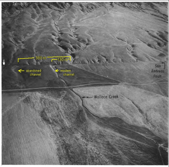 1b
1b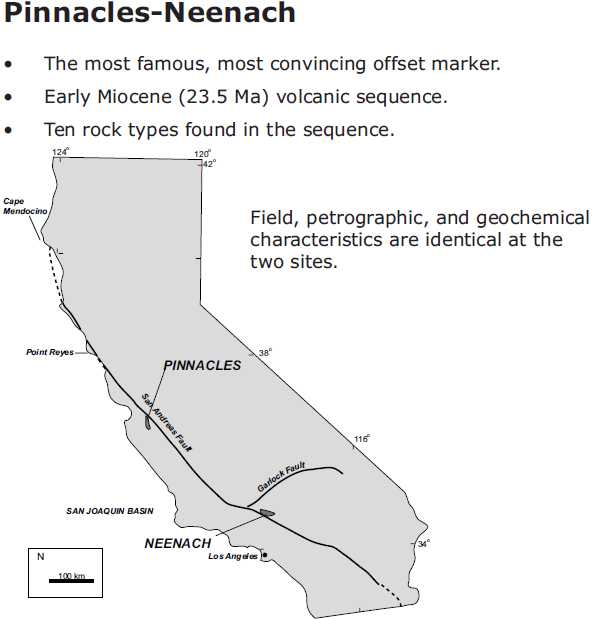
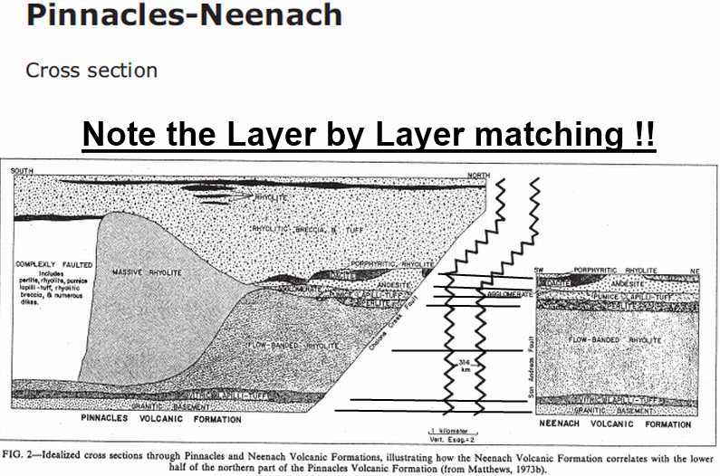
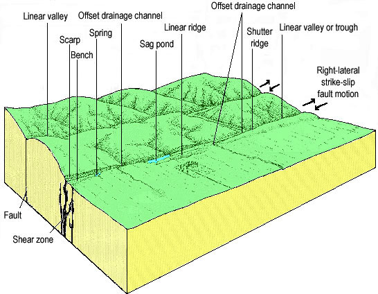
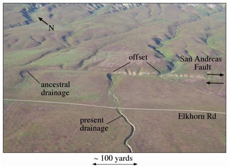
![[IMAGE]](fig_a.jpg) 1a
Figure 1. a. Wallace Creek (WC) is along the San Andreas fault
(SAF) between Los Angeles (LA) and San Francisco (SF), in the
Carrizo Plain of Central California. b. This oblique aerial
photograph shows the modern channel which has been offset -130m, and
an abandoned channel that has been offset -380 m. An older abandoned
channel, indicated by white arrow at left, has been offset -475 m.
Photograph by R.E. Wallace, 17 Sep. 1974. View is northeastward.
1a
Figure 1. a. Wallace Creek (WC) is along the San Andreas fault
(SAF) between Los Angeles (LA) and San Francisco (SF), in the
Carrizo Plain of Central California. b. This oblique aerial
photograph shows the modern channel which has been offset -130m, and
an abandoned channel that has been offset -380 m. An older abandoned
channel, indicated by white arrow at left, has been offset -475 m.
Photograph by R.E. Wallace, 17 Sep. 1974. View is northeastward.
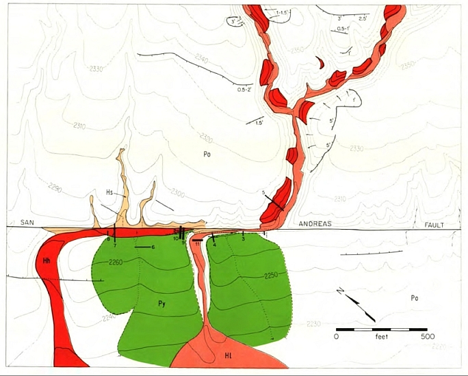
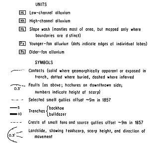
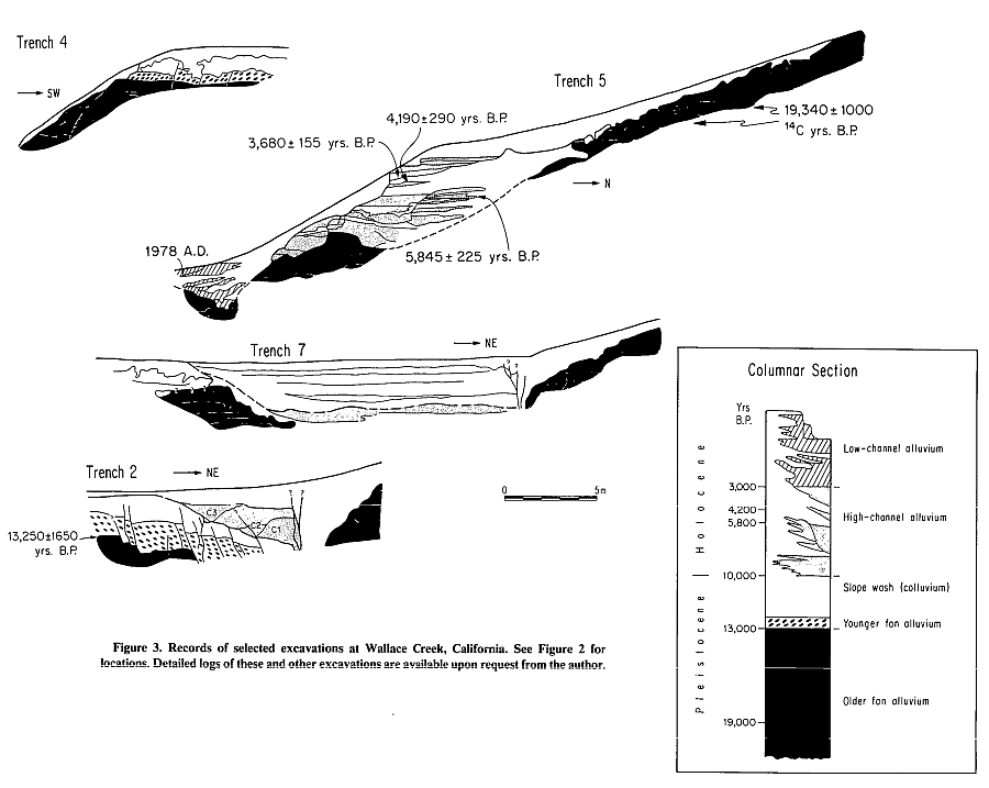
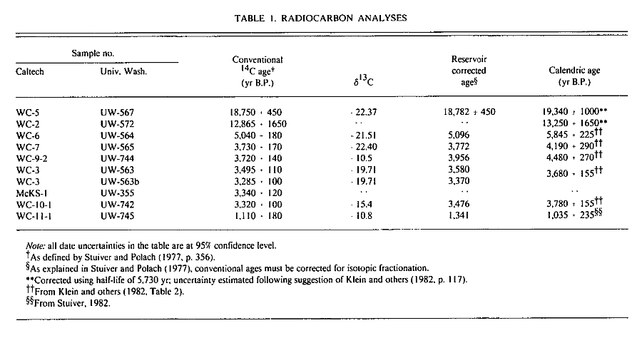
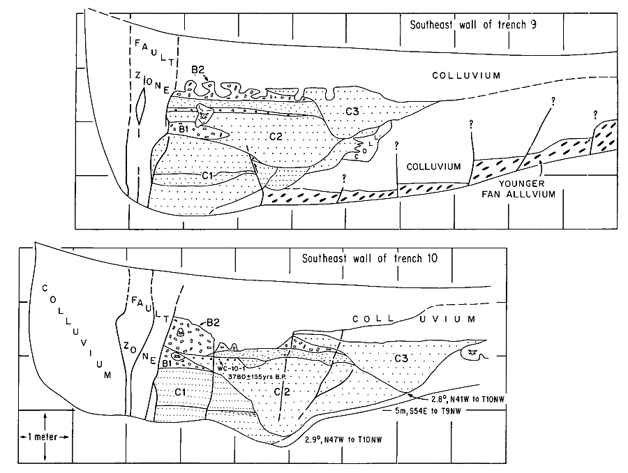
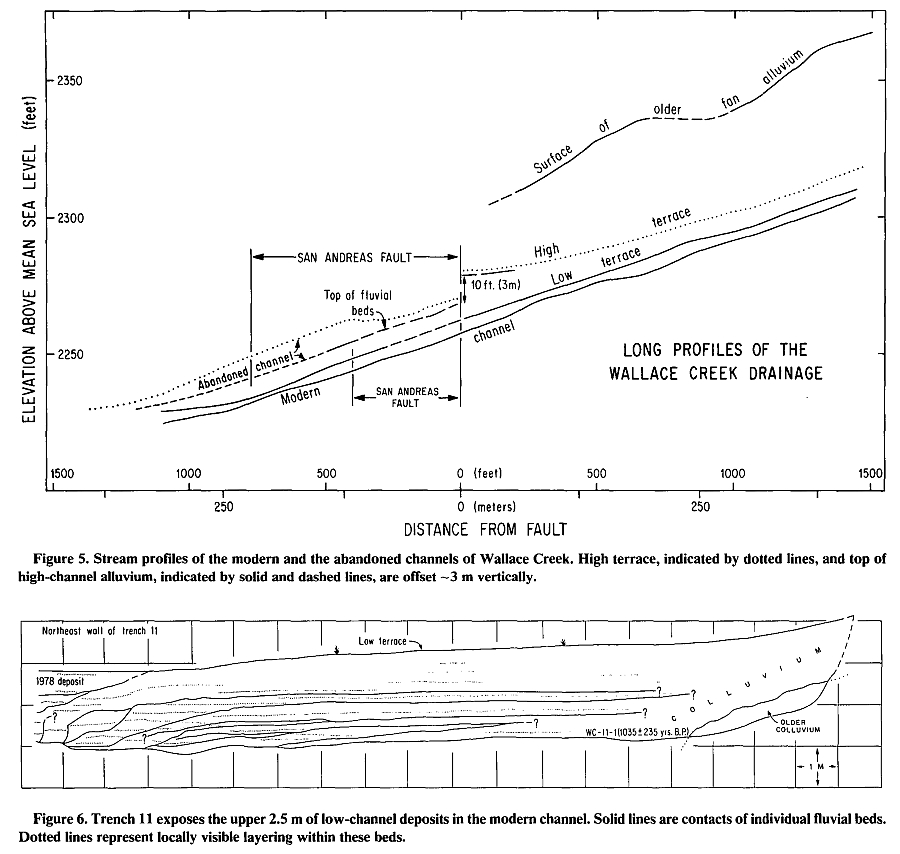
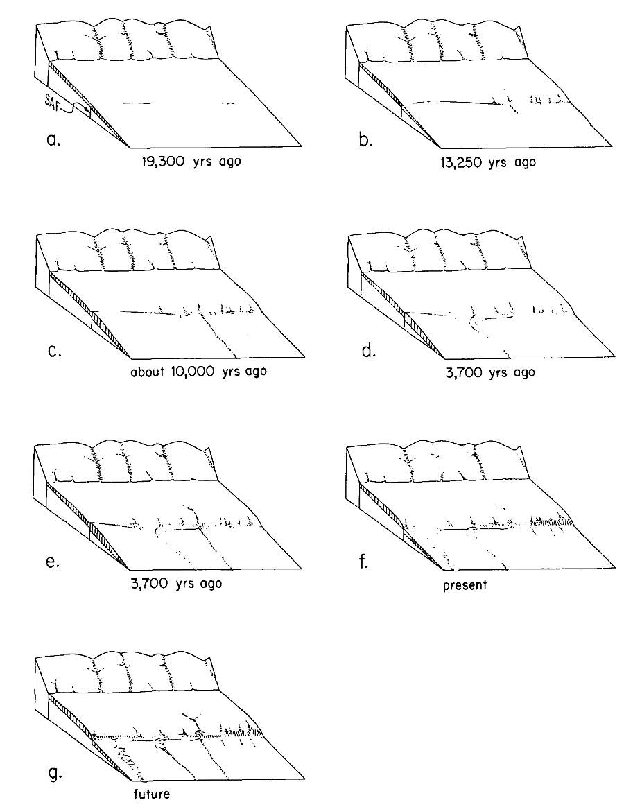
![[IMAGE]](fig_8.jpg) 1a
1a
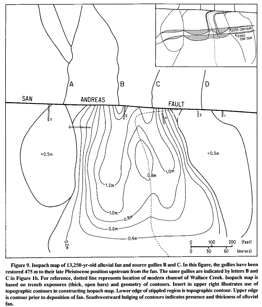 Trench 2 (Fig. 3) exposes the sediments of the
fan near its apex. There, the sediments constitute
a 1.3-m-thick bed of well-sorted, imbricated
sandy gravel. The gravel is composed of tabular
pebbles of diatomaceous Tertiary marine mudstone. Imbrication of these tabular pebbles
clearly indicates a flow direction toward the
southwest. The source of the alluvial fan thus
must be on the opposite side of the San Andreas
fault . Although the fan is composed of three
discrete beds in trench 2 (see detailed log of
trenches, available from author), the lack of
bioturbation or weathering of the two horizons
between these beds suggests that the fan was
deposited very rapidly, perhaps in a matter of a
few decades or less.
The deposit overlies a massive, poorly sorted
sandy loam that represents either a colluvial unit
or an alluvial deposit that was extensively bioturbated prior to burial. The unit probably lay at
the ground surface for a long time prior to burial
by the alluvial fan. The presence of charcoal
pebbles and granules in this unit, no more than a
centimetre or two beneath the base of the fan,
suggests that a range fire occurred just prior to
deposition of the fan. The charcoal certainly
would have been oxidized if it had not been
buried deeply very soon after its formation. Erosion of the fan materials from their source within
the burned area may have been a direct result of
the fire, which removed protective vegetative
cover from the ground surface. The charcoal age
of 13,250 ± 1,650 yr B.P. thus represents the age
of the basal unit of the overlying alluvial fan.
If the source of the younger fan sediments
were Wallace Creek, the fan would be offset a
mere 128 m. This would imply that the fault
was inactive between about 13,000 yr and about
3700 yr B.P., because we have just shown that
128 m of slip has occurred since about 3700 yr
B.P. Such a long period of dormancy along the
San Andreas fault seems very unlikely to us, and
so we seek a source for the younger fan that is
farther to the southeast.
The volume of the fan is -25,000 m3. Candidates for the source gully (or gullies) must have
total eroded volumes at least as great as this and
preferably somewhat larger, because some of the
material transported out of the source region
must have been carried beyond the alluvial fan
as suspended load and bedload.
Given this constraint, only two plausible
sources for the fan exist within 1 km of Wallace
Creek. The first is a solitary channel -730 m
southeast of the fan apex (E in Fig. 1). This
channel originates in the Temblor Range but
drains a much smaller area than Wallace Creek.
If this is the source, an average slip rate of -63
mm/yr for the period 13,250 to 3700 yr B.P. is
calculated:
Trench 2 (Fig. 3) exposes the sediments of the
fan near its apex. There, the sediments constitute
a 1.3-m-thick bed of well-sorted, imbricated
sandy gravel. The gravel is composed of tabular
pebbles of diatomaceous Tertiary marine mudstone. Imbrication of these tabular pebbles
clearly indicates a flow direction toward the
southwest. The source of the alluvial fan thus
must be on the opposite side of the San Andreas
fault . Although the fan is composed of three
discrete beds in trench 2 (see detailed log of
trenches, available from author), the lack of
bioturbation or weathering of the two horizons
between these beds suggests that the fan was
deposited very rapidly, perhaps in a matter of a
few decades or less.
The deposit overlies a massive, poorly sorted
sandy loam that represents either a colluvial unit
or an alluvial deposit that was extensively bioturbated prior to burial. The unit probably lay at
the ground surface for a long time prior to burial
by the alluvial fan. The presence of charcoal
pebbles and granules in this unit, no more than a
centimetre or two beneath the base of the fan,
suggests that a range fire occurred just prior to
deposition of the fan. The charcoal certainly
would have been oxidized if it had not been
buried deeply very soon after its formation. Erosion of the fan materials from their source within
the burned area may have been a direct result of
the fire, which removed protective vegetative
cover from the ground surface. The charcoal age
of 13,250 ± 1,650 yr B.P. thus represents the age
of the basal unit of the overlying alluvial fan.
If the source of the younger fan sediments
were Wallace Creek, the fan would be offset a
mere 128 m. This would imply that the fault
was inactive between about 13,000 yr and about
3700 yr B.P., because we have just shown that
128 m of slip has occurred since about 3700 yr
B.P. Such a long period of dormancy along the
San Andreas fault seems very unlikely to us, and
so we seek a source for the younger fan that is
farther to the southeast.
The volume of the fan is -25,000 m3. Candidates for the source gully (or gullies) must have
total eroded volumes at least as great as this and
preferably somewhat larger, because some of the
material transported out of the source region
must have been carried beyond the alluvial fan
as suspended load and bedload.
Given this constraint, only two plausible
sources for the fan exist within 1 km of Wallace
Creek. The first is a solitary channel -730 m
southeast of the fan apex (E in Fig. 1). This
channel originates in the Temblor Range but
drains a much smaller area than Wallace Creek.
If this is the source, an average slip rate of -63
mm/yr for the period 13,250 to 3700 yr B.P. is
calculated:
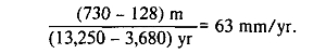
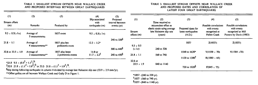
 The northwestern 30 km of the south-central
segment (Fig. 10) must also share the long-term
average slip rate of Wallace Creek. No diversion
of a large fraction of the Wallace Creek rate
along other structures is plausible. The only
known major active(?) fault nearby is the San
Juan Hill fault , which runs 3 to 14 km west of
and subparallel to the San Andreas from about
Cholame to Wallace Creek (Jennings and others, 1975). Its rate of slip is probably no more
than a few millimetres per year.
A second explanation fcr the different behavior of the three parts of the south-central segment is based on the hypothesis that each part is
imbued with a different strength. If, for reasons
of geometry or rock properties, the cent'al 160
km of the segment were 2 or 3 times stronger
than the 2 other parts, 2 or 3 times a;, much
elastic loading of the adjacent crustal blocks
would be necessary before failure occurred.
Each failure thus would result in two to three
times as much slippage as on the two adjacent
parts. Such an explanation is compatible with
our judgments that (1) slip rate does not vary
greatly along the south-central segment, and
(2) large earthquakes are more frequent at
Pallett Creek than at Wallace Creek.
Table 3 lists our best estimates of the dates of
large earthquakes at Wallace Creek and proposed correlations with large earthquakes that
have been directly dated at Pallett Creek (Sieh,
in press) and at Mill Potrero (Davis, 1983). The
capital letters in Figure 10 reflect our best judgment regarding correlation of the latest events at
Wallace Creek, Pallett Creek, and Mill Potrero.
Event X at Pallett Creek (A.D. 1720 ± 50) has
no correlative at Wallace Creek, although Davis
(1983) discovered evidence for and dated a relatively small slip event at Mill Potrero that may
well be event X. Event V at Pallett Creek occurred about A.D. 1550, which is about the time
we estimate that the last prehistoric event at
Wallace Creek occurred, and also about the
time of a large slip event that Davis (1983) discovered at Mill Potrero. Similarly, events R and
F at Pallett Creek occurred at about the time we
estimate that the third and fourth events occurred at Wallace Creek.
On the basis of the foregoing discussion, we
judge that the central 160 km of the southcentral segment of the San Andreas fault is un-
likely to generate a great earthquake for at least
another 100 yr. Recurrence intervals appear to
be in the range of 250 to 450 yr, and yet the time
elapsed since the great earthquake of 1857 is
only 127 yr. Slip during the latest 3 great earthquakes has been 7 to 12.3 m, and yet we suspect
that only a little more than 4 m of potential slip
has been stored in the past 127 yr.
The southeastern 90 km and the northwestern
30 km of the south-central segment are good
candidates for producing a large earthquake
within the next several decades. Geomorpho-
logie measurements seem to indicate that 3 to
4.5 m of slip is characteristic during large events,
and >4 m of potential slip may well have been
stored in the adjacent crustal blocks since 1857.
Based on studies at Pallett Creek, the probability
of a great event along the southeastern 90 km of
the south-central segment within the next 50 yr
is between 26% and 98% (Sieh, in press).
The northwestern 30 km of the south-central
segment (Fig. 10) must also share the long-term
average slip rate of Wallace Creek. No diversion
of a large fraction of the Wallace Creek rate
along other structures is plausible. The only
known major active(?) fault nearby is the San
Juan Hill fault , which runs 3 to 14 km west of
and subparallel to the San Andreas from about
Cholame to Wallace Creek (Jennings and others, 1975). Its rate of slip is probably no more
than a few millimetres per year.
A second explanation fcr the different behavior of the three parts of the south-central segment is based on the hypothesis that each part is
imbued with a different strength. If, for reasons
of geometry or rock properties, the cent'al 160
km of the segment were 2 or 3 times stronger
than the 2 other parts, 2 or 3 times a;, much
elastic loading of the adjacent crustal blocks
would be necessary before failure occurred.
Each failure thus would result in two to three
times as much slippage as on the two adjacent
parts. Such an explanation is compatible with
our judgments that (1) slip rate does not vary
greatly along the south-central segment, and
(2) large earthquakes are more frequent at
Pallett Creek than at Wallace Creek.
Table 3 lists our best estimates of the dates of
large earthquakes at Wallace Creek and proposed correlations with large earthquakes that
have been directly dated at Pallett Creek (Sieh,
in press) and at Mill Potrero (Davis, 1983). The
capital letters in Figure 10 reflect our best judgment regarding correlation of the latest events at
Wallace Creek, Pallett Creek, and Mill Potrero.
Event X at Pallett Creek (A.D. 1720 ± 50) has
no correlative at Wallace Creek, although Davis
(1983) discovered evidence for and dated a relatively small slip event at Mill Potrero that may
well be event X. Event V at Pallett Creek occurred about A.D. 1550, which is about the time
we estimate that the last prehistoric event at
Wallace Creek occurred, and also about the
time of a large slip event that Davis (1983) discovered at Mill Potrero. Similarly, events R and
F at Pallett Creek occurred at about the time we
estimate that the third and fourth events occurred at Wallace Creek.
On the basis of the foregoing discussion, we
judge that the central 160 km of the southcentral segment of the San Andreas fault is un-
likely to generate a great earthquake for at least
another 100 yr. Recurrence intervals appear to
be in the range of 250 to 450 yr, and yet the time
elapsed since the great earthquake of 1857 is
only 127 yr. Slip during the latest 3 great earthquakes has been 7 to 12.3 m, and yet we suspect
that only a little more than 4 m of potential slip
has been stored in the past 127 yr.
The southeastern 90 km and the northwestern
30 km of the south-central segment are good
candidates for producing a large earthquake
within the next several decades. Geomorpho-
logie measurements seem to indicate that 3 to
4.5 m of slip is characteristic during large events,
and >4 m of potential slip may well have been
stored in the adjacent crustal blocks since 1857.
Based on studies at Pallett Creek, the probability
of a great event along the southeastern 90 km of
the south-central segment within the next 50 yr
is between 26% and 98% (Sieh, in press).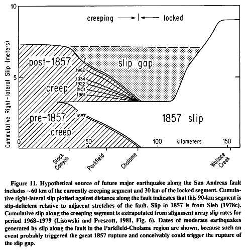 We assume that creep rates northwest of Cholame have been constant for the past few
hundred years, so that the alignment array data
for the period 1968-1979 are representative of
the pre- and post-1857 creep rates. We also assume that Cholame has been the edge of the
creep zone throughout this period. In the century preceding 1857, 3 to 3.5 m of slip would
have accumulated by creep northwest of Slack
Canyon. Less slip would have accumulated by
creep, and perhaps during occasional moderate
earthquakes, between Slack Canyon and
Cholame.
In 1857, —3.5 m of slip occurred along the
30-km stretch of the fault southeast of Cholame,
and 9.5 m of slip occurred in the vicinity of
Wallace Creek. The sparse historical accounts
are compatible with our inference in Figure 11
that slippage during the earthquake decreased
northwestward from Cholame and died out near
Slack Canyon (Sieh, 1978c, p. 1423-1424).
Following 1857, creep resumed northwest of
Cholame. Northwest of Slack Canyon, —4.5 m
of slip now has accumulated at the full, longterm rate of loading of the fault (that is, 34
mm/yr). The 60-km-long section between Slack
Canyon and Cholame, however, has crept at
rates that are significantly lower than the loading
rate, and strain is being stored in the rocks adjacent to the fault there. Similarly, elastic strains
are accumulating in the rocks adjacent to the
locked portion of the fault, and the northernmost 30 km of this portion, which seems to fail
in 3- to 4-m slip events, may well be loaded
nearly to the point of failure.
We suggest that this northernmost part of the
locked segment and the southernmost part of the
creeping segment might fail in unison and produce a major earthquake. This hypothetical
event would be associated with —90 km of surface rupture and a maximum of-4.3 m of right-
lateral slip.
In discussing this hypothetical event, it is important to note that the great 1857 earthquake
seems to have originated in this region. Sieh
(1978a) documented that at least 2 moderate
foreshocks occurred in this vicinity about 1.5
and 2.5 hr prior to the main shock. Within the
past century, 5 moderate (M5.5 to 6) earthquakes have been produced by slippage along
the San Andreas fault northwest of Cholame.
Sieh (1978a) inferred that the 1857 foreshocks
emanated from a source similar to that which
produced these historical shocks. If this is true,
then the next moderate "Parkfield-Cholame"
earthquake might well be a foreshock of the
hypothetical major event described above.
We assume that creep rates northwest of Cholame have been constant for the past few
hundred years, so that the alignment array data
for the period 1968-1979 are representative of
the pre- and post-1857 creep rates. We also assume that Cholame has been the edge of the
creep zone throughout this period. In the century preceding 1857, 3 to 3.5 m of slip would
have accumulated by creep northwest of Slack
Canyon. Less slip would have accumulated by
creep, and perhaps during occasional moderate
earthquakes, between Slack Canyon and
Cholame.
In 1857, —3.5 m of slip occurred along the
30-km stretch of the fault southeast of Cholame,
and 9.5 m of slip occurred in the vicinity of
Wallace Creek. The sparse historical accounts
are compatible with our inference in Figure 11
that slippage during the earthquake decreased
northwestward from Cholame and died out near
Slack Canyon (Sieh, 1978c, p. 1423-1424).
Following 1857, creep resumed northwest of
Cholame. Northwest of Slack Canyon, —4.5 m
of slip now has accumulated at the full, longterm rate of loading of the fault (that is, 34
mm/yr). The 60-km-long section between Slack
Canyon and Cholame, however, has crept at
rates that are significantly lower than the loading
rate, and strain is being stored in the rocks adjacent to the fault there. Similarly, elastic strains
are accumulating in the rocks adjacent to the
locked portion of the fault, and the northernmost 30 km of this portion, which seems to fail
in 3- to 4-m slip events, may well be loaded
nearly to the point of failure.
We suggest that this northernmost part of the
locked segment and the southernmost part of the
creeping segment might fail in unison and produce a major earthquake. This hypothetical
event would be associated with —90 km of surface rupture and a maximum of-4.3 m of right-
lateral slip.
In discussing this hypothetical event, it is important to note that the great 1857 earthquake
seems to have originated in this region. Sieh
(1978a) documented that at least 2 moderate
foreshocks occurred in this vicinity about 1.5
and 2.5 hr prior to the main shock. Within the
past century, 5 moderate (M5.5 to 6) earthquakes have been produced by slippage along
the San Andreas fault northwest of Cholame.
Sieh (1978a) inferred that the 1857 foreshocks
emanated from a source similar to that which
produced these historical shocks. If this is true,
then the next moderate "Parkfield-Cholame"
earthquake might well be a foreshock of the
hypothetical major event described above.