Return
Abundant evidence indicates that the earth has been subjected to a massive number of impacts, including many large and catastrophic impacts. Such evidence is incompatible with the young earth timetable and human survival. Although many other lines of evidence also refute young earth theories, this readily understood impact evidence thoroughly and totally falsifies the young earth framework.
Impact Crater Evidences
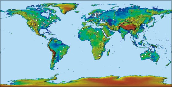
World Wide distribution of known Impact Craters
|
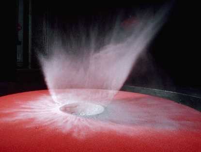
| Laboratory impact simulation. |
|
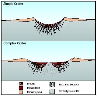
| Crater Types |
Here is a brief summary of the possible results.
Size 1--10 km: Objects in this size range are likely to cause severe global
effects and are theorized to be "species-busters". The crater
alone from such an impact will be 10--15 times larger than the object
itself and an ejecta blanket many times larger. They are portrayed as causing
world-wide crop failures from dust injected into the
atmosphere that could imperil civilization, and the largest-sized objects
could make the human species become extinct. Some secular scientists have theorized that
an impact 65 million years ago by an
object of 5--10 km in diameter was partially or
fully responsible for the extinction of half the living species of
animals and plants at the time, including the dinosaurs.
Size 100 m--1 km: Objects in this size range are likely to cause severe damage over a regional area, possibly as large as a continent (hence the name "continent-busters"). If they strike land, they will almost certainly produce a crater, while an ocean impact will generate large tidal waves. A 150 m object might produce a crater 3 km in diameter, an ejecta blanket 10 km in diameter, and a zone of destruction extending much farther out. For a 1 km impactor the zone of destruction might reasonably extend to cover countries. The death toll could be in the tens to hundreds of millions. A 1 km impactor could begin to have minor global consequences, including global cooling caused by vast amounts of dust in the atmosphere.
Size 10--100 m: Objects in this size range can produce devastation similar to that of an atomic blast (leading to them occasionally being called "city-busters"). Effects include severe damage to or collapse of standing buildings and the ignition of flammable materials leading to widespread fires. The radius over which such effects occur would vary depending upon the size and composition of the object, but could easily exceed 10 km. The Tunguska event, in Siberia, of 1908 is thought to have been from an object about 60 m in size; it led to trees being flattened out to 20 km and trees 40 km away being damaged. At the small end of this size range, objects about 10 m strike the Earth about once a decade. Fortunately, only the densest objects, those containing iron, survive to the surface; most of the objects of this size explode sufficiently high in the atmosphere that there are no effects (other than maybe a loud noise) on the ground. At the larger end of this size range, it is estimated that the Earth is struck several times a millennium or about 1 impact every 100--200 yr.
See Appendix A for a table of known impact locations, top 15 only.
See Appendix B for details of the Chesapeake Bay crater by USGS
Impact Craters Challenge Earth Age Theories
|
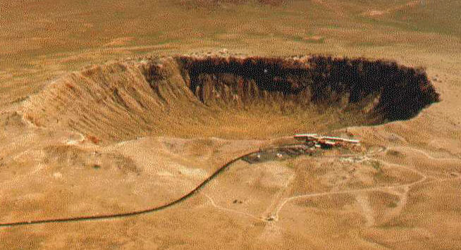
|
Barringer Crater in AZ, approx. 1.2 km (4000 ft) wide. |
An early attempt to deal with the crater evidence was made by the "father of modern creationism," Henry M. Morris, who suggested that lunar and Martian craters might represent battle scars of a cosmic war between angels and Satan (Morris, 1972; Spears, 2006). In recent years most young earth theorists seem to have distanced themselves from Morris's fanciful proposal. Recognizing the scientific evidence that the craters represent millions of real meteorite impacts, some have attempted to accommodate them within the young earth timetable by proposing that virtually all such impacts occurred during one or two major bombardment episodes during the creation week, and/or the "Flood year."
In an article entitled "A biblically-based cratering theory" on the "Answers in Genesis" website Danny Faulkner writes:
If this latest impact catastrophe is equated with the biblical Flood, then it follows that
the Flood on earth was accompanied by large impacts. The time frame of the Flood constrains
the period over which the impacts could have occurred to no more than a few months less
than a year. Depending upon the model adopted, the impacts may have happened over just a
few days (Faulkner, 2006).
|
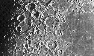
| Lunar craters |
However, Faulkner and other young earth theorists do not seem to appreciate the implications of such massive bombardment within the young earth time frame. Approaching 200 major craters have been documented to date in the geologic record, and this is undoubtedly a small fraction of the actual number, since most would have been obliterated by tectonic actions and erosion, or totally hidden under sediments. In 2017 at least 190 were confirmed, with 10 greater than 200 km proposed but unconfirmed. We can get a good idea of the number of meteorite impacts on earth by examining the planets in our solar system which largely have less of such geologic activity, such as mercury, mars, and venus, as well as earth's moon.
Despite having a surface area only about 1/10 that of earth, our moon
is covered by millions of craters. About a half a million have
diameters greater than 1 km. The largest is about 360 kilometers (200
miles) wide; dozens are over 150 km in width. Note that the Chicxulub
crater on earth, believed to have contributed to the K-T extinction
when dinosaurs and many other life forms went extinct, is about 160 km
wide, thought to have been made by a meteorite approximately 10 - 15 km
wide. Many such impacts are thought to have occurred during an intense
bombardment period about 3.9 billion years ago. On the moon, this
resulted in the formation of 1700 lunar craters 100 kilometers wide or
larger, defacing about 80% of the Moon's crust (Cohen, 2001). As Cohen
notes: "The Earth would not have escaped a similar beating during this
time." Indeed, since the earth's surface is over 13 times that of the
moon, we can estimate that over 20,000 major sized meteors (each capable of
making 100 km or larger crater) would have impacted the earth during
this early bombardment episode alone. If compressed into a "Flood
year," that amounts to over 50 major impacts a day. If further
condensed into a "few days" as Faulkner suggests, the earth would have
received several hundred major impacts each day. Yet, surprisingly
Faulkner does not deal with the implications of this for human
survival.
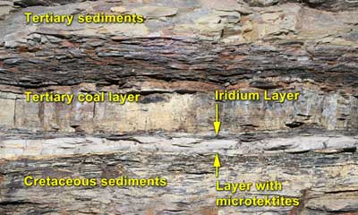
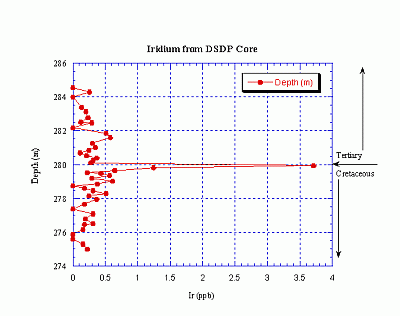
The resulting debris from Chicxulub that ejected into high altitudes spread around the globe and settled as a thin layer of material that marks the precise K/T boundary between the last rocks of the Cretaceous Period and the first sediments formed in the younger (overlying) Tertiary Period. The deposits contain Iridium, a metallic element related to Platinum present in some meteorites, in amounts far greater than can be accounted for by volcanic sources or other terrestrial rocks.
It might be argued that impacts in deep water would be less destructive than those on land. However, even a few such impacts within a year or less would be devastating, as trillions of tons of debris (dust, gases and water vapor) would be thrown into the atmosphere when the object vaporized. This would likely result in a prolonged period of darkened skies, significantly lower global temperatures, acid rain, and what has been called global "nuclear winter" conditions. The impact would also result in earthquakes, tremendously violent winds, and immense tidal waves, thoroughly engulfing and destroying any Ark. Even a single 10 km wide meteorite (roughly the size of the one which formed the Chicxulub crater), would create tsunamis several hundred meters high (Strobel, 2006). Imagine thousands of such impacts, plus even larger ones, all occurring within a year or less. No human life, in or out of an Ark, could have withstood such an onslaught.
It is very difficult to explain how millions of aquatic species--including many sensitive to specific ecological conditions, including narrow ranges of temperature, salinity, acidity, turbidity--survived a violent global Flood. Adding the implications of massive meteorite bombardment further undermines the plausibility of their model.
Perhaps realizing these difficulties, some young earth theorists have proposed that virtually all of the impacts occurred during the "creation week." However, this entails other major problems, including:
1. The Biblical description of the garden of Eden and God's declaration that the creation was "very good" hardly seem consistent with the idea that massive bolide bombardment was taking place during this time. And especially since some have the interpretation that the creation was "perfect" prior to the sin of Adam and Eve in the garden, even though NO where does the Bible directly so state.
2. One might propose that all the bombardment took place the same 24 hour day the moon was created on day 4 as per the interpretation by many young earth creationists, before life forms were created on days 5 and 6. However, not only does a lot of evidence contradict a one-day only bombardment, environmental conditions would hardly seem to have been favorable to life the very next day. Indeed, such a massive bombardment would make the earth a smoldering inferno.
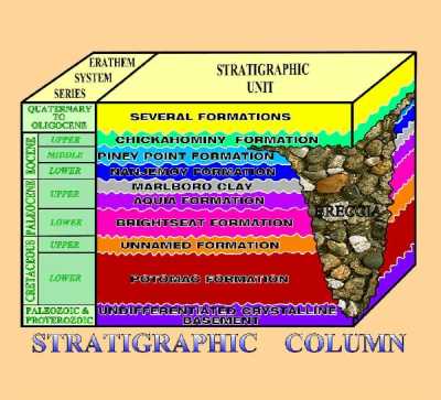
3. Evidence of large craters occurs in different parts of the geologic record on earth, including Paleozoic and Cenozoic strata. Most creationists interpret these not as creation-week rocks, but as Flood or post-Flood deposits. Nearly three quarters of the impacts sites known today were into sedimentary or a mixture of sedimentary strata overlying crystalline basement and thus would be interpreted to be into Flood or post-Flood deposits by some young earth theorists.
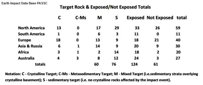
Note that 73% (136) of the total is into sedimentary material and 63% of those into sedimentary material are exposed on the surface and thus in upper sedimentary material penetrating to different depths depending upon the size of the crater!! All of these impacts happening after the flood would be catastrophic to life on the earth !! Some want to put most all of the impacts into a six day creation week, but the data showing a very high percentage in upper sedimentary layers and exposed to the surface refutes this proposal, if as YEC's propose, the flood was a global former of this sedimentary material.
4. Many craters on the moon and other bodies show evidence of impacts over a significant period of time; many are overlapped and subdued by volcanic activity (Herres and Hartmann, 2004). Radiometric dates on lunar samples support the great age of the impacts and their formation over millions of years--certainly not within a literal earth week. In fact, radiometric dating methods indicate that the known earth impact sites range through out the history of the earth from the modern period less than about 600 years ago until 2,400 million years ago.
5. Two impact craters in Bible land are very telling!
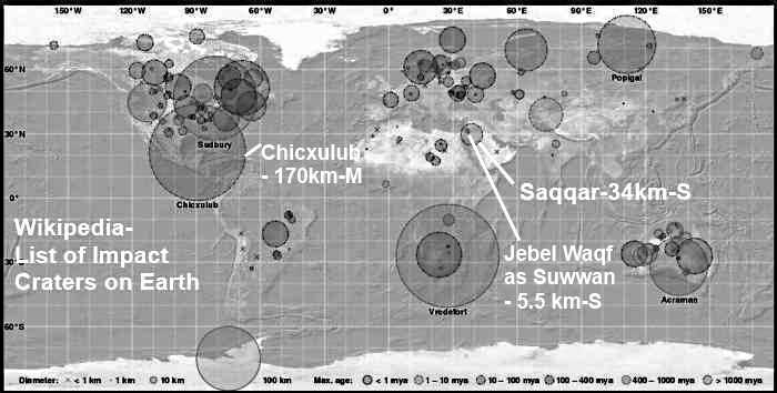
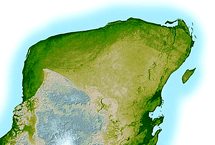
Saqqar of north western Saudi Arabia which is entirely into sedimentary material and at 34 km diameter would have a large destructive effect on the area!! At about 400m depth and partially exposed on one edge it's signature pattern is as shown below as measured using airborne gravimetry instruments. The structure is formed in CambrianDevonian siliciclastics and is unconformably overlain by undeformed Cretaceous and Paleogene sediments. A small outcrop in the center of Saqqar may represent the exposed, albeit eroded, tip of the central crater uplift. A 34 km crater could have an ejecta blanket 110 km in diameter and with a zone of destruction extending further out, possibly covering many adjacent countries. Could be characterized as a "continent-buster" and could have some global consequences including global cooling caused by large amounts of dust thrown into the atmosphere. If it happened before a global massive catastrophic flood that formed this sedimentary strata its signature would not exist !

Jebel Waqf as Suwwan located in eastern Jordan, due east of southern end of the Dead sea, is listed as 5.5 km in diameter, exposed on the surface, and impacted into sedimentary Cretaceous limestone. It is located well within the area that would have been detrimentally influenced by an earlier Saqqar impact. Both of these craters existing in the geologic record, one above the other, indicate that they would have to have both happened after the theorized global flood that is proposed to have formed much of the sedimentary strata !!
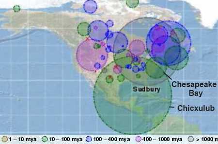
Looking at North America we see many overlapping impact destruction areas at varying depths in the sedimentary
layers. Chicxulub being much later than Sudbury and Chesapeake Bay more recent.
6. From the following verses:
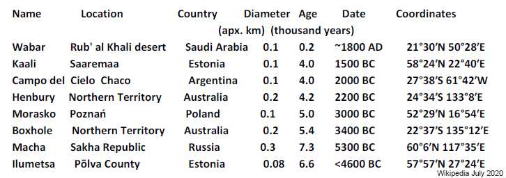
Thus we would expect that there just would not be any catastrophic impacts after the flood to hinder animals and humans from multiplying, and that is just what the data for craters less than 10,000 years old as presented in Wikipedia shows !Gen 8:16 "Go out from the ark, you and your wife, and your sons and your sons' wives with you.
Gen 8:17 Bring out with you every living thing that is with you of all flesh--birds and animals and every creeping thing that creeps on the earth--that they may swarm on the earth, and be fruitful and multiply on the earth."
Gen 8:22 While the earth remains, seedtime and harvest, cold and heat, summer and winter, day and night, shall not cease." (ESV
Old earth theories allow for long periods of time for the large catastrophic impacts to happen before the recorded history of mankind !!
Ironically, some creationists have tried to use meteorite evidence as an argument for a young earth, based on the supposed rarity of meteorites in the fossil record (Stevenson, 1975). However, the argument is entirely groundless, as it ignores all of the following:
1. The many physical factors and processes on earth which destroy or obscure meteorites in the geologic record (Thompson, 2005). There would be countless more if it weren't for Earth's constant remodeling. Volcanoes erupt and erosion washes over the planet's surface continually hiding the evidence of many craters. They are selectively found mostly in the stable interior regions of continents. Few underwater craters have been discovered because of the difficulty of surveying the sea floor, and the rapid rate of change of the ocean bottom with volcanics, plate tectonics subduction and mid-ocean ridge divergence.
2. The now known evidences from craters and meteoritic dust in the geologic record (Matson, 1994; Thompson, 2006).
It was not until the 1960s that the existence of impact craters began to be widely accepted. And more than 50 had been tentatively
identified by 1970. And obviously the list will grow with time.
3. The abundant evidence from the moon, Mars, and other bodies in our solar system indicating massive numbers of impacts. No plausible argument has been advanced as to why the earth would have escaped similar bombardment.
At one time many young earth theorists also argued that the amount of meteoritic dust on the moon was evidence for a young solar system. However, the argument was shown to be seriously flawed (Dalrymple, 1984), and as has since been acknowledged by many in the young earth community (Snelling and Rush, 1993). In fact, when evidence of dust influx rates is examined closely, it actually provides further support for conventional geologic ages (Stear, 2005).
Conclusion:
Abundant evidence indicates that the earth has been subjected to a massive number of impacts, including many large and catastrophic impacts. Such evidence is incompatible with the young earth timetable and human survival. Although many other lines of evidence also refute young earth theories, this readily understood impact evidence thoroughly and totally falsifies the young earth framework.
References
Britt, Robert Roy, 2006, Giant Crater Found: Tied to Worst Mass Extinction Ever. Space.com article at: http://www.space.com/scienceastronomy/060601_big_crater.html.
Cohen, Barbara, 2001. Lunar Meteorites and the Lunar Cataclysm. University of Tennessee website at: http://www.psrd.hawaii.edu/Jan01/lunarCataclysm.html
Dalrymple, G. Brent, 1984. "How Old Is the Earth? A Reply to 'Scientific Creationism'", in Proceedings of the 63rd Annual Meeting of the Pacific Division, AAAS Volume 1, Part 3, California, AAAS. pp. 66-131. http://www.talkorigins.org/faqs/dalrymple/how_old_earth.html
Faulkner, Danny, 2006, web article at: http://www.answersingenesis.org/tj/v13/i1/crater.asp Originally published in the Technical Journal 13(1):100-104, April 1999
Herres, Gregg, and William K. Hartmann, 2004. Web article at: http://www.psi.edu/projects/mgs/cratering.html
Matson, Dave E. 1994. "How Good are those Young Earth Arguments?" Web page at: http://www.kent-hovind.com/matson/1proofs.htm#3
Morton, Glenn. 2003. "Meteor Craters and the Flood Year." Web article at: http://home.entouch.net/dmd/meteors.htm
Morris, Henry M. 1972, The Remarkable Birth of Planet Earth.
Mory, Arthur J. et al, "Woodleigh, Carnarvon Basin, Western Australia: a New 120 Km Diameter Impact Structure," Earth and Planetary Science Letters 177(2000):119-128, p. 127. *
Salleh, Anna, Killer crater may have spawned Australia, ABC Science Online article at: http://www.abc.net.au/science/news/stories/s1654155.htm
Snelling, Andrew A. and David E Rush. 1993. Moon dust and the age of the solar system. Technical Journal. Vol 7, NO. 1, p/ 2-42. Web version at: http://www.answersingenesis.org/tj/v7/i1/moondust.asp
Spears, John, 2006, web article at: http://home.austarnet.com.au/stear/www_of_creationism_craters.htm
Stear, John, 2005. A dusty Young Earth Argument Backfires. Web article at: http://www.geocities.com/earthhistory/idp.htm?200620
Steveson, Peter A. "Meteoric Evidence or a Young Earth," Creation Research Quarterly, Vol. 12, June, 1975, pp. 23-25.
Strobel, Nick, 2006, web article "Effects of an Asteroid Impact on Earth" at: http://www.astronomynotes.com/solfluf/s5.htm
Tompson, Tim. 2005. Web article at: http://www.tim-thompson.com/resp4.html
Tompson, Tim. 2006. Meteorite Dust and the Age of the Earth. Web article at: http://www.talkorigins.org/faqs/moon-dust.html
Web article at University of Tennessee Dept of Physics and Astronomy website: http://csep10.phys.utk.edu/astr161/lect/meteors/impacts.html
Sharpton, Virgil L. 1995, Chicxulub Impact Crater Provides Clues to Earth's History, Earth in Space, Vol. 8, No. 4, December 1995, p. 7.
( --------- * In so far as the age of the Woodleigh impact is constrained between the Early Permian and Early Jurassic, given the likely environmental consequences of an impact of this magnitude, it is possible that this event correlates with one of the two major extinctions during this time span, i.e., the end-Triassic (214 Ma) extinctions or the Permian-Triassic boundary (247 Ma) extinction. Arthur J. Mory et al, "Woodleigh, Carnarvon Basin, Western Australia: a New 120 Km Diameter Impact Structure," Earth and Planetary Science Letters 177(2000):119-128, p. 127
(Above portions copied from http://paleo.cc/ce/craters.htm and edited to add information.)
Appendix B
|
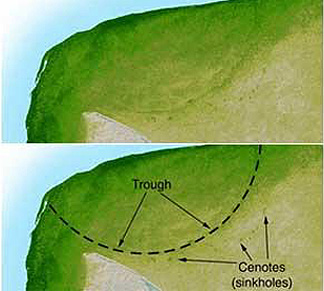
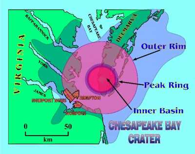 In order to fully appreciate the consequences of the Chesapeake Bay
impact, we need to understand what the crater is like, and how we know
it is there. It is the larger of two craters recently discovered on the
US East Coast by Wylie Poag and his colleagues. Both were estimated to be formed 35
million years ago in the late Eocene epoch of geological time. That's
about half as old as the dinosaur extinction. The crater is located
approximately 200 km southeast of Washington, D.C., and is buried
300-500 meters beneath the lower part of Chesapeake Bay, its
surrounding peninsulas, and the inner continental shelf of the Atlantic
Ocean. There is, however, much telltale geological evidence of the
impact.
In order to fully appreciate the consequences of the Chesapeake Bay
impact, we need to understand what the crater is like, and how we know
it is there. It is the larger of two craters recently discovered on the
US East Coast by Wylie Poag and his colleagues. Both were estimated to be formed 35
million years ago in the late Eocene epoch of geological time. That's
about half as old as the dinosaur extinction. The crater is located
approximately 200 km southeast of Washington, D.C., and is buried
300-500 meters beneath the lower part of Chesapeake Bay, its
surrounding peninsulas, and the inner continental shelf of the Atlantic
Ocean. There is, however, much telltale geological evidence of the
impact.
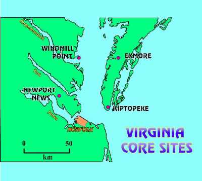
 The first evidence of a bolide impact on the East Coast came to
light in 1983. Wylie Poag was serving as Co-Chief Scientist on the
drill ship Glomar Challenger during Leg 95 of the National Science Foundation's Deep Sea
Drilling Project. At an offshore drill site 120 km east of Atlantic
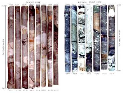
City, NJ, the scientific party of Leg 95 recovered a core
containing sedimentary debris diagnostic of a bolide impact. This
figure focuses on that discovery, and introduces some key terminology.
Shown here in great exaggeration, is the Glomar Challenger
drilling into the sedimentary beds that make up the seaward edge of the
continental shelf. The continental shelf is represented as a stack of
sedimentary beds, displayed on a seismic reflection profile. The
seismic profile is a type of sea floor sonogram. The survey ship
sends a series of sound waves into the sea floor. As each wave
encounters the boundaries between individual beds, part of the wave is
reflected back to a recording instrument. These reflections are
digitized and processed by computer to produce the seismic profile. The
profile shows the thickness, depth, and spatial orientation of each
bed, and allows one to determine the best drill site for solving a
particular geological problem. For example, we see here that the yellow
bed is tilted seaward, and has been fractured. The eastern block has
moved downward along the fracture plane relative to the western block.
This fracture plane is called a fault. At the lower end of the drill
pipe, the drill bit is located near the crest of a folded bed.
The first evidence of a bolide impact on the East Coast came to
light in 1983. Wylie Poag was serving as Co-Chief Scientist on the
drill ship Glomar Challenger during Leg 95 of the National Science Foundation's Deep Sea
Drilling Project. At an offshore drill site 120 km east of Atlantic
City, NJ, the scientific party of Leg 95 recovered a core
containing sedimentary debris diagnostic of a bolide impact. This
figure focuses on that discovery, and introduces some key terminology.
Shown here in great exaggeration, is the Glomar Challenger
drilling into the sedimentary beds that make up the seaward edge of the
continental shelf. The continental shelf is represented as a stack of
sedimentary beds, displayed on a seismic reflection profile. The
seismic profile is a type of sea floor sonogram. The survey ship
sends a series of sound waves into the sea floor. As each wave
encounters the boundaries between individual beds, part of the wave is
reflected back to a recording instrument. These reflections are
digitized and processed by computer to produce the seismic profile. The
profile shows the thickness, depth, and spatial orientation of each
bed, and allows one to determine the best drill site for solving a
particular geological problem. For example, we see here that the yellow
bed is tilted seaward, and has been fractured. The eastern block has
moved downward along the fracture plane relative to the western block.
This fracture plane is called a fault. At the lower end of the drill
pipe, the drill bit is located near the crest of a folded bed. 
 This suggested a common origin for the rubble bed and the New Jersey
tektite layer. So we looked for shock-altered minerals in the rubble
bed. Sure enough, we found trace amounts of shocked quartz and bits of
melt-rock in the rubble bed at each core site. Now we had diagnostic
evidence that the rubble bed resulted from a bolide impact. But we
still could not pinpoint the location of the source crater.
This suggested a common origin for the rubble bed and the New Jersey
tektite layer. So we looked for shock-altered minerals in the rubble
bed. Sure enough, we found trace amounts of shocked quartz and bits of
melt-rock in the rubble bed at each core site. Now we had diagnostic
evidence that the rubble bed resulted from a bolide impact. But we
still could not pinpoint the location of the source crater. 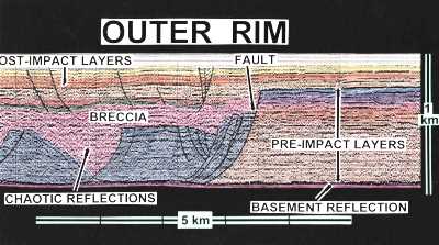 Here is a seismic profile which shows,
in cross section, the structure of the outer rim of the crater. Along
the base of the profile is a prominent reflection separating the purple
bed from the brown bed. The purple bed is composed of granite and
granite-like rocks, which we call crystalline basement. The basement
rocks are much denser than the sedimentary layers above it, and this
produces the strong basement reflection. The stack of horizontal
reflections to the right, between the purple and blue layers, represent
the normal sedimentary beds that existed here when the bolide struck.
The top of the blue bed represents the ancient sea-floor at the time of
the impact. As we look to the left on this profile, however, these
horizontal reflections are truncated by a series of faults, and the
orderly stacking of beds is disrupted. The blue units are large blocks
that have slumped off the crater's outer wall, and have slid to the
left into the annular trough. We can still see some organized
reflections in these blocks; some remain horizontal, but others are
diagonal, indicating that the blocks have rotated. The pink breccia
section is characterized by disorganized or chaotic reflections caused
by the jumble of clasts it contains. On top of the breccia are
horizontal reflections from the youngest beds, which accumulated during
the estimated past 35 million years since the bolide struck.
Here is a seismic profile which shows,
in cross section, the structure of the outer rim of the crater. Along
the base of the profile is a prominent reflection separating the purple
bed from the brown bed. The purple bed is composed of granite and
granite-like rocks, which we call crystalline basement. The basement
rocks are much denser than the sedimentary layers above it, and this
produces the strong basement reflection. The stack of horizontal
reflections to the right, between the purple and blue layers, represent
the normal sedimentary beds that existed here when the bolide struck.
The top of the blue bed represents the ancient sea-floor at the time of
the impact. As we look to the left on this profile, however, these
horizontal reflections are truncated by a series of faults, and the
orderly stacking of beds is disrupted. The blue units are large blocks
that have slumped off the crater's outer wall, and have slid to the
left into the annular trough. We can still see some organized
reflections in these blocks; some remain horizontal, but others are
diagonal, indicating that the blocks have rotated. The pink breccia
section is characterized by disorganized or chaotic reflections caused
by the jumble of clasts it contains. On top of the breccia are
horizontal reflections from the youngest beds, which accumulated during
the estimated past 35 million years since the bolide struck. 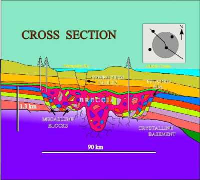 We can put all the core and seismic data together and produce a
two-dimensional cross section across the entire crater. A map view at
the upper right shows the location of the cross section relative to the
crater outline and the core sites. Outside the crater we see a stack of
gently dipping sedimentary beds lying on the granitic basement. The
bolide punched a deep hole through the sediments and into the basement
(the inner basin), fractured it to depths of 8 km, and raised the peak
ring around it. The sedimentary walls of the crater progressively
slumped in, widened the crater, and formed a layer of huge blocks on
the floor of the annular trough. The slump blocks were then covered
with the breccia. The entire bolide event, from initial impact to the
termination of breccia deposition lasted only a few hours or days. In
geological perspective, the 1.2 km-thick breccia is an instantaneous
deposit. The crater was then buried by additional sedimentary beds,
which accumulated during the following about 35 million years. The white
perpendicular columns beneath the drill derricks indicate the beds that
we cored.
We can put all the core and seismic data together and produce a
two-dimensional cross section across the entire crater. A map view at
the upper right shows the location of the cross section relative to the
crater outline and the core sites. Outside the crater we see a stack of
gently dipping sedimentary beds lying on the granitic basement. The
bolide punched a deep hole through the sediments and into the basement
(the inner basin), fractured it to depths of 8 km, and raised the peak
ring around it. The sedimentary walls of the crater progressively
slumped in, widened the crater, and formed a layer of huge blocks on
the floor of the annular trough. The slump blocks were then covered
with the breccia. The entire bolide event, from initial impact to the
termination of breccia deposition lasted only a few hours or days. In
geological perspective, the 1.2 km-thick breccia is an instantaneous
deposit. The crater was then buried by additional sedimentary beds,
which accumulated during the following about 35 million years. The white
perpendicular columns beneath the drill derricks indicate the beds that
we cored.