Helium in Gas Fields as Time Clocks:
An estimate of how long the Hugoton natural gas area
of southwestern Kansas has been collecting helium
It is not our purpose to estimate the age of the earth, but to obtain a rough estimate of the lower limit for the period of time for which the earth structure has allowed this area of Kansas to capture helium gas formed by radioactive decay under the bowl shaped structure of the Hugoton area. Based on the limits of the information available to us at this time and the assumptions we have had to make when the data available was not sufficient.
The Hugoton field is the largest natural gas field in North America and the second largest in the world. The Hugoton is only one of many gas fields in southwest Kansas (fig. 1) that have been important to Kansas since their development in the 1930's. The major gas fields of this area--Hugoton, Panoma, Bradshaw, Greenwood, and Byerly--have produced almost 27 trillion cubic feet of gas. The Hugoton and associated gas fields are part of a large, bowl--shaped structure that underlies most of southwest Kansas. This region is referred to as the Hugoton natural gas area. The area occupies approximately 5700 square miles and has over 6000 producing gas wells.
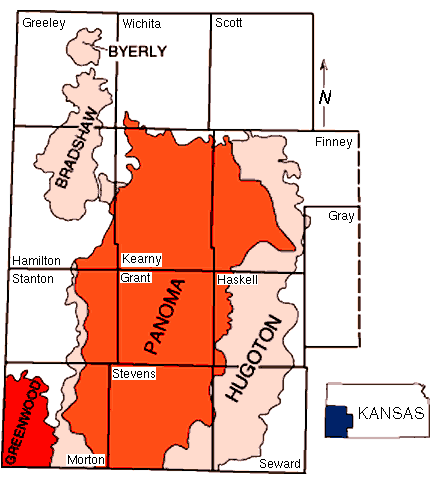 Fig1
Fig1The Hugoton gas area is in an area of moderate to high radon risk per the following figure, and this we will use as an indication of the relative radioactivity of the area. Since this area seems to have a radon rating of approximately 3.0 versus an national average of about 1.5, we will estimate that it has been producing helium due to crustal radioactive decay at a rate twice the normal of 0.0244 pounds per year per square mile, or 0.0488 pounds per year per square mile. The 0.0244 crustal helium production rate is calculated from the estimate of 2 x 10*6 atoms/cm*2/sec, "The current best estimate for the rate of flow of 4HE from the crust to the atmosphere", from "The Age of the Earth's Atmosphere: A Study of the Helium Flux through the Atmosphere" by Larry Vardiman, 1990.
USA RADON LEVELS (ppm)
 Fig 2
Fig 2
The 27 trillion cubic feet of gas production averaged over the approximately 5700 square miles gives an estimate of 4.74 x 10*9 cubic feet of natural gas per square mile. And if we assume that the natural gas in the area has been 50% depleted, we have an estimate of, in round numbers, 1.0 x 10*10 cubic feet per square mile of natural gas in the area. (We need an estimate that accounts for all the gas present, even that which is not economical for the gas companies to drill for or which present technology cannot extract, so this could be an under estimate.)
At approximately 0.5% helium content for the entire area we would have 5.0 X 10*7 cubic feet of helium per square mile and at .0104 pounds per cubic feet, we have an estimate of 5.2 x 10*5 pounds per square mile of helium.
At our helium generation rate of 0.0488 pounds per year per square mile this would give us our estimate of
10.7 x 10*6 years (10.7 million years).
We are assuming that the area has captured 100% of the generated helium, which would definitely seem to be incorrect, but to date we have no way to know the capture rate for a natural gas field. If we had a reasonable estimate of the capture percentage we would increase our time result proportionally. Therefore, we have estimates that are believed to be incorrect, some which would increase the resulting time value and some would decrease the resulting time value. One would hope that the believed inaccuracies would balance out and that the result is a "reasonable" estimate. The cost and time required to obtain better values would seem to be prohibitive, that is unless the government decides to fund the research.
Helium rich fields are considered as those fields with above 0.3% helium. Wells with up to 7% have been drilled, but typically the wells with higher helium percentages are on areas of geological uplifts where the amount of the concentration effect is more severe. For example a large number of the wells having high helium in Kansas are in the area of the Central Kansas Uplift. It is more difficult to estimate the total area of collection and concentration for such areas. However, we did so using the same method as above and the results are presented in the Summary table below. Areas of less severe concentration would seem to be more suited to our purposes, such as the Hugoton gas area, where wells typically have less than 1.0% helium (per gas well analyses provided by the Kansas Geological Survey, report ND-9).
As another rough verification of our results, let us look at a larger picture.

Fig 3
The United States has an estimated 250 x 10*9 cubic feet of known helium reserves from the major helium rich fields with a concentration of greater than 0.3%. At an estimated area of 15000 square miles, this gives us 1.66 x 10*7 cubic feet per square mile, or 1.7 x 10*5 pounds of helium per square mile. Again at out estimated helium generation rate of 0.0448 pounds per year per square mile we would have 3.9 x 10*6 (3.9 million years). But this is only the calculated time required to generate the estimated reserves and does not account for past production and helium in the areas in lower concentrations that will not be extracted. This would seem to be in line with our earlier result, being a little less than 40% of our time estimate of 10.7 million years. (We have assumed the fields are 50% depleted for our results summary below.)
For one more additional rough estimate we will use data from "Helium resources of Wyoming" by Rodney H. De Bruin of the Wyoming State Geological Survey. Mr. De Bruin states "An estimate of the original resources of helium in Wyoming is 611.06 billion" cubic feet. This includes past production, reserves estimates and an estimate of the yet undiscovered resourses of helium in Wyoming as of Dec. 31, 1994. The majority of the known estimated helium is in the Greater Green River Basin and the lower boundary of the Powder River Basin with fields in production having average helium percentages ranging from 0.30 to 0.85. We are roughly estimating the total collection area of these basins at approximately 10 x 10*3 square miles (a very rough guess since we are trying to cover not yet discovered fields also). This gives us 6.11 x 10*7 cubic feet per square mile or 6.35 x 10*5 pounds of helium per square mile. Since most of Wyoming seems to have a higher radiation level than that of southwest Kansas, per the radon maps, we will use a tripled helium generation rate of 0.0732. This gives us an end result of 8.7 x 10*6 years (8.7 million years). Again this seems to be in line with our earlier result.
In each case we have used the same basic helium generation rate, with a multiplication factor based upon our judgement of the relative radon levels of the areas. The possiblility exists that these estimates are relatively inaccurate, resulting in significant errors. The helium generation rate is then a factor that would seem to be in need of verification by further research.
There are almost too many variables to even think about the possibility, however lets make one more very rough calculation to affirm that our basic helium generation rate of 0.0244 pounds of helium per square mile per year is "in the ballpark". Helium is mainly generated by the decay series of uranium and thorium. One pound of radioactive material can generate up to 2.0 x 10*-11 pounds of helium in a year. The majority of this material seems to be concentrated in the continental crust at a combined average of 6 parts per million. A cubic mile of crustal rock at an average of 6 parts per million of radioactive material could contain approximately 1.54 x 10*8 pounds of thorium and uranium combined. And therefore, one cubic mile of crust could generate around 0.0031 pounds of helium in a year. At this estimate it would require a 7.9 cubic mile column to result in our basic generation rate of 0.0244, and a 15.7 cubic mile column to gives us our rate of 0.0488 that we used for most of our calculations and a 23.6 cubic mile column to generate at the rate of 0.0732 we used for Wyoming. It just so happens that the earth crustal thickness in the areas of concern is approximately 28 miles thick per USGS data. The USGS data also indicates that there are no areas of heavy radioactive material concentrations in the rich helium natural gas areas. Therefore, if the majority of the helium gas generating radioactive material is indeed concentrated in the earth crust, we can only conclude that the helium generation rates that we used in our calculations are "in the ballpark". And therefore, we repeat "we have estimates that are believed to be incorrect, some which would increase the resulting time value and some would decrease the resulting time value. One would hope that the believed inaccuracies would balance out and that the result is a "reasonable" estimate."
We then present the following data summary chart in the belief that basically our calculated times are about the best we can do with the information presently available to us, the majority of which was obtained on the internet. If we were to make an accuracy estimate it would be plus or minus 50% or a range of 4 to 18 million years.

(1) Fig 1 and info. available from http://www.kgs.ukans.edu/Hugoton
(2) Fig 2 is a modification of info. available from http://www.lbl.gov/Science-Articles/Research-Review/Highlights/1993/radon-risk.html
(3) Fig 3 and info. from USGS Publication "Helium" by David V. Hayes, Jr., 1998, and can be located from http://search.usgs.gov
(4) Mr. De Bruin's report is available from the Wyoming State Geological Survey, Laramie, Wyoming 82071-3008