Radiometric Dating
The problems that young earth creationists have with 14C dating are unfounded and their proposed major change of 14C levels due to a "global flood" are just not present !!
First here are three published studied that show that the Bible and archaeological studies using radiometric dating techniques agree!
San Francisco Chronicle
|
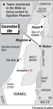
Deep in the ruins of a Hebrew town sacked nearly 3,000 years ago by an Egyptian Pharaoh, scientists say they have discovered new evidence for the real-life existence of the Bible's legendary kingdoms of David and Solomon.
The evidence refutes recent claims by other researchers who insist that the biblical monarchs were merely mythic characters, created by scholars and scribes of antiquity who made up the tales long after the events to buttress their own morality lessons.
The debate, however, is not likely to subside, for archaeology is a field notable for its lengthy quarrels among partisans, however scientific they may be.
The latest evidence comes from Israeli and Dutch archaeologists and physicists after seven years of digging at a historic site called Tel Rehov. The site is in the Jordan valley of Israel, where successive settlements rose and fell over the centuries.
Using highly sophisticated techniques for establishing dates through the decay rate of radioactive carbon, the scientists have pinned down the time of a disputed moment in history, recorded in the Bible, when a Pharaoh now known as Shoshenq I invaded Jerusalem.
As the book of Chronicles relates in the Old Testament, Shoshenq (the Bible called him Shishak) came "with twelve hundred chariots and threescore thousand horsemen" and plundered Israel's capital, as well as such towns and fortresses as Rehov, Megiddo and Hazor.
The Pharaoh later listed those conquests on a monument in the temple of Amun at Karnak, where the Egyptian city of Luxor now stands.
|
11=Gaza, Genesis 10:19, Joshua 10:41
12=Makkedah, Joshua 10:10 13=Rubuti, 14=Aijalon, Joshua 21:24 15=Kiriathaim?, 16=Beth- horon, Joshua 10:10 17=Gibeon, Joshua 9:3 18=Mahanaim, Genesis 32:2, Joshua13:26 19=Shaud[y], 20=?, 21=Adoraim, 2 Chronicles 11:9 22=Hapharaim, Joshua 19:9 23=Rehob, Numbers 13:21, Joshua 19:28 24=Betshan, 25= Shunem, Joshua 19:18 26=Taanach, Joshua 12:21 27=Megiddo, Joshua 12:21 28=Adar, Joshua 15:3 29=Yadhamelek, |
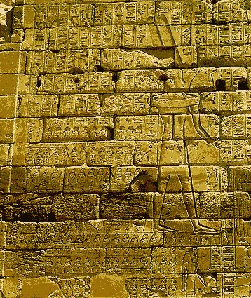
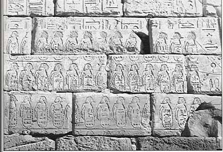
(List and second photo from http://www.specialtyinterests.net/sheshonk.html)
The new timetable places Shoshenq's rampage and looting at Rehov in the 10th century rather than the 9th, a highly significant difference. It sets the date at about 925 B.C., some five years after Solomon was said to have died, and some 80 years earlier than other archaeologists maintain.
Those scholars, known in the world of archaeology as "minimalists," insist that both David and Solomon were little more than tribal chieftains, and certainly not the mighty monarchs of the Bible.
A report on the new evidence appears today in the journal Science by Hendrik Bruins, a desert researcher at Ben-Gurion University of the Negev in Israel, Johannes van der Plicht of the Center for Isotope Research at the University of Groningen in the Netherlands, and Amihai Mazar of the Hebrew University of Jerusalem, the principal archaeologist at Tel Rehov.
In a telephone interview, Mazar said that one specific "layer of destruction" at the site yielded a harvest of charred grain seeds and olive pits that enabled his colleagues to date them with an unusually high level of precision. The dates of both earlier and later layers showed clearly how the successive layers of occupation could be determined from the 12th through the 9th centuries B.C., he said.
"They provide a precise archaeological anchor for the united monarchies of the time of David and Solomon," Mazar said. "The pottery we found there also tells us that the conquest dates from the same period as Meggido, when its mighty gates and walls and temples were also destroyed by Shoshenq's armies."
More than 40 years ago the late Yigael Yadin, who won fame as an army officer during Israel's war for independence, turned to archaeology and after excavating the imposing ruins at Megiddo maintained that they were in fact destroyed during the so-called Solomonic period.
Recently, however, a group of archaeologists led by Israel Finkelstein of Tel Aviv University working at Megiddo has insisted that the so-called Solomon's gate there dates from a much later time -- perhaps 100 or even 200 years after Solomon.
Finkelstein read a copy of the Mazar report that was sent him by e-mail. After replying that Mazar "is a fine scholar," he insisted that "there are many problems with his archaeological data" and that the samples of material used for the radiocarbon dating are at best questionable.
In the past, Finkelstein has accused Mazar of harboring a "sentimental, somewhat romantic approach to the archaeology of the Iron Age," according to an earlier account in Science.
On Thursday, however, one of the leaders in the archaeology of Israel, Professor Lawrence E. Stager, who is director of Harvard University's Semitic Museum, dismissed the claims of Finkelstein and the other archaeologists who share his views.
"Mazar and his colleagues have now put another nail in the coffin of Finkelstein's theories," Stager said. "There's no question that Rehov and the other cities that Shoshenq conquered were indeed there at the time of Solomon.
"We don't need to rely any more only on the Bible or on Shoshenq's inscriptions at Karnak to establish that Solomon and his kingdom really existed, because we now have the superb evidence of the radiocarbon dates."
copied from http://sfgate.com/cgi-bin/article.cgi?f=/c/a/2003/04/11/MN24970.DTL
|
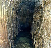
An ancient waterway, described in the Bible, has been located and radiocarbon-dated to around 700 BC1.
The half-kilometre Siloam Tunnel still carries water from the Gihon Spring into Jerusalem's ancient city of David. According to verses in Kings 2 and Chronicles 2 2, it was built during the reign of the King Hezekiah - between 727 BC and 698 BC - to protect the city's water supply against an imminent Assyrian siege. Critics argue that a stone inscription close to the exit dates the tunnel at around 2 BC.
To solve the conundrum, geologist Amos Frumkin, of the Hebrew University of Jerusalem, and colleagues looked at the decay of radioactive elements - such as carbon in plants and thorium in stalactites - in tunnel samples.
The plaster lining the tunnel was laid down around 700 BC, says Frumkin's team. A plant trapped inside the waterproof layer clocked in at 700-800 BC, whereas a stalactite formed around 400 BC. "The plant must have been growing before the tunnel was excavated; the stalactite grew after it was excavated," explains Frumkin.
The study "makes the tunnel's age certain", says archaeologist Henrik Bruins of Ben-Gurion University of the Negev, Israel. The Siloam Tunnel is now the best-dated Iron Age biblical structure so far identified.
The remains of buildings and structures described in the Bible are notoriously difficult to find. Specimens are rare, poorly preserved, hard to identify and often troublesome to access. Says James Jones, Bishop of Liverpool, UK: "This scientific verification of historical details in the Bible challenges those who do no wish to take it seriously."
Tunnel vision
The samples also help to explain how the tunnel was built. The passage is sealed with layers of plaster, the deepest and oldest of which is directly above the bedrock, with no sediment between. This shows that the plaster was applied immediately after the tunnel was built, Frumkin says.
"It's also quite unique to find well-preserved plant remains in plaster," says Bruins. Workers may have made up huge quantities outside the tunnel, where the plants could have become mixed in, and then taken it inside.
Large enough to walk inside, the Siloam Tunnel zigzags through an ancient hill. Its carved inscription describes how two teams of men, starting on opposite sides of the mountain, managed to meet in the middle. They may have followed a natural fissure in the limestone rock, Bruin suggests.
|
Unusually, the inscription does not name King Hezekiah - other monarchs commonly boasted of their architectural achievements in stone. The carving is six metres inside the tunnel, so it must have been made by lamplight.
"It wasn't meant to be seen by the public," says Biblical historian Andrew Millard of Liverpool University, UK. "I think it was the workmen recording what an extraordinary feat they had accomplished."
- Frumkin, A., Shimron, A. & Rosenbaum, J. Radiometric dating of the Siloam Tunnel, Jerusalem. Nature, 425, 169 - 171, (2003). |Article|
- 2 Kings 20:20; 2 Chronicles 32:3,4.
ˋ Nature News Service / Macmillan Magazines Ltd
2003
copied from http://www.nature.com/nsu/030908/030908-9.html

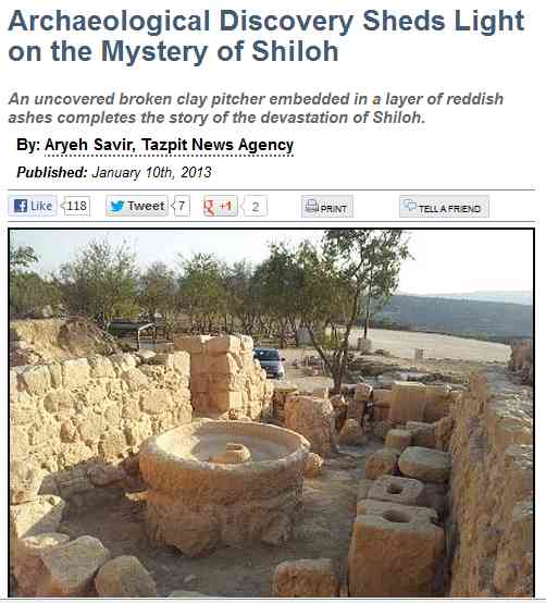
Tel Shiloh
(Photo Credit: Tazpit News Agency)
Recent archaeological findings in Samaria shed light on the incomplete story of the destruction of Shiloh, the ancient capital of Israel.
An uncovered broken clay pitcher embedded in a layer of reddish ashes completes the story of the devastation of Shiloh, where the Mishkan, the Tabernacle, was placed during the period of the Judges, and essentially served as Israels capital during the early part of the First Israelite commonwealth.
Shiloh served as the spiritual center of Israel for 369 years until its destruction. The Bible does not inform us of the story of its ruin, but these archaeological discoveries shed light on the capitals tragic demise.
The book of Samuel tells us of a battle between the Philistines and the Israelites, during which the Philistines prevailed, and during which the Holy Ark was captured by them. After hearing the news of the defeat from a messenger, Eli the High Priest, the leader of his time, who lost his two sons in the battle, fell back and died. This is all we learn of the defeat from the Book of Samuel.
We know that Shiloh was destroyed shortly thereafter. We know from the book of Jeremiah that Shiloh was destroyed by the Philistines. These new archaeological findings tell us of how it happened. After the battle, which took place at Even Haezel, near modern day Rosh Haayin, the Philistines moved on to destroy Shiloh, the capital. The ashes found attest to a devastating fire the occurred at the site. The dating of the clay pitcher, 1,050 BCE, correlates with the dating of the events depicted in Book of Samuel.
Avital Selah, director of the Tel Shiloh site, told Tazpit News Agency that these findings were discovered during a massive dig of the Tel Shiloh site, in which some 1000 youth volunteers from across Israel participated. Similar findings were discovered thirty years ago, including food leftovers, and their dating is also set at 1,050 BCE, but the recently discovered layer of ashes completes the story regarding the story of the destruction of the ancient Israelite capital of Shiloh.
from http://www.jewishpress.com/news/breaking-news/archaeological-discovery-sheds-light-on-the-mystery-of-shiloh/2013/01/10/?src=ataglance
Next let us go to the famous resort island of Maui !!
Our government, USGS , has done considerable research on the massive volcano on Maui.
They have climbed all over the volcano and obtained carbonized vegetation root samples for radiometric dating.
The following photo shows an example of how they do it.
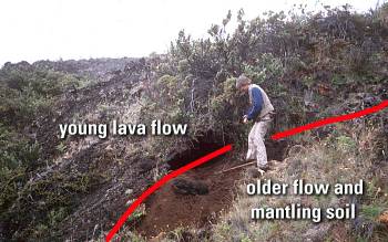
Digging into the soil buried by a lava flow they find charcoalized vegetation roots for radiocarbon dating. Charcoal from this hole site under and at the edge of a young flow yielded an age of 970Ý40 years.
This diagram shows where on the volcano they have obtained carbonized root samples.
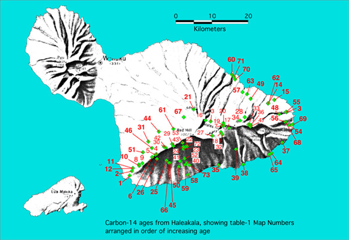
Here are the results.
1 390Ý50 SWR Younger La Perouse lava at Pu`u Kanaloa S99-HC678 this publication
2 460Ý50 SWR Younger La Perouse beneath spatter at Kalua o Lapa FAT-99-04d this publication
3 490Ý70 Hana Kawaipapa or "landfill" lava W4560 4
4 510Ý60 SWR Young fissure riven through Pu`u Makua FAT-96-29 2
5 590Ý120 SWR Young fissure riven through Pu`u Makua -- 8
6 650Ý140 SWR Fissure at Keonehunehune -- 8
7 870Ý40 HC Hanakauhi lava from a north-wall fissure S97-HC232c 9
8 600Ý300 SWR Probably Mahoe keiki lava; location unspecified -- 5
9 890Ý170 SWR Mahoe keiki lava -- 8
10 920Ý70 SWR Mahoe keiki lava W4297 4
11 910Ý40 SWR Mauka flow "1790" S99-HC688d this publication
12 950Ý40 SWR Mauka flow "1790" S99-HC688b this publication
13 940Ý50 HC Halali`i S97-HC137 9
14 960Ý50 Hana Pu`u Hina`i lava S00-HC1438 this publication
15 960Ý40 Hana Ka`eleku (Hana airport lava flow) S01-HC1731 this publication
16 970Ý50 HC Holua lava from Pu`u o ka `O`o S97-HC63c 9
17 1040Ý40 HC Kalua Awa lava S97-HC152 9
18 1160Ý50 HC Pu`u Nole lava S97-HC209 9
19 1870Ý40 HC Explosion crater S97-HC242 9
20 2340Ý40 HC Lava draping North crater wall vent on Kalapawili Ridge S01-HC1810B this publication
21 2530Ý50 HC Tephra collected on west flank; from within-crater vent W4554 4
22 3000Ý60 SWR Lava flow adjacent to east flank of Kahua cone FAT-96-11 2
23 3015Ý65 SWR Kamole Gulch lava downslope from Kahua cone BEM-176 2
24 3070Ý60 SWR Kamole Gulch lava adjacent to Kahua cone FAT-96-18 2
25 3090Ý30 SWR Auwahi lava (Giant tumulus lava) S01-HC1620B this publication
26 3540Ý40 SWR post-Makua lava collected near Pu`u `Ouli BEM-235b 2
27 3750Ý50 HC Tephra at foot of south crater wall S97-HC129 9
28 3850Ý50 ER Wai`ele`ele lava from cone east of Wai Anapanapa FAT-94-01 this publication
29 3890Ý40 SWR SWR ridgeline vent charcoal in roadcut S99-HC936 this publication
30 3900Ý60 SWR Kamaole eruption from vent at hairpin above Polipoli W4314 4
31 4070Ý90 SWR Kamaole lava downslope W4561 4
32 4070Ý50 HC Pu`u Maile S97-HC64c 9
33 4160Ý40 ER Silversword Gulch (informally named by NPS) S01-HC1784B this publication
34 4210Ý40 ER East Camp cinder cone S01-HC1792 this publication
35 4530Ý40 Kaupo Hawelewele Gulch 100-ft elevation S98-HC531 this publication
36 5020Ý40 ER Silversword Gulch (informally named by NPS) S01-HC1786 this publication
37 6710Ý40 Hana Muolea area highway roadcut S99-HC1067 this publication
38 7810Ý40 Kaupo Lava beneath Lo`alo`a 370 m NE of Kepio Pt S98-HC597c this publication
39 7980Ý40 Kaupo Lo`alo`a ankaramite 3080-ft S98-HC589 this publication
40 8160Ý40 SWR Kanahau ankaramite S00-HC1574 this publication
41 8180Ý40 SWR Kanahau lava ? S01-1627B this publication
42 8170Ý40 SWR SWR ridgeline vent beneath spatter in gully exposure S99-HC925 this publication
43 8190Ý60 SWR Upper flank aphyric lava FAT-96-23 2
44 8650Ý90 SWR Waiohuli lava W4557 4
45 8710Ý40 SWR Lava from vent west of Kanahau S01-HC1604 this publication
46 8830Ý50 SWR North of Ulupalakua unit hpae of Bergmanis BEM-215 2
47 9400Ý300 ER Cinder cone near head of Kipahulu Valley W3945 4
48 9500Ý40 Hana From upper Kawaipapa Gulch S99-HC1123 this publication
49 9520Ý70 Nahiku Kuhiwa basanite S00-HC1414B this publication
50 10120Ý40 SWR Aphyric lava that inundated Manukani S01-HC1594 this publication
51 10290Ý50 SWR NW flank flow unit hkea of Bergmanis BEM-214 2
52 10440Ý60 SWR Upper south flank east of Kahua cone FAT-96-14 2
53 10470Ý50 SWR Small fissure eruption upslope of Kahua cone S99-HC803 this publication
54 12760Ý120 Hana Haneo`o ankaramite W4754 4
55 12760Ý50 Hana Lower Kawaipapa Gulch S bank of plunge pool S99-HC1078 this publication
56 13450Ý50 Hana Mo`omo`onui Gulch upsection from HC1106 S99-HC1105B this publication
57 16720Ý110 Nahiku Pa`akea lava roadcut at Three Bridges S00-HC1339 this publication
58 17010Ý50 SWR Nawini ankaramite S00-HC1532AB this publication
59 17230Ý50 SWR Nawini ankaramite S00-HC1579 this publication
60 17860Ý60 Keanae Pi`ina`au lava Keanae S01-HC1668B this publication
61 22550Ý400 SWR West-flank tephra Waipoli Road W4004 4
62 22770Ý220 Hana Paki lava S00-HC1436B this publication
63 23530Ý200 Nahiku Nahiku (Mossman) ankaramite S00-HC1401 this publication
64 23820Ý90 Kipahulu Palikea ankaramite in low seacliff SW of Kuloa Pt S99-HC962A this publication
65 24170Ý80 Kipahulu Kekue Bay S99-HC1119 this publication
66 25790Ý100 SWR Nini`ali`i lava west of Luala`ilua Hills S01-HC1760 this publication
67 26800Ý400 SWR West-flank tephra Waipoli Road W4315 4
68 34100Ý290 Hana Mo`omo`onui Gulch 500 ft downsection from HC1105 S99-HC1106B this publication
69 37150Ý410 Hana Pu`u Kolo(?) lava at Ka Iwi o Pele S99-HC1127 this publication
70 39920Ý400 Ke`anae `Ohi`a lava S01-HC1729C this publication
71 43800Ý1400 Keanae Pi`ina`au lava (caps conglomerate) Keanae S98-HC310 9
72 45000Ý1800 SWR Upper south flank east of Kahua cone FAT-96-13 2
73 52900Ý1800 SWR Kahua lava; source vent uncertain S00-HC1524A this publication
1 390Ý50 SWR Younger La Perouse lava at Pu`u Kanaloa S99-HC678 this publication 2 460Ý50 SWR Younger La Perouse beneath spatter at Kalua o Lapa FAT-99-04d this publication 3 490Ý70 Hana Kawaipapa or "landfill" lava W4560 4 4 510Ý60 SWR Young fissure riven through Pu`u Makua FAT-96-29 2 5 590Ý120 SWR Young fissure riven through Pu`u Makua -- 8 6 650Ý140 SWR Fissure at Keonehunehune -- 8 7 870Ý40 HC Hanakauhi lava from a north-wall fissure S97-HC232c 9 8 600Ý300 SWR Probably Mahoe keiki lava; location unspecified -- 5 9 890Ý170 SWR Mahoe keiki lava -- 8 10 920Ý70 SWR Mahoe keiki lava W4297 4 11 910Ý40 SWR Mauka flow "1790" S99-HC688d this publication 12 950Ý40 SWR Mauka flow "1790" S99-HC688b this publication 13 940Ý50 HC Halali`i S97-HC137 9 14 960Ý50 Hana Pu`u Hina`i lava S00-HC1438 this publication 15 960Ý40 Hana Ka`eleku (Hana airport lava flow) S01-HC1731 this publication 16 970Ý50 HC Holua lava from Pu`u o ka `O`o S97-HC63c 9 17 1040Ý40 HC Kalua Awa lava S97-HC152 9 18 1160Ý50 HC Pu`u Nole lava S97-HC209 9 19 1870Ý40 HC Explosion crater S97-HC242 9 20 2340Ý40 HC Lava draping North crater wall vent on Kalapawili Ridge S01-HC1810B this publication 21 2530Ý50 HC Tephra collected on west flank; from within-crater vent W4554 4 22 3000Ý60 SWR Lava flow adjacent to east flank of Kahua cone FAT-96-11 2 23 3015Ý65 SWR Kamole Gulch lava downslope from Kahua cone BEM-176 2 24 3070Ý60 SWR Kamole Gulch lava adjacent to Kahua cone FAT-96-18 2 25 3090Ý30 SWR Auwahi lava (Giant tumulus lava) S01-HC1620B this publication 26 3540Ý40 SWR post-Makua lava collected near Pu`u `Ouli BEM-235b 2 27 3750Ý50 HC Tephra at foot of south crater wall S97-HC129 9 28 3850Ý50 ER Wai`ele`ele lava from cone east of Wai Anapanapa FAT-94-01 this publication 29 3890Ý40 SWR SWR ridgeline vent charcoal in roadcut S99-HC936 this publication 30 3900Ý60 SWR Kamaole eruption from vent at hairpin above Polipoli W4314 4 31 4070Ý90 SWR Kamaole lava downslope W4561 4 32 4070Ý50 HC Pu`u Maile S97-HC64c 9 33 4160Ý40 ER Silversword Gulch (informally named by NPS) S01-HC1784B this publication 34 4210Ý40 ER East Camp cinder cone S01-HC1792 this publication 35 4530Ý40 Kaupo Hawelewele Gulch 100-ft elevation S98-HC531 this publication 36 5020Ý40 ER Silversword Gulch (informally named by NPS) S01-HC1786 this publication 37 6710Ý40 Hana Muolea area highway roadcut S99-HC1067 this publication 38 7810Ý40 Kaupo Lava beneath Lo`alo`a 370 m NE of Kepio Pt S98-HC597c this publication 39 7980Ý40 Kaupo Lo`alo`a ankaramite 3080-ft S98-HC589 this publication 40 8160Ý40 SWR Kanahau ankaramite S00-HC1574 this publication 41 8180Ý40 SWR Kanahau lava ? S01-1627B this publication 42 8170Ý40 SWR SWR ridgeline vent beneath spatter in gully exposure S99-HC925 this publication 43 8190Ý60 SWR Upper flank aphyric lava FAT-96-23 2 44 8650Ý90 SWR Waiohuli lava W4557 4 45 8710Ý40 SWR Lava from vent west of Kanahau S01-HC1604 this publication 46 8830Ý50 SWR North of Ulupalakua unit hpae of Bergmanis BEM-215 2 47 9400Ý300 ER Cinder cone near head of Kipahulu Valley W3945 4 48 9500Ý40 Hana From upper Kawaipapa Gulch S99-HC1123 this publication 49 9520Ý70 Nahiku Kuhiwa basanite S00-HC1414B this publication 50 10120Ý40 SWR Aphyric lava that inundated Manukani S01-HC1594 this publication 51 10290Ý50 SWR NW flank flow unit hkea of Bergmanis BEM-214 2 52 10440Ý60 SWR Upper south flank east of Kahua cone FAT-96-14 2 53 10470Ý50 SWR Small fissure eruption upslope of Kahua cone S99-HC803 this publication 54 12760Ý120 Hana Haneo`o ankaramite W4754 4 55 12760Ý50 Hana Lower Kawaipapa Gulch S bank of plunge pool S99-HC1078 this publication 56 13450Ý50 Hana Mo`omo`onui Gulch upsection from HC1106 S99-HC1105B this publication 57 16720Ý110 Nahiku Pa`akea lava roadcut at Three Bridges S00-HC1339 this publication 58 17010Ý50 SWR Nawini ankaramite S00-HC1532AB this publication 59 17230Ý50 SWR Nawini ankaramite S00-HC1579 this publication 60 17860Ý60 Keanae Pi`ina`au lava Keanae S01-HC1668B this publication 61 22550Ý400 SWR West-flank tephra Waipoli Road W4004 4 62 22770Ý220 Hana Paki lava S00-HC1436B this publication 63 23530Ý200 Nahiku Nahiku (Mossman) ankaramite S00-HC1401 this publication 64 23820Ý90 Kipahulu Palikea ankaramite in low seacliff SW of Kuloa Pt S99-HC962A this publication 65 24170Ý80 Kipahulu Kekue Bay S99-HC1119 this publication 66 25790Ý100 SWR Nini`ali`i lava west of Luala`ilua Hills S01-HC1760 this publication 67 26800Ý400 SWR West-flank tephra Waipoli Road W4315 4 68 34100Ý290 Hana Mo`omo`onui Gulch 500 ft downsection from HC1105 S99-HC1106B this publication 69 37150Ý410 Hana Pu`u Kolo(?) lava at Ka Iwi o Pele S99-HC1127 this publication 70 39920Ý400 Ke`anae `Ohi`a lava S01-HC1729C this publication 71 43800Ý1400 Keanae Pi`ina`au lava (caps conglomerate) Keanae S98-HC310 9 72 45000Ý1800 SWR Upper south flank east of Kahua cone FAT-96-13 2 73 52900Ý1800 SWR Kahua lava; source vent uncertain S00-HC1524A this publication
So what does this mean to us ??
Scanning down the results starting at 390 years ago you will see a smooth progression to the end with the top value.
This smooth progression indicates that there has been no massive flood here to cause the data to become invalid!
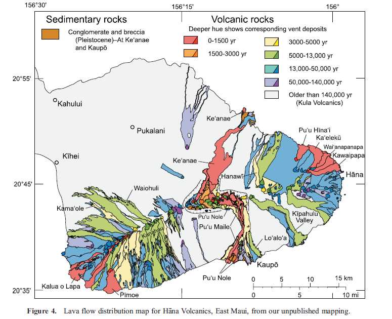
Here is how the flows on the volcano are mapped.
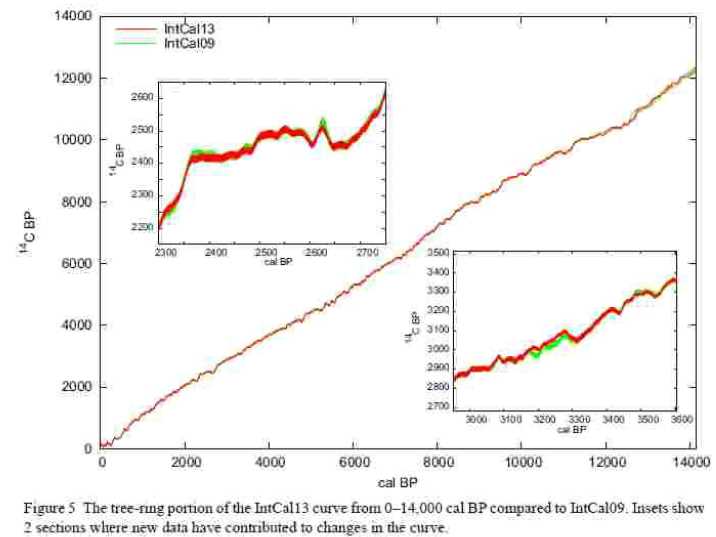
And of course the scientists who work with 14C dating calibration standards also see no
sudden changes at the time of the Flood from the tree ring data.
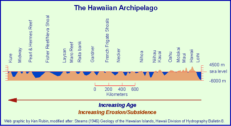
Here is a diagram showing the amazing Hawaiian Archipelago and how the latest formed volcanoes to the right have peaks
above sea level and as you proceed to the left the peaks have been worn down to sea level and below by the action of the sea indicating the
great age of these volcanoes!
Also we take a look at some of the 14C data from Hawaii, we see no sudden changes in the data at the proposed time of the Flood.
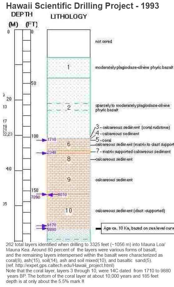
First data from the 1993 "Hawaii Scientific Drilling Project" at 102 to 185 feet where there was a 83 feet thick coral deposit which 14C dated as follows.

If the coral growth rate was linear we might expect the values at 152-153 ft to be closer to 6600 years, but there was enough pattern differences for them to assign the coral to 8 different layers. See figure below.
Conclusion:The problems that young earth creationists have with 14C dating are unfounded and their proposed major change of 14C levels due to a "global flood" are just not present !!