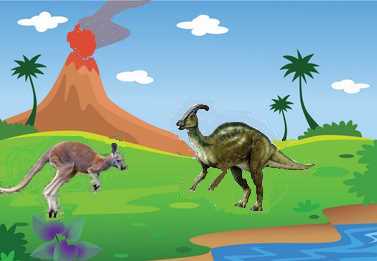
Hadrosaurs...Volcanoes
Marsupials...Genesis
REPRINT FROM
DINOSAUR TRACKS AND TRACES
Edited by DAVID D. GILLETTE AND MARTIN G. LOCKLEY
Cambridge University Press, 1989
DINOSAUR FOOTPRINTS FROM A COAL MINE IN EAST-CENTRAL UTAH
LEE R. PARKER AND ROBERT L. ROWLEY, JR.
Abstract
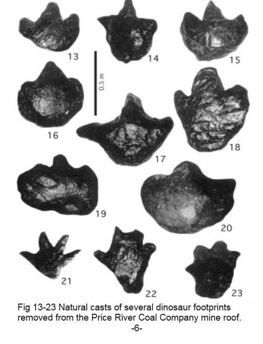
Thousands of natural casts of dinosaur footprints occur in the roof surface of a mine in an Upper Cretaceous coal in east-central Utah. Ninety three have been removed for study. They range in length from 28 to 87.5 cm. Most are three-toed forms; only two types are four-toed. About 14 dinosaur taxa were probably responsible for producing the specimens in the collection. These tracks were made by animals which walked in the peat on the surface of a swamp; their footprints were filled by mud, silt or sand during the flooding of a local river. Most footprints are very broad with short thick toes, apparently well-adapted for walking on soft peat. Some footprint casts become loose in the mine roof and can fall, creating a hazardous condition for miners, especially in the case of tracks weighing up to 140 kg. In order to collect quality tracks, they must be chiseled from the roof rock matrix. Footprints from coal mines are well-known in central Utah and are displayed in front of the homes of miners and also in some businesses.
Introduction
For twelve years one of us (Rowley) has been able to examine thousands of natural casts of dinosaur footprints as they occur in the roof surface of the Price River Coal Company mine in Spring Canyon, west of Helper, Utah. Ninety three have been removed for further study. This report briefly describes the conditions involved in the formation and collection of these dinosaur footprint casts and illustrates 14 types which have been collected.
Dinosaur footprints occur in the mine roof surfaces as protrusions which hang down from the roof, sometimes as far as 30 cm. They often occur in trackways made by bipedal animals or are positioned around tree bases; some times the tracks are over the top of woody litter or tree roots, indicating that the animals had been walking on that material as it occurred on the swamp forest floor. Frequently, the roof surface is so covered with them that one track oversteps another, similar to tracks of livestock in a corral (Peterson 1924, Parker and Balsley 1989 and in prep.). Because of overstepping or incomplete depression of the foot into the peat, few tracks are of the "exhibit" quality which is desirable for removal. The sediment which filled in the original footprints is usually a light-colored fluvial shale or siltstone. The lower surfaces of most tracks are partially or completely covered with a thin layer of hard vitreous coal or a fine-grained carbonaceous siltstone, both of which have a highly polished slickenside-like surface.
The occurrence of natural casts of dinosaur foot prints from coal mines is well-known locally. It is common to see them displayed as a front yard ornament at miners' homes or as conversation pieces in reception areas of some businesses in the cities of Helper and Price. Since they can be as long as 1 m and weigh hundreds of kilograms, they are an impressive natural curiosity.
The College of Eastern Utah Prehistoric Museum in Price has a good display of several track types. It also contains a part of the W. D. Wilson collection of many types and sizes (Lockley 1986). A collection of 30 tracks, described by Strevell (1932), is housed at the Utah State Natural History Museum, University of Utah, in Salt Lake City (Frank L. De Courten pers. comm. 1986). However, the largest collection of fossil footprint casts from coal mines of the Rocky Mountain area in terms of variety and total specimen numbers is the one illustrated in this report (made by Rowley). It numbers nearly 100 specimens, and includes 14 different footprint morphotypes. Other museums which we know to have one or several specimens include: The American Museum of Natural History, New York; California Polytechnic State University, San Luis Obispo; The Field Institute of Natural History, Chicago, Illinois; Louisiana Polytechnic Institute, Ruston; New Mexico Museum of Natural History, Albuquerque; Peabody Museum of Natural History, New Haven, Connecticut; The Museum of Western Colorado, Grand Junction; San Diego Museum of Natural History, San Diego, California; The Smithsonian Institution, Washington, D.C.; The South Dakota School of Mines and Technology, Rapid City; University of Pennsylvania, Philadelphia (Strevell 1932); University of New Mexico, Albuquerque (Ratkevich 1976) and Utah State University, Logan (Peterson 1924).
Geologic Setting and Paleoecology
The Castlegate D Seam which the Price River Coal Company is mining is one of several coals in the Upper Cretaceous (Campanian) Blackhawk Formation (Doelling 1972). It was developed from a peat-forming swamp on the upper surface of the sheet-like sands of the Aberdeen Member. This member represents one of several major deltas in the formation which prograded into the Cretaceous epicontinental seaway and allowed the development of brackish and freshwater swampy environments when subaerial surfaces occurred (Balsley and Parker 1983).
Animals living on the swamp surface made deep footprints into the peat. Before they became obliterated by the rebounding peat, a local river flooded and deposited overbank sediment into the swamp, filling the footprints and thus preserving them. Later, the peat became coal and has been removed, allowing an examination of the natural casts of these footprints and other fossils which were on the swamp surface (Parker and Balsley 1989 and in prep.). Like many other Blackhawk mine roof surfaces, there are abundant fossil leaves, horizontal logs and trees in growth position which are directly associated with dinosaur footprint casts (Parker and Balsley in prep.). Recently, Rowley has collected several ferns, dicot leaves, petrified tree stumps, pelecypods and gastropods from the roof of the Price River mine, all of which made up a portion of the swamp flora and fauna at the time the footprints were made.
Removal of Tracks from the Roof Surface
As the coal is being mined it normally separates easily from the roof rock, exposing sedimentary features and fossils which might be present. Footprints can be removed where the roof rock is carbonaceous shale or siltstone; sometimes these specimens are loose and are easily pried down. The best tracks for removal are those which extend down from the roof surface at least 10 cm and have a carbonaceous layer above them. Because they are heavy and positioned slightly above head height, it is impossible for one or two persons to safely hold or catch them when they separate from the roof. Therefore, it is necessary to prepare a cushion under them and allow them to fall on it. Mine "brattice", a yellow plastic-impregnated fabric used in mines as a fire retardant and as a drape for directing ventilating air, has been effectively used for this purpose. The sedimentary matrix around the track is chiselled away with hand tools until a groove or channel is formed around it. Eventually, horizontal chiseling, up behind the track, will loosen it and allow it to drop from the roof. Specimens as large as 140 kg have been obtained in this manner without damage to the tracks. An average weight of the tracks after removal is about 45 kg. Outside the mine, extraneous coal and rock matrix can be cleaned away. Sandstone preserves footprints less frequently, but, because it makes a much harder surrounding matrix, sandstone tracks have been impossible to remove intact.
Dinosaur Tracks and Mine Safety
During the removal process it is important to consider the structural integrity of the surrounding roof to insure that large blocks of rocks do not fall. In addition, the presence of "black damp" (a deficiency of oxygen, including the build-up of carbon dioxide and carbon monoxide) and methane must continually be checked, since these gases can accumulate very quickly at certain times in a working mine.
Dinosaur footprint casts which extend down from the roof several inches are a nuisance where the coal seam
is thin, causing the roof to be low; mine workers continually bump their heads on them. More serious problems
have existed with them since mining began in the area in the early part of the century, because they fall and kill
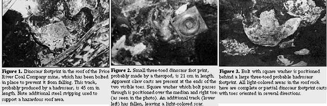
or seriously injure mine workers. Therefore, loose footprints are bolted to the roof with a vertical drill designed
to drive a 1 to 3 m long steel bolt upward into the roof rock and prevent tracks and blocks of rock from falling
(Figs. 1-3). We are unaware of other lethal trace fossils, nor do we know of other circumstances where dinosaur
activity has contributed to the possible death of human beings.
Morphology of the Footprints
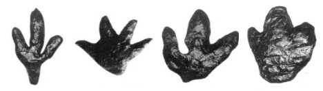
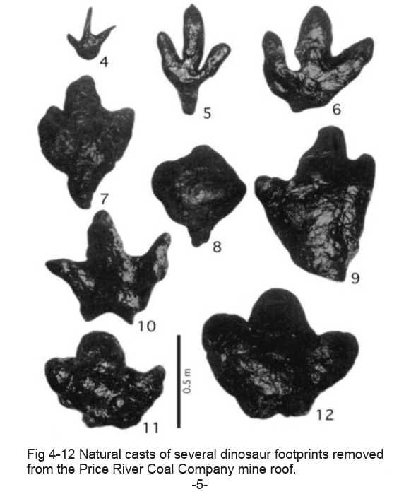
The natural footprint casts collected from the Price River Mine seem to have been produced by several animal taxa. A few of the casts we illustrate here (Figs. 9-23) have similar morphologies, suggesting that they may have been made by the same dinosaur species, depending on age of the animal or activities at the time the footprints were made. However, it should be emphasized that all those 14 morphotypes illustrated are represented in the collection by at least four similar specimens. The only exception is the specimen shown as Figure 22, which is unique in the collection. Certain track types are represented by as many as 12 specimens including distinct left and right pes. In addition, it is clear from examinations of primary sedimentary features in the roof surface that all footprints had been pressed into peat; none were made in clastic sediment. Therefore, the morphological consistency of all specimens of each track type, each produced on the same kind of surface, suggests that the dinosaur fauna included at least 14 taxa. Most Price River specimens are three-toed; only two types are fourtoed. No five-toed tracks have been observed in this mine, but they are known in other Blackhawk Formation coal mines. These tracks range in length from 28 to 87.5 cm. With a few exceptions, the foot prints, which are mostly pedes, have short toes on wide, apparently flat feet (Figs. 1, 3, 7-20, 23). This broad foot structure seems to have been adapted for walking on the soft peat of the swamp surface, similar to a snowshoe. Tracks with narrow toes occur but they are rare, both in the collection and in the actual mine roof (Figs. 2, 4-6, 21). Lull (Strevell 1932) gave Latin binomials to eight ichnospecies of the ichnogenus "Dinosauropodes" collected from a coal in the now-abandoned Standard mine (Blackhawk Formation, Castlegate A and B Coals, Doelling 1972), although Lockley and Jennings (1987) indicated that these names are not valid. Three of the species collected in the Price River mine are similar in size and shape to those in the Standard mine: D. bransfordii (Fig. 7); D. magrawii (although our specimens are not as large; Fig. 9); and D. osborni (Fig. 23). In addition, at least six species from the Price River mine have been seen in a Kenilworth mine (Blackhawk Formation, Kenilworth Coal, Parker and Balsley in prep.). These have not been described nor given Latin binomials, but include those shown here as Figures 1, 4, 7, 10, 16, and 18.
The fact that certain of these track types occur in three stratigraphically different coals in the Blackhawk Formation indicates that the animals which produced them were part of the Cretaceous swamp fauna for a great length of time. Other types, collected in only one coal bed, may be restricted in time and may prove useful as stratigraphic or paleoecologic indicators.
Diagnostic skeletal material is rarely collected in the Blackhawk Formation. What has been collected includes a carnosaur tooth (Steven F. Robison pers. comm. 1984) and the skull of Albertosaurus sp. (James H. Madsen, Jr., pers. comm. 1985; Parker and Balsley in prep.). It is thought that many of the large, flat footprint types were made by unidentified hadrosaurian species (Figs. 1, 3, 7-9, 11-20) (Strevell 1932, Parker and Balsley in prep.), certain of the narrow-toed forms were probably made by theropods like Albertosaurus (Figs. 2, 4-6, 10, 21), and a ceratopsian probably produced the four-toed specimen (Fig. 23, cf. Lockley 1986, Lockley and Jennings 1987).
____________________
References
Balsley, J. K., and Parker, L. R. 1983. Cretaceous Wave-dominated Delta, Barrier Island, and Submarine Fan
Depositional Systems: Book Cliffs east central Utah. Arner. Assoc. Petrol. Geol. Field Guide. 279 pp.
Doelling, H. H. 1972. Central Utah Coal Fields: Sevier-Sanpete, Wasatch Plateau, Book Cliffs and Emery. Utah
Geol. Min. Surv. Monog. No. 3. 496 pp.
Lockley, M. G. 1986. Dinosaur Tracksites. Univ. Colorado Denver Geol. Dept. Mag. Spec Issue No. 1. 56 pp.
Lockley, M. G., and Jennings, C. 1987. Dinosaur tracksites of western Colorado and eastern Utah. In Averett, W.
R. (ed.). Paleontology and Geology of the Dinosaur Triangle. (Grand Junction, Colorado: Museum of Western
Colorado Press) 162 pp.
Parker, L. R., and Balsley, J. K. 1988. Coal Mines as Localities for Studying Dinosaur Trace Fossils. In D.D. Gillette
and M.G. Lockley (ed.) Dinosaur Tracks and Traces (Cambridge University Press) 353 pp. in prep: Plant fossils and
dinosaur footprints in coal mine roof surfaces.
Peterson, W. 1924. Dinosaur tracks in the roofs of coal mines. Nat. Hist. 24 (3):388-391.
Ratkevich, R. P. 1976. Dinosaurs of the Southwest. (Albuquerque: University of New Mexico Press) 115 pp.
Strevell, C. N. 1932. Dinosauropodes. (Salt Lake City: C. N. Strevell and Deseret News Press) 15 pp.
SCIENCE NEWS ... July 31, 2007 Rare fossilized cypress trees found in Hungary BUDAPEST (Reuters) - Hungarian scientists said on Tuesday they have discovered a group of fossilized swamp cypress trees preserved from 8 million years ago which could provide clues about the climate of pre-historic times.
Instead of petrifying -- turning to stone -- the wood of 16 Taxodium trees was preserved in an open-cast coal mine allowing geologists to study samples as if they were sections cut from a piece of living wood.
"The importance of the findings is that so many trees got preserved in their original position in one place," Alfred Dulai, geologist at the Hungarian Natural History Museum said.
The trees, which stand 4-6 meters tall and 1.5-3 meters in diameter, were found when miners started to remove a deep layer of sand at a mine in the north-eastern village of Bukkabrany to get at deposits of lignite. The trees date back to the late Miocene geological period at a time when the Carpathian basin -- present day Hungary -- was a freshwater lake surrounded by swamps.
The trees were found on top of the lignite, capturing one of the last moments of these swamps, ...
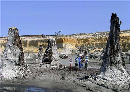
Science Image: Hungarian scientists look at a group of fossilized swamp cypress trees or Taxodium trees preserved in an open-cast lignite mine in the northeast of Hungary in this picture taken July 16, 2007. The trunks of the trees were preserved in a remarkable condition, standing at 4-6 metres tall and 1.5-3 metres in diameter just as they were in the late Miocene geological period 8 million years ago. Picture taken July 16, 2007. REUTERS/Otto Herman Museum
"At the beginning of the Flood thousands of volcanoes mowed down forests all over the world. Volcanic ash fell on top of huge floating log mats. When those log mats were buried in-between the heated sedimentary layers deposited by the Flood, coal and oil were formed in a short amount of time." WRONG!!
It is only in the imagination of some men that volcanism was a part of the flood!!
In the King James Bible the waters (H4325) are mentioned 21 times from Genesis 6:17 to 9:15 and rain (H4305 & H1653) three times. The flood/deluge (H3999) is mentioned 12 times from Genesis 6:17 to 11:10. None of these four Hebrew words have any connection with volcanism!! The only Hebrew word with a possible connection to volcanism is H5467 ńŔăÉí sed.m sed-ome' , per Strong.
Gen 7:11 ... the fountainsH4599 of the greatH7227 deepH8415 broken up,H1234 ...
Neither Strong or Brown-Driver-Briggs mention volcanism in H4599, H8415, and H1234 !
H4599 mah-yawn', mah-yen-o', mah-yaw-naw'
From H5869 (as a denominative in the sense of a spring); a fountain (also collectively), figuratively a source (of satisfaction): - fountain, spring, well.
Total KJV occurrences: 23 [fountain/s (16x) well/s(5x) springs(2x)
Gen 7:10 And it came to passH1961 after sevenH7651 days,H3117 that the watersH4325 of the floodH3999 wereH1961 uponH5921 the earth.H776 (land)
Isa 12:3 Therefore with joyH8342 shall ye drawH7579 waterH4325 out of the wellsH4480 H4599 of salvation/victory/health.H3444
Isa 41:18 I will openH6605 riversH5104 inH5921 high places,H8205 and fountainsH4599 in the midstH8432 of the valleys:H1237 I will makeH7760 the wildernessH4057 a poolH98 of water,H4325 and the dryH6723 landH776, springsH4161 of water.H4325
Fountains/wells/springs of water as a blessing (13x), unless dried up (7x) and in a deluge (3x), never as volcanism !
H8415 teh-home', teh-home'
(Usually feminine) from H1949; an abyss (as a surging mass of water), especially the deep (the main sea or the subterranean water supply): - deep (place), depth.
Total KJV occurrences: 36 [deep/s(21x) depth/s(15x)]
H1234 baw-kah'
A primitive root; to cleave; generally to rend, break, rip or open: - make a breach, break forth (into, out, in pieces, through, up), be ready to burst, cleave (asunder), cut out, divide, hatch, rend (asunder), rip up, tear, win. [to cleave: To part or divide by force; Webster]
Total KJV occurrences: 51 [cleave (10x), ...up (9x), divide (5x), rent (4x), (misc 23x)]
Nowhere in the Bible does it say that volcanism was a part of the flood!!
Volcanoes in Hawaii provide evidences that a recent global flood did NOT happen ! Young earth theories require large magnitudes of change to the earth surface and the atmosphere resulting in disturbances to the 14C content. However, data published by the USGS as they studied the top surface of the volcano on the island of Maui indicates no significant changes! They located visable edges of lava flows and dug into the soil buried by the lava flow to obtain charcoalized roots for radiocarbon dating at more than 73 locations and mapped the flows as shown below. (Kilauea in upper left corner for 1000 years.)
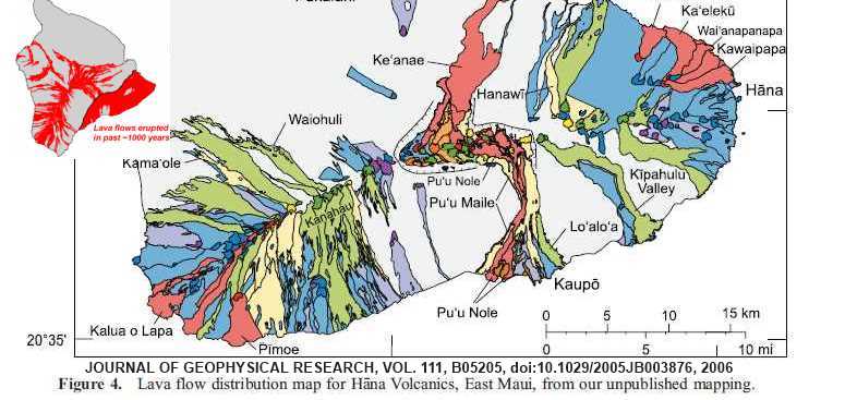
With the proposed flood at 2348 BC by young earth theory there should be some sort of change at that time, but the data is smooth from 4070 to 10,120 years BP, within the physical constraints of the surface and data as follows. (Lava flows are sporadic and widely distributed as shown by recent flows on Kilauea.)
32 4070±50 HC Pu`u Maile S97-HC64c 9
33 4160±40 ER Silversword Gulch (informally named by NPS) S01-HC1784B this publication
34 4210±40 ER East Camp cinder cone S01-HC1792 this publication
35 4530±40 Kaupo Hawelewele Gulch 100-ft elevation S98-HC531 this publication
36 5020±40 ER Silversword Gulch (informally named by NPS) S01-HC1786 this publication
37 6710±40 Hana Muolea area highway roadcut S99-HC1067 this publication
38 7810±40 Kaupo Lava beneath Lo`alo`a 370 m NE of Kepio Pt S98-HC597c this publication
39 7980±40 Kaupo Lo`alo`a ankaramite 3080-ft S98-HC589 this publication
40 8160±40 SWR Kanahau ankaramite S00-HC1574 this publication ...
44 8650±90 SWR Waiohuli lava W4557 4
45 8710±40 SWR Lava from vent west of Kanahau S01-HC1604 this publication
46 8830±50 SWR North of Ulupalakua unit hpae of Bergmanis BEM-215 2
47 9400±300 ER Cinder cone near head of Kipahulu Valley W3945 4
48 9500±40 Hana From upper Kawaipapa Gulch S99-HC1123 this publication ...
50 10120±40 SWR Aphyric lava that inundated Manukani S01-HC1594 this publication
No evidence of a world wide flood during this time span!!
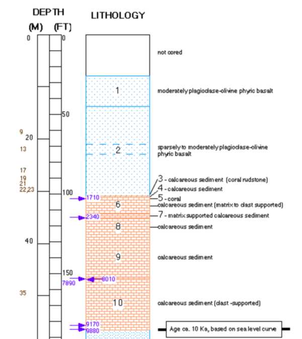
Also the 1993 "Hawaii Scientific Drilling Project" drilled through 8 layers of coral and showed no significant change in the coral reef formation process from 1710 to 9880. The coral layers, 3 thru 10, were 14C dated from 1710 BP to 9880 BP as identified by the arrows. Averaging 3.2 meters of coral reef growth per 1000 years which is consistent with recent studies in the Gulf of Panama showing a average growth rate of 1.3 to 4.2 m/kyr. There was no indication of any major change to the environment during this time span when a theorized "global flood" would have taken place !! The technology for 14C dating has been confirmed by studies in Israel at Biblical locations including the Siloam Tunnel at 700 BC, Rehov at 925 BC, and Shiloh at 1050 BC.
They drilled 3325 feet (~1056 m) into Mauna Loa/Maunia Kea.
The depth shown is only about 5% of the total drilling depth.
These volcanoes tower about 9200 meters above the ocean floor!
Identified were 262 distinct layers, 80% basalt, 6 layers coral,
15 of ash, 14 of soil, 5 of sand, and 10 layers ash and soil mixed.
( ref: //expet.gps.caltech.edu/Hawaii_project.html)
Salt deposits
"Although all water bodies on the surface and in aquifers contain dissolved salts, the water must evaporate into
the atmosphere for the minerals to precipitate. For this to happen, the water body must enter a restricted
environment where water input into this environment remains below the net rate of evaporation. This is usually
an arid environment with a small basin fed by a limited input of water. When evaporation occurs, the
remaining water is enriched in salts, and they precipitate when the water becomes supersaturated." (from
Evaporite - Wikipedia.htm) Evaporation of about 80 feet of sea water is required to produce a foot of salt. Salt
deposits found in Kansas are as shown below.

"The Hutchinson Salt Member covers about 37,000 square miles in the subsurface of central and south-central Kansas, reaching a maximum thickness of more than 500 feet under Clark, Comanche, and Barber counties. As shown thick salt layers also occur in western and southwestern Kansas in the Ninnescah Shale and Blaine Formation/Flower-pot Shale. The eastern edge of the Hutchinson Salt Member is actively being eroded, or dissolved, by contact with ground water. This area, where the salt is closest to the surface, is known as the dissolution front. Because salt is so easily dissolved in water, outcrops at the surface are not present.
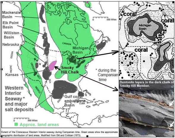
Major salt deposits occurred in various geologic eras and all of them are the remains of ancient inland seas. The large Michigan salt basin formed at an early time and in a tropic or sub-tropic environment since it is bounded by large coral reefs requiring shallow water with water temperatures consistently above 77 degrees F. As the land rose the shorelines of these ancient seas moved and the outline of the edges during various eras mark the occurrences of the oil, gas and coal deposits which have been found in abundance. The about 600 feet thick formation of the Smoky Hill Chalk member in southeastern Nebraska and northwest Kansas also were deposited near the center of the Western Interior Sea. This chalk deposit have more than a hundred thin layers of bentonite clay, most of which are rusty red in color, that are the result of the fall of ash from repeated eruptions of volcanoes to the west of Kansas in what is now Nevada and Utah.
The Western Interior Seaway was a warm and tropical shallow sea, at its deepest 2,600 or 3,000 ft deep, and was filled with abundant marine life. Interior Seaway denizens included predatory marine reptiles such as plesiosaurs, and mosasaurs that grew up to 18 metres (59 ft) long. Thousands of mosasaur specimens have been collected from the Smoky Hill Chalk Member. In a mountain-building episode called the Laramide orogeny, the Western Interior Seaway divided across the Dakotas and retreated south towards the Gulf of Mexico. This shrunken, regressive phase of the Western Interior Seaway is sometimes called the Pierre Seaway. After it was gone giant mammoths roamed the area. Mammoth fossils have been found in all 93 of Nebraska's counties, and it is estimated that the remains of ten mammoths lie buried in an average square mile of Nebraska landscape! The best mammoth remains are usually found in the western part of the state, frequently near major rivers.

The very presence of bedded salt in the geologic record is evidence that it was not deposited during a WET "global flood" year (371 days). Salt dissolves in water, it doesn’t deposit out of water unless the water is saturated with salt. And when it is saturated with salt, no vertebrate life can live in those waters. So, why do we find huge salt beds in the middle of the sedimentary rock formations, which are very widespread and in some locations stacked one above another as shown above? How did this happen in the midst of the Noachian flood? Obviously it didn't !!
Permafrost/Missing Isotopes/Impact Craters
In a Bishop Ussher/Henry Morris world with the flood at 2348 BC it leaves less than 4330 years after the flood for the permafrost under Prudhoe Bay, Alaska to form to depth, 687.7 meters (circa 1982) and in Siberia to 1493 m (4898 ft) as in the northern Lena and Yana River basins in Siberia !!
Due to a vapor canopy; " (6) The combination of warm temperature and adequate moisture everywhere would be conducive later to extensive stands of lush vegetation all over the world, with no barren deserts or ice caps." (The Genesis Record by Henry M. Morris, p. 60)
Shallower permafrost can form relatively quickly; the first hundred meters of ground can freeze in only several hundred years. But it takes a much longer time for ground to freeze to depths of several hundred meters. For example, in a mere 350 years of cold climate the ground can freeze to about 80 meters depth, but it takes ten times as long (3500 years) to freeze to about 220 meters depth.
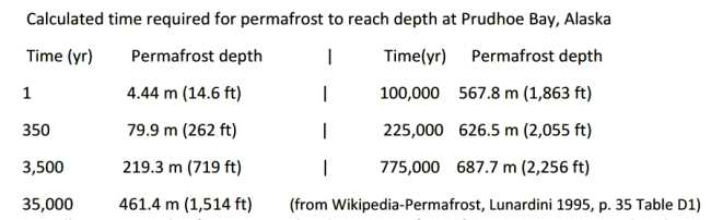
Needless to say the factors involved in permafrost formation to great depths are many and the calculations are very complex. However, considerable information on permafrost is available from oil wells in the Prudhoe Bay, Alaska, area.
While not actual reality of how the great depths of permafrost formed; the calculated ABSOLUTE MINIMUM possible time to form very thick permafrost, as that in Siberia, on the order of 1600 meters, using the properties of those of Prudhoe Bay, is 64,800 years !! (Lunardini 1995, p. 19 Table 5)
Conclusion a): The formation of deep layers of permafrost, those deeper than about 300 meters, is inconsistent with young Earth theories !!
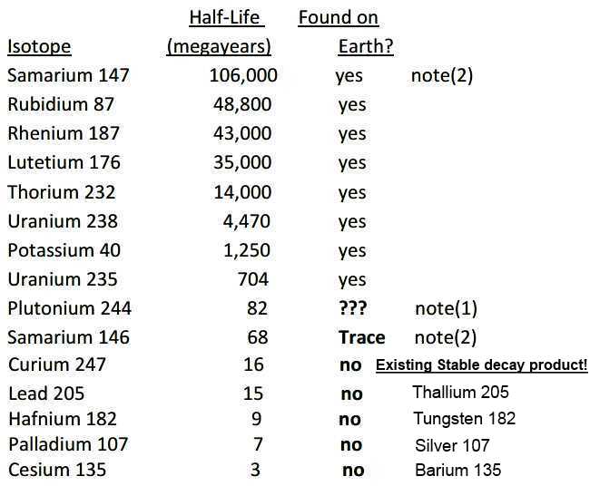
And we also get an indicator of the old age of the Earth from radioisotopes which are found on the Earth, and
those which are missing ! A total list of 36 missing down to 1,000 year half-lives.
................................................( 31 more no's not shown !)
note(1) Plutonium-244 was reported to have been found in 1971, but a later study in 2015 was unable to confirm this finding. However, "Live interstellar plutonium-244 has been detected in meteorite dust in marine sediments, although the levels detected are much lower than would be expected from current modelling of the in-fall from the interstellar medium." (Wikipedia-Plutonium-244)
note(2) Samarium-147 with a long half life of 106,000 million years is found, but Samarium-146 with a much shorter half life of 68 million years is found only in trace amounts per Wikipedia-Isotopes of samarium.
The above list is essentially compatible with the age many scientists propose for the Earth which is 4.55 billion years. Uranium 235's half life is 704 million years, so 4.55 billion years is just a bit over six half-lives. It's reasonable for Uranium 235 to still be around in small quantities after that amount of time. And, in fact, it makes up a little less than one percent of the Uranium now on the Earth. The amounts of Uranium 235 and Uranium 238 would have been about equal, 4.55 billion years ago.
Plutonium-244 has a half life of 82 million years, so 4.55 billion years is 55 half lives so its detection would be very difficult if even possible, but it has been detected in meteorite dust in marine sediments, so it exists in our solar system.
Samarium-147 has a half life of 106,000 million years and should thus be found. Samarium-146 has a half life of 68 million years, which means that Samarium-146 would be rarer than Plutonium-244.
Conclusion b): the isotopes found on the Earth and those missing are again NOT consistent with young Earth theories and reinforce the conclusion concerning the old age of the Earth !!
Also some 190 confirmed impact sites by the collision of meteors (consisting of large fragments of asteroids) or comets (consisting of ice, dust particles and rocky fragments) with the Earth must be accounted for. (see Wikipedia-List of impact craters on Earth) Some young earth theorists have proposed that virtually all of the impacts occurred during the "creation week." However, this entails major problems, including:
1. God's declarations in Genesis that the creation was "very good" at the end of time 6 including the time of the creation of Adam and Eve hardly seems consistent with the idea that a massive bombardment was taking place during any of this time. And that it was totally 100% "finished," in Gen 2:1. Unless all large bombardment was stopped just before their creations and/or the garden was protected ! And especially since some young earth theorists have the interpretation that the creation was "perfect" prior to the sin of Adam and Eve in the garden, but NO where does the Bible directly so state.
2. The Moon has many craters on it and since there is no reason to believe that the Earth has escaped the same
bombardment that hit the Moon, we can get an estimate of those on the Earth as shown below. The Earth has
about 13.5 times the surface area so we use that factor. We also get the last line which is a rough estimate of the
number of hits per year for only 6,000 years if the impact rate was relatively constant, but many seem to agree
that during the early stages of creation the rate was much higher.

Obviously way to many for a "very good" and "finished" Earth !! (Note: the Earth's atmosphere is such that the effect of the same size object will be different on the Earth than on the Moon and 70% may impact the seas. AMS recorded 5,449 bolides in 2017. Non-crater events have been reported in 1908/Tunguska, 1930/Curuca, 1963/Prince Edwards Islands, and 2013/ Chelyabinsk.)
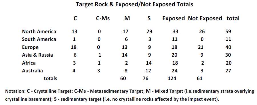
3. Large craters occur in the sedimentary geologic strata. Most young Earth creationists interpret these NOT as creation-week rocks, but as Flood or post-Flood deposits. Nearly three quarters of the 190 impacts sites known today were into sedimentary or a mixture of sedimentary strata overlying crystalline basement, or in the last 4367 YEC years. And two thirds of those are exposed to the surface and thus in upper sedimentary layers.
In recorded history by man, and including the Bible, large massive impacts have not been observed which eliminates much of recent time !!
However, minor impacts may have occurred such as listed above in the recent century, and including, by some unconfirmed proposals, events such as the destruction of Sodom and Gomorrah and the flood. Consider that possibly a 40 day multi-fragment ice comet shower cleaved (H1234) the wells (H4599) of the great (H7227) deep (H8415) causing tidal waves and that the deluge (H3999) of watern (H4325) was the result of rain from the ice portion of the comet (a dirty snowball) that evaporated upon entry into the atmosphere ! [see //news.bbc.co.uk/2/hi/ science/nature/2153650.stm "Comet 57P/du Toit-Neujmin-Delporte splinters" ]
Gen 1:28 And God blessed them. And God said to them, "Be fruitful and multiply and fill the earth and subdue it and have dominion over the fish of the sea and over the birds of the heavens and over every living thing that moves on the earth."
Gen 8:15-17 Then God said to Noah, "Go out from the ark, you and your wife, and your sons and your sons' wives with you. Bring out with you every living thing that is with you of all flesh--birds and animals and every creeping thing that creeps on the earth--that they may swarm on the earth, and be fruitful and multiply on the earth."
Gen 8:22 While the earth remains, seedtime and harvest, cold and heat, summer and winter, day and night, shall not cease." (ESV)
Then is it impossible that any massive impacts could interfere with man and animals being fruitful and multiplying before and after the flood unless it was the will of the LORD!!
The largest known impacts are considered as being "species-busters" that "they are portrayed as causing worldwide crop failures from dust injected into the atmosphere that could imperil civilization, and the largest-sized objects could make some species become extinct and possibly even humans!" Or with smaller "continent-busters" the human and animal death toll could be in the tens to hundreds of millions and could cause some global consequences, including global cooling caused by vast amounts of dust in the atmosphere!" (stason.org/ TULARC/ science-engineering/ astronomy)
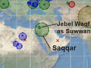
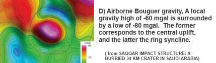
A large impact crater 34 kilometers in diameter in north western Saudi Arabia which is entirely in sedimentary material, called Saqqar, being in the top 40 in size world wide, would have caused extensive destruction to the southern area of the fertile crescent, the land of the Bible !! A 34 kilometer impact crater would have an ejecta blanket up to 110 km in diameter, and a zone of destruction extending much farther out.
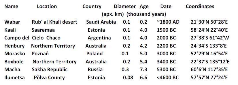
The data shows no major catastrophic impacts in recent history as Wikipedia lists only nine craters estimated to be less than ten thousand years old, and with a diameter of 100 m (330 ft) or more, and proposes that the largest in the last 100,000 years (100 ka) is the 4.5 km (2.8 mi) Rio Cuarto crater in Argentina. The Kaali impacts in Estonia (c. 2000 BC) during the Nordic Bronze Age may have influenced Estonian and Finnish mythology, the Campo del Cielo in Argentina (c. 2000 BC) could be in the legends of some Native American tribes, while Henbury in Australia (c. 2200 BC) may have figured in Australian Aboriginal oral traditions. (see Wikipedia pages for each crater site)
The Earth is still frequently visited by objects from space, the vast majority very small and most burn up in the atmosphere, and with no large impacts in recent millenniums before and after the flood as we would expect from the Bible record !!
Conclusion c): The information on known impact craters just does not fit into a young Earth concept, only into an old Earth concept!!
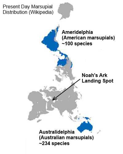
It would appear that there were NO marsupials on the Ark !!
Answer: "Thus the heavens and the earth were finished, and all the host of them." Gen 2:1
God had finished the creation and placed the marsupial species where shown above !!
(Finished means Finished, 100% Finished and a "very good" habitat for mankind!!)
The deluge of Noah's time impacted only where fallen mankind lived at the time.
"And it came to pass, when men began to multiply on the face of the earth,...Gen 6:1
Gen 11:8 So the LORD scattered them abroad from thence upon the face of all the earth (land): and they
left off to build the city.
Gen 11:9 Therefore is the name of it called Babel; because the LORD did there confound the language of
all the earth (people): and from thence did the LORD scatter them abroad upon the face of all the
earth (land)
The scattering abroad over all the planet did not occur until chapter 11 !!
The translation conundrum is that H776 (erets) is most often translated as "land".
Gen_2:12 And the gold of that landH776 is good: there is bdellium and the onyx stone.
Gen_2:13 And the name of the second river is Gihon: the same is it that compasseth the whole landH776 of Ethiopia.H3568
But when the translators come to the flood narrative they most often translate H776 (erets) as
"earth" and from this many have assumed it means the entire planet earth !
Gen_6:12 And God looked upon the earth (land),H776 and, behold, it was corrupt;
forH3588 all flesh had corrupted his way upon the earth (land).H776
Gen_6:13 And God said unto Noah, The end of all flesh is come before me;
for the earth (land)H776 is filled with violence through them; and, behold, I will
destroy them with the earth (land).H776
Gen_6:17 And, behold, I, even I, do bring a flood of waters upon the earth
(land),H776 to destroy allH3605 flesh, wherein is the breath of life, from under
heaven (sky); and every thing that is in the earth( land)H776 shall die.
The translation of H776 (erets) as "land", as a part of the planet, is the preferred translation except in a limited number of occurrences when by the context it obviously refers to the entire planet !!
Gen 7:1 And the LORD said unto Noah, Come thou and all thy house into the
ark; for thee have I seen righteous before me in this generation.
Gen 7:2 Of every clean beast thou shalt take to thee by sevens, the male and
his female: and of beasts that are not clean by two, the male and his
female.
Gen 7:3 Of fowls also of the air by sevens, the male and the female; to keep
seed alive upon the face of all the land.H776
Gen 7:4 For yet seven days, and I will cause it to rainH4305 upon the b>landH776 forty
days and forty nights; and every living substance that I have made will I
destroy from off the face of the land.
Gen 7:5 And Noah did according unto all that the LORD commanded him.
Gen 7:6 And Noah was six hundred years old when the floodH3999 of watersH4325 was
uponH5921 the land.H776
Gen 7:7 And Noah went in, and his sons, and his wife, and his sons' wives with him,
into the ark, because of the watersH4325 of the flood.H3999
Gen 7:8 Of clean beasts, and of beasts that are not clean, and of fowls,
and of every thing that creepeth upon the land,H127
Gen 7:9 There went in two and two unto Noah into the ark, the male and the
female, as God had commanded Noah.
Gen 7:10 And it came to pass after seven days, that the watersH4325 of the floodH3999 were
upon the land.H776
Gen 7:11 In the six hundredth year of Noah's life, in the second month, the
seventeenth day of the month, the same day were all the wellsH4599 of the
great deep cleaved,H1234 and the windows of heaven were opened.
Gen 7:12 And the rain was upon the landH776 forty days and forty nights.
Gen 7:13 In the selfsame day entered Noah, and Shem, and Ham, and
Japheth, the sons of Noah, and Noah's wife, and the three wives of his sons
with them, into the ark;
Gen 7:14 They, and every beast after his kind, and all the cattle after their kind,
and every creeping thing that creepeth upon the landH776 after his kind, and every
fowl after his kind, every bird of every sort.
Gen 7:15 And they went in unto Noah into the ark, two and two of all
flesh, wherein is the breath of life.
Gen 7:16 And they that went in, went in male and female of all flesh, as God
had commanded him: and the LORD shut him in.
Gen 7:17 And the floodH3999 was forty days upon the land;H776 and the watersH4325
increased, and bare up) the ark, and it was lift up above the land.H776
Gen 7:18 And the watersH4325 prevailed, and were increased greatly upon the land;H776 and the
ark went upon the face of the waters.H4325
Gen 7:19 And the watersH4325 prevailed exceedingly upon the land;H776 and all the
high hills,H2022 that were under the whole heaven, were covered.
Gen 7:20 Fifteen cubits upward did the watersH4325 prevail; and the high hillsH2022
were covered.
Gen 7:21 And all flesh died that moved upon the land,H776 both of fowl, and of
cattle, and of beast, and of every creeping thing that creepeth upon the land,H776
and every man:
Gen 7:22 All in whose nostrils was the breath of life, of all that was in the
dry land, died.
Gen 7:23 And every living substance was destroyed which was upon the face of
the ground,H127 both man, and cattle, and the creeping things, and the fowl
of the heaven; and they were destroyed from the land:H776 and Noah only
remained alive, and they that were with him in the ark.
Gen 7:24 And the watersH4325 prevailedH1396 uponH5921 the landH776 an hundredH3967 and fiftyH2572 days.H3117
The same translation problem is readily corrected by many translations and commentaries in Gen 41:56-57, not all the planet earth, but all the countries/lands around Egypt
Gen 41:56 And the famine was over all (kol) the face of the earth (H776 erets): And Joseph opened all the storehouses, and sold unto the Egyptians; and the famine waxed sore in the land of Egypt. (KJV)
(ESV) So when the famine had spread over all the land, Joseph opened all the storehouses and sold to the Egyptians, for the famine was severe in the land of Egypt.
(YLT) And the famine has been over all the face of the land, and Joseph openeth all places which have corn in them, and selleth to the Egyptians; and the famine is severe in the land of Egypt,
(LITV) And the famine was on the face of all the land. And Joseph opened all which was in them, and sold to the Egyptians. And the famine was strong in the land of Egypt.
Gen 41:57 And allH3605 countriesH776 cameH935 into EgyptH4714 toH413 JosephH3130 for to buyH7666 corn;
becauseH3588 that the famineH7458 was so sore "Genesis 41:57
Genesis 41:57 The Easy to Read Version (ERV) paraphrases it this way;
And all countries came into Egypt to Joseph for to buy corn,.... All the neighbouring nations (Syria,
Arabia, Palestine, Canaan, &c.), when they heard there was corn there for money, came from all parts for it,
and were glad to get it at such expense and trouble: " (John Gill's Exposition of the entire Bible)
"The famine was sore in all lands — that is, the lands contiguous to Egypt - Canaan, Syria, and
Arabia. "(Jamieson, Fausset, and Brown Commentary)
"but the famine was bad everywhere. So people from the countries around Egypt had to come to Joseph in
Egypt to buy grain."
Return